
Blacklaw Tower


Building(S) (16th Century), Enclosure(S) (Medieval), Kiln (Post Medieval), Kiln Barn (Post Medieval), Tower House (16th Century)
Site Name Blacklaw Tower
Classification Building(S) (16th Century), Enclosure(S) (Medieval), Kiln (Post Medieval), Kiln Barn (Post Medieval), Tower House (16th Century)
Alternative Name(s) Blacklaw Burn; Blacklau; Blacklaw Tower-house
Canmore ID 48348
Site Number NT00NE 3
NGR NT 05224 06735
Datum OSGB36 - NGR
Permalink http://canmore.org.uk/site/48348


- Council Dumfries And Galloway
- Parish Moffat
- Former Region Dumfries And Galloway
- Former District Annandale And Eskdale
- Former County Dumfries-shire
NT 05210673 NT00NE 3
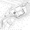
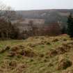
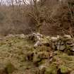
Blacklaw tower-house, its outbuildings and enclosures, are situated in a forestry clearing towards the head of the slope on the right bank of the Blacklaw Burn. It is advantageously situated, with the principal enclosure accounting for an area of relatively level ground, divided by a terrace, bounded on the SSE and ENE by a meander of the burn, while the tower itself is placed at the point where the burn descends precipitously into a steep gully.
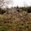
The tower, which is probably of 16th-century date, has been reduced to its vaulted ground floor and a fragment of the first floor, which today are almost entirely concealed by a turf-covered mound. It is rectangular on plan (9.7m by 7.5m over walls at ground level up to 1.7m thick) and constructed of random rubble externally built to a course, the SE long-wall standing to a height of 2.5m. The entrance-doorway, which has been robbed of its dressings and obscured by a build-up of earth and rubble, was towards the NE end of the SE wall. It opened to the basement and, immediately on entering, to a newel stair contrived in the E angle of the tower giving access to the first-floor hall. The basement was lit by a slit-window in each end-wall; the vault, already partially collapsed, is in a parlous condition. At first-floor level, the only visible feature, cleared of its debris in 1991 by A M T Maxwell-Irving, is a mural window recess central to the SE wall. The recess is internally splayed with stone seats and (0.6m above and 0.15m wide at the daylight) a high-level slit window, the lintel of which is in situ and wrought with a 40mm chamfered arris. Traces of limewash adhere to the internal masonry.
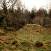
To the ENE of the tower, the ground is enclosed by a substantial stone-walled enclosure which is conceivably the remains of an earlier bawn or pele. The enclosure is roughly square on plan (46m by 43m overall) but has been tailored on the WSW by the return of a cross-wall, separated from the tower by a hollowed trackway. The enclosure wall, double-skinned with a rubble core, is massively constructed, on the SSE having the appearance of two phases of construction, 2.1m thick overall and up to 1.3m high. A natural terrace (up to 2.7m high) divides the interior of the enclosure into two levels. The terrace itself is devoid of detail and may have been cultivated, while the more sheltered ground at its foot appears to have been exclusively set apart for buildings, possibly ancillary service ranges and domestic accommodation.
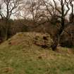
In a low-lying position, directly to the SSE and at right angles to the tower-house, with which it is probably contemporary, there are the remains of a building, probably a kitchen range. It measures 11m from NNW to SSE by 6.7m transversely over turf-covered stone walls up to 1.3m in thickness and 0.7m in height. The entrance was towards the SSW end of the ENE wall. The SSE end-wall (3.3m thick) incorporates a substantial fireplace which is offset from centre, the intervening space probably being filled by a bread-oven. The fireplace measures 2.4m across the reveal and has jambs 2.3m deep. On the SSE side of the building there are traces of an outshot (5.7m by 5.9m transversely over stone-wall footings 0.7m thick and 0.3m high). The WSW wall of the range serves in lieu of the bawn-wall on this side, and on the exterior, where it is grounded on bedrock, it stands to a height of 1.8m.
The SSE side of the enclosure is occupied by a range of at least three compartments, measuring 12.3m from WSW to ENE by 4m transversely over turf-covered boulder footings about 0.9m in thickness and 0.3m in height. This range may once have extended the full length of the wall but its remains are so severely wasted it is not possible to say.
Alongside the ENE wall of the enclosure, either side of a postern-gateway (1.4m wide), there are the remains of two buildings. The larger, and by virtue of its size probably a hall, is set parallel to the enclosure-wall (2m apart) and measures 12m from NNW to SSE by 6.6m transversely over stone and boulder walls up to 1m in thickness and 0.8m in height where best preserved. A 1.3m wide break in its WSW long-wall probably indicates the site of the entrance. The neighbouring building, to the SSE, measures 6m from SW to NE by 4.4m transversely over turf-covered stone wall-footings up to 0.8m in thickness and 0.7m in height.
To the NE of the enclosure, athwart the intervening ground between the enclosure and the burn, there are the turf-covered remains of a substantial rectangular building (14.7m from WSW to ENE by 4.7m transversely over stone wall-footings up to 1.7m thick and 0.6m high) with rounded outer angles and an entrance central to its NNW long-wall. A hollowed trackway passes beside the WSW end-wall and drops downslope to the postern-gateway. A notable feature of this site is the placing of substantial boulders to protect vulnerable building angles. Several of these are evident close to the WSW end-wall of the above building and they are also employed to either side of the postern-gateway, and at the head of the track leading away from the tower. Another trackway, which extends parallel with the NNW side of the enclosure, and bifurcates to join with that first mentioned above, was bridged across the burn and the surviving abutment on the left bank is particularly well preserved.
On the NNW side of the tower-house there is a subsidiary enclosure (up to 21m by 18m) defined by a turf-and-stone bank up to 1m thick and 0.3m high. This bears close comparison with the form of barmkin attached to other towers in the district (eg Mellingshaw). On the NW side of the enclosure, projecting to the exterior, its SSE wall coterminous with the bank (although the stratigraphic relationship is unclear), there is a building which has been terraced into the slope. It measures 13m from WSW to ENE by 5.2m transversely over turf-covered stone wall-footings 0.7-0.9m in thickness and up to 0.5m in height. The entrance (1.5m wide) was probably central to the NNW long-wall. The S external angle of the building is protected by a large boulder.
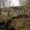
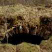
At the head of the burn gully, to the WSW of the above enclosure and end-on to the leading edge of the slope, there are the remains of a two-compartment building, probably a kiln-barn and the only surviving example of its type to be noted in this district. It measures 10.5m from NNW to SSE by up to 5.2m transversely over turf-covered stone walls up to 0.9m in thickness and 0.4m in height. The entrance was probably in the NNW end-wall. The SSE compartment, which is trapezoidal on plan (5.2m by 3.8m) probably housed the kiln-bowl. Although there is no trace of a flue, this probably emitted from the SSE end-wall which is externally revetted.
Some 20m to the WSW of the probable kiln-barn, there are the turf-covered remains of a bowl-kiln. The bowl, which has been let into the leading edge of the slope at the head of the burn gully, has a diameter of up to 3.3m and a depth in excess of 1.8m; the flue was on the SE. The masonry lining the bowl appears to be well preserved.
In a forestry ride, some 40m to the N of the tower-house, beside a 19th-century field-wall, there are the wasted remains of an enclosure. It measures 9.5m from WNW to ESE by 7.4m transversely over a rubble wall spread up to 1.3m in thickness.
Set apart from the tower-house and its outbuildings, some 20m to the SSW on the opposite side of the burn, there is a building which, in point of size, is particularly noteworthy. It sits astride and has been terraced into the slope, and possibly overlies a hollowed trackway. The building, probably of at least three compartments, measures 22.3m from NW to SE by 5.2m transversely over turf-covered walls about 1.6m in thickness and 0.6m in height. A substantial block of rock outcrop is incorporated in the NE long-wall. At the NW end of the building there is an outshot (5.2m by 4.2m) with a massively pinned end-wall. On the SW side of the building there is a sizeable enclosed area which has probably been cultivated. The SW side of this enclosure is defined by a bank which emerges from the bracken as a stone wall up to 1.7m thick and 0.4m high that extends to the edge of the burn.
The lands of Blaclau are on record about 1315 when they were granted by King Robert I to Sir David de Lyndsay, younger of Crawford (RMS iii, 868). Subsequently they passed to the Herries of Terregles, in 1510, having been apprized by the Crown, they were re-granted to the Maxwells, passing later that century (and before 1592) to the Johnstons. In 1647, James Johnston of Corehead, sold the lands to Lieutenant-Colonel William Johnston, younger son of the 1st Earl of Hartfell.
Visited by RCAHMS (IMS), May 1992.
Reg Mag Sig; W Fraser 1894; J B Paul 1907; Hope-Johnstone MSS. (retained by the Annandale family).
Listed as tower.
RCAHMS 1997.
NT00NE 3 0521 0673
(NT 0521 0673) Blacklaw Tower (NR) (Remains of)
OS 6" map, (1957).
Blacklaw Tower, apparently erected in the 16th century, is in a bad state of repair. Only the vaulted lower storey, 32' N-S by 25', with 5' thick walls, remains. The vault at the S end has already fallen in and other portions are likely to do so. The tower is enclosed by out-buildings and yards, some of which are probably secondary. A courtyard extends to the NE with an entrance in its N wall, and N of this are the abutments of a little bridge over the burn.
RCAHMS 1920, visited 1911
Generally as described. The courtyard measures 33.0m NE-SW by 40.0m.
Revised at 1/2500.
Visited by OS (I A) 1 October 1973
No change to previous field report.
Surveyed at 1:10,000
Visited by OS (T R G) 16 September 1978
Measured Survey (14 March 1991 - 15 March 1991)
RCAHMS surveyed Blacklaw Tower and farmstead between 14-15 March 1991 with plane-table and self-reducing alidade at a scale of 1:500. A ground- and first-floor plans of the tower house at a scale of 1:100 were also produced. The site plan was redrawn in ink and published at a scale of 1:1000 (RCAHMS 1997, Fig. 227).

