Measured Survey


Date 14 March 1991 - 15 March 1991
Event ID 1150037
Category Recording
Type Measured Survey
Permalink http://canmore.org.uk/event/1150037
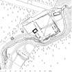
RCAHMS surveyed Blacklaw Tower and farmstead between 14-15 March 1991 with plane-table and self-reducing alidade at a scale of 1:500. A ground- and first-floor plans of the tower house at a scale of 1:100 were also produced. The site plan was redrawn in ink and published at a scale of 1:1000 (RCAHMS 1997, Fig. 227).