|
Prints and Drawings |
FID 22/1 |
Records of the Royal Commission on the Ancient and Historical Monuments of Scotland (RCAHMS), Edinbu |
Plan, ink, 1":30' RCAHMS |
1925 |
Item Level |
|
|
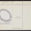
Prints and Drawings |
FID 22/2 |
Records of the Royal Commission on the Ancient and Historical Monuments of Scotland (RCAHMS), Edinbu |
PTS, pencil, 1":30' RCAHMS |
1925 |
Item Level |
|
|
Manuscripts |
MS 7649 |
Rebecca Shaw Archaeological Services |
Report: 'Kier Plantation, Kincardine. Castlehill Wood, Kincardine. Callandar Wood, Falkirk. Archaeological Topographic Survey of three forts in the Scottish Lowlands' |
17/6/2011 |
Item Level |
|
|
Digital Files (Non-image) |
GV 007301 |
Rebecca Shaw Archaeological Services |
Vector graphic topographic survey, Castlhill Wood, Kincardine |
c. 6/2011 |
Item Level |
|
 |
Digital Files (Non-image) |
WP 005972 |
Rebecca Shaw Archaeological Services |
Topographic Survey Report: 'Callendar Wood, Keir Plantation & Castle Hill', June 2011 |
13/6/2011 |
Item Level |
|
 |
Digital Files (Non-image) |
WP 005973 |
Rebecca Shaw Archaeological Services |
Report: 'Kier Plantation, Kincardine Castlehill Wood, Kincardine Callandar Wood, Falkirk, Archaeological Topographic Survey of three Forts in the Scottish Lowlands', June 2011 |
17/6/2011 |
Item Level |
|
 |
On-line Digital Images |
SC 2434751 |
Records of the Ordnance Survey, Southampton, Hampshire, England |
Castlehill Wood, NS98NE 1, Ordnance Survey index card, page number 1, Recto |
c. 1958 |
Item Level |
|
 |
On-line Digital Images |
SC 2434752 |
Records of the Ordnance Survey, Southampton, Hampshire, England |
Castlehill Wood, NS98NE 1, Ordnance Survey index card, page number 2, Verso |
c. 1958 |
Item Level |
|
 |
On-line Digital Images |
SC 2434753 |
Records of the Ordnance Survey, Southampton, Hampshire, England |
Castlehill Wood, NS98NE 1, Ordnance Survey index card, Recto |
c. 1958 |
Item Level |
|
 |
On-line Digital Images |
SC 2434754 |
Records of the Ordnance Survey, Southampton, Hampshire, England |
Castlehill Wood, NS98NE 1, Ordnance Survey index card, Recto |
c. 1958 |
Item Level |
|
|
All Other |
551 605/1/1 |
Rebecca Shaw Archaeological Services |
Reports from archaeological Topographic Survey of three Forts, Kier Plantation, Kincardine, Castlhill Wood, Kincardine and Callandar Wood, Falkirk |
13/6/2011 |
Batch Level |
|
|
All Other |
551 605/1/2 |
Rebecca Shaw Archaeological Services |
Vector graphics from archaeological Topographic Survey of three Forts, Kier Plantation, Kincardine, Castlhill Wood, Kincardine and Callandar Wood, Falkirk |
c. 6/2011 |
Batch Level |
|
|
All Other |
551 166/1/1 |
Records of the Ordnance Survey, Southampton, Hampshire, England |
Archaeological site card index ('495' cards) |
1947 |
Sub-Group Level |
|
|
All Other |
551 605/1 |
Rebecca Shaw Archaeological Services |
Archaeological Topographic Survey of three Forts, Kier Plantation, Kincardine, Castlehill Wood, Kincardine and Callendar Wood, Falkirk |
9/4/2011 |
Sub-Group Level |
|


