
Castlehill Wood


Earthwork (Period Unassigned)
Site Name Castlehill Wood
Classification Earthwork (Period Unassigned)
Alternative Name(s) Castle Hill Enclosure, Bogside Wood
Canmore ID 48018
Site Number NS98NE 1
NGR NS 9711 8992
Datum OSGB36 - NGR
Permalink http://canmore.org.uk/site/48018


- Council Fife
- Parish Culross
- Former Region Fife
- Former District Dunfermline
- Former County Fife
NS98NE 1 9711 8992.
(NS 9711 8992) Fort (NR)
OS 6" map, (1948)
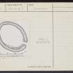
Fort: In Castlehill Wood is a small plateau of very regular oval form with its major axis NW-SE. Surrounded by a single ditch it measures 185' x 135'. At the SE the ditch has been left uncut in order to provide a passage for the entrance. This has been about 20' wide and at its inner end there are on either side faint traces of a low mound, which in all probability once ran right round the edge of the enclosure, and which may have been palisaded.
RCAHMS 1933.
This oval earthwork is situated in a thick wood on low-lying ground. A ditch can be traced round most of its perimeter, but is scarcely discernible on the W; vegetation rendered close examination of this difficult. As stated above, a causewayed entrance can be seen on the SE. It does not have the appearance of being a defensive work.
Visited by OS (J L D) 3 July 1953.
Generally as described, although the earthwork has been further mutilated by forestry operations and cannot be classified with any certainty.
Visited by OS (D W R) 20 May 1974.
An unclassifiable earthwork
Visited by RCAHMS (J B S) 22 October 1984.
Field Visit (23 April 1925)
Fort, Castle Hill, Castlehill Wood.
In Castlehill Wood, about 250 yards to the southwest of Bogside Railway Station, and at an elevation of 200 feet above sea-level, is a small plateau of very regular oval form with its major axis north-west and south-east. It is surrounded by a single ditch, the well-marked enclosure thus produced having a maximum measurement of 185 by 135 feet. At the southeast the ditch has been left uncut in order to provide a passage for entrance. This passage has been about 20 feet wide, and at its inner end there are on either side faint traces of a low mound, which in all probability once ran right round the edge of the enclosure and which may have been palisaded.
RCAHMS 1933, visited 23 April 1925.
Ground Survey (9 April 2011 - 10 June 2011)
NS 946 882, NS 971 899 and NS 896 787 A programme of surveys was undertaken 9 April–10 June 2011 on three forts in the Scottish lowlands.
Kier Plantation fort is located roughly half way up the eastern side of Moor Loch in an area of mixed woodland. The W of the site is bordered by the Moor Loch, the N by marshy ground that was originally part of the loch and the E and S by flat ground. The fort is sub-circular in shape and a maximum of c70m in diameter, with a number of banks and ditches. There is a knoll at the N end that would have originally formed a promontory into the loch. Although there is no internal rampart the incline on the inner face of the ditch is very sharp, reaching 1.5m high in places. A definite break in the bank and ditch mark the position of a possible entrance to SW.
Castlehill Wood fort is located on fairly level low-lying ground in mature trees within Bogside Wood. The fort is oval in shape and measures c70m NW–SE by 48m NE–SW and is mostly surrounded by a bank and ditch, although the ditch is barely visible in the W. There is an entrance in the SE.
Callendar Wood fort is located in an area of mixed deciduous trees in Callendar Wood. The fort is sub-rectangular in shape, measures c155m E–W by 93m N–S and consists of a ditch with an external bank. The ditch measures between c0.3–3.0m in depth and is deepest at the E end. The ditch is least visible along a small southern section. There is an entrance in the SE flanked on either side with fairly large banks, and a possible smaller entrance in the SW. Two much smaller ditches, which are aligned roughly N–S across the site, appear to be later additions and are possibly associated with later drainage related to the footpath.
Archive: RCAHMS. Report: Fife and North Lanarkshire SMR
Funder: Forestry Commission Scotland
Rebecca Shaw Archaeological Services, 2011

