
Nether Abington


Motte And Bailey (12th Century)
Site Name Nether Abington
Classification Motte And Bailey (12th Century)
Alternative Name(s) Abington Motte
Canmore ID 47438
Site Number NS92SW 3
NGR NS 9323 2498
Datum OSGB36 - NGR
Permalink http://canmore.org.uk/site/47438


- Council South Lanarkshire
- Parish Crawfordjohn
- Former Region Strathclyde
- Former District Clydesdale
- Former County Lanarkshire
NS92SW 3 9323 2498.
(NS 9323 2498) Motte & Bailey (NR)
OS 6" map (1957)
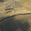
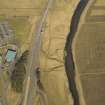
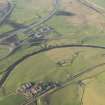
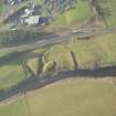
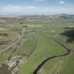
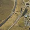
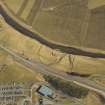
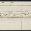
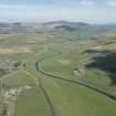
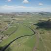
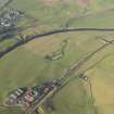
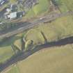
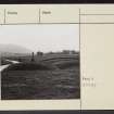
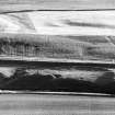
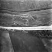
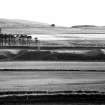
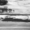
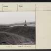
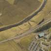
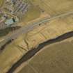
This motte and bailey lies immediately W of the River Clyde. The bailey stands some 30ft above the river, while the motte is 6ft higher. The latter is defended on the E by the river, on the S by a small ravine, on the W by a marsh. Its flat top measures 70ft N-S by 35ft transversely, and it is situated at the SE end of the bailey, from which it is separated by a ditch some 5ft deep. The somewhat horseshoe shaped bailey measures about 240 by 180ft; it is enclosed by an earthen rampart, 5ft maximum height, starting at the edge of the river bank on the N, and curving round to join the S end of the motte-ditch at the ravine.
On excavating the motte, Irving found that it was covered with several inches of wood charcoal mixed with animal remains.
(Information from RCAHMS)
G V Irving and A Murray 1864; D Christison 1890
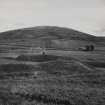
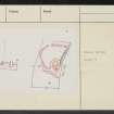
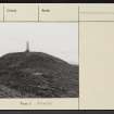
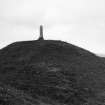
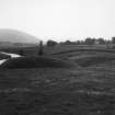
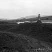
A motte and bailey, generally as described. The motte, 5.5m high on the S side with a level disturbed top 21.0m N-S by 12.0m E-W, has a modern stone memorial on its top; it is protected on the S side by a natural wide gulley.
The bailey area is undulating though featureless, with maximum internal dimensions of 65.0m N-S by 60.0m E-W. Its rampart is cut n the N side by a 6.0m wide track. This may be on the line of an original entrance, although a 4.0m wide rounded gap on the SW side appears original. The silted remains of a 10.0m wide external ditch, 0.5m deep, exist around the N arc.
Surveyed at 1:2500.
Visited by OS (JRL) 3 August 1978
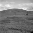
This is the best preserved motte-and-bailey to be found in the area. The construction rises abruptly from the left bank of the Clyde. It consists of a sub-circular motte, on the south measuring 20m by 12m and standing up to 2m in height above the surrounding pasture land. To the north and west lies the bailey somewhat oval in shape and measuring 88m from north- east to south-west by 60m transversely. Both motte and bailey are surrounded on all sides by a ditch, except on the east where the structures are protected naturally by the waters of the Clyde. Excavation in the nineteenth century uncovered evidence for occupation upon the summit of the motte.
C Tabraham 1978
Photographed by the RCAHMS in 1980.
Field Visit (2 September 1942)
Mote, Abington.
The remains consist of a mote and bailey in fairly good preservation. They stand on the W bank of the Clyde about [1km] N of Abington, at a point where the ground slopes gently down from the W to form a low cliff edge of the river. The bailey (cf. Christison [1890]) is a bag-shaped rather than a D-shaped enclosure, with the ends of its rampart resting on the riverbank; the rampart appears to be constructed of gravelly clat obtained from the ditch that lies outside it. This ditch is broad, shallow and marshy except on the S, where it has been deepened by a streamlet towards its debouchmont into the river. There are two principal gaps in the rampart, on NW and SW, but it is uncertain whether either of them is original; the one on the NW, at any rate, has been enlarged in recent times. The mote-hill stands in the S corner of the bailey, its E side descending directly to the river and its other sides being separated from the bailey by a ditch. Neither this ditch nor that of the bailey appears to be rock-cut, and they are probably sunk only to the bottom of the boulder-clay overlying the rock.
Visited by RCAHMS (AG) 2 September 1942.
Publication Account (1985)
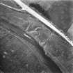
The motte at Abington is the only earthwork castle in upper Clydesdale to retain its outer bailey. The site has been carefully chosen to make maximum use of natural defences with, on the south-east, a steep drop of some 10m down to the Clyde and a lesser stream protecting the south-west flank. The motte is tucked into the angle between the two water courses and is defended on the north and east by a ditch lam broad and 1.5m deep. The oval mound rises to a height of 2m above the interior of the bailey and its summit measures 20m by 12m. There is no causeway across the ditch, and the timber tower that once crowned the mound must have been reached by a wooden bridge. The bailey lies to the north; it is irregular on plan, measuring a maximum of 80m by 58m within an earthen rampart accompanied by an external ditch. A modem track breaches the rampart on the north, but the original entrance is probably represented by a 4m wide gap on the south-west
The estate associated with the motte probably corresponded with the bounds of the parish of Crawfordjohn, within which it lies, and John of Crawford appears as a witness on a charter oflands in Lesmahagow between the years 1147 and 1164.
Information from ‘Exploring Scotland’s Heritage: The Clyde Estuary and Central Region’, (1985).
Geophysical Survey (February 1990)
Detailed survey of several sites in the area prior to the M74 motorway.
Field Visit (6 February 2015)
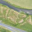
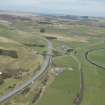
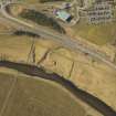
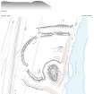
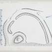
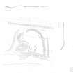
This motte and bailey castle is situated on the W bank of the River Clyde, wedged between the river and the public road to Edinburgh (A702), which has encroached upon its ditch to the W. The motte has been raised on a river terrace in which stone outcrops and, in consequence, has an unusual, sub-triangular shape on plan that narrows to a point on the S. It measures 28m from N to S by 20m transversely at its widest point and stands to 2m in height above the bailey. The top of the motte is 22m by 11m in extent. It is surrounded by a ditch 10m in breadth by up to 2m in depth, the contents of which have presumably been used to raise the motte. There is a slight dip in the WNW of the motte, which may mark the site of an entrance. However, a slight bank along its edges and other minor features on top of the motte may be a relic of the construction of a monument to a local fisherman that has been raised in the centre of the motte, or the excavations that took place in the 19th century (see below).
The bailey, which extends some 70m from N to S by 60m transversely, is enclosed by an earthen rampart 5m in breadth and up to 1.5m in height with a outer ditch about 10m in width that broadens and deepens from nothing on the W to more than 2m as it nears the river on the S due to erosion by the stream course that drains the marshy ground to the W. The original entrance is in the SW, marked by a gap in the rampart that has in-turned terminals; a second gap in the bank on the NNW has been made by a track. Where the rampart meets the ditch around the motte it has been turned in to limit access.
There is a possible turf building in the bailey that sits on the edge of the river terrace and measures 18m from E to W by 5m transversely overall, and there is a short length of a shallow ditch parallel to it on the S near the ditch of the motte. A small platform has been cut into the back of the rampart on the NW and there is a hollow in the S part of the bailey, sub-divided by a N-S terrace, possibly due to quarrying.
Excavations in the 19th century by Irving found a charcoal and animal bone spread, presumably a midden, 6 feet down in the middle of the motte, presumably on the old ground surface (Irving and Murray, I, 27-8). No direct documentation for the castle has been found, but John of Crauford, who was witness to a charter of lands in Lesmahago to Kelso Abbey between 1147 and 1164 (OPS I, 160-1) may be the lord of the estate in the mid-12th century that gave his name to the parish, and he or his descendants may have been responsible for the construction of the motte.
Visited by RCAHMS (PD, WW, AMcC) 6 February 2015
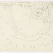
Measured Survey (5 March 2015 - 6 March 2015)
RCAHMS surveyed Abington motte with plane-table and self-reducing alidade between 5-6 March 2015 at a scale of 1:500. Control points and section were recorded with GNSS. The resultant plan and section were redrawn in vector graphics software.

