
Richie Ferry


Enclosure (Prehistoric)(Possible), Settlement (Prehistoric)(Possible)
Site Name Richie Ferry
Classification Enclosure (Prehistoric)(Possible), Settlement (Prehistoric)(Possible)
Alternative Name(s) Ritchie Ferry
Canmore ID 47429
Site Number NS92SW 21
NGR NS 94640 21601
Datum OSGB36 - NGR
Permalink http://canmore.org.uk/site/47429


- Council South Lanarkshire
- Parish Crawford
- Former Region Strathclyde
- Former District Clydesdale
- Former County Lanarkshire
Field Visit (11 July 1955)
NS 9462 2161. The summit of a small hill is surrounded by a slight, non-defensive, earthen bank.
Visited by OS (JD) 11 July 1955
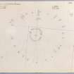
Measured Survey (20 August 1968)
RCAHMS surveyed this enclosure by plane-table on 20 August 1968 at a scale of 1mm:1ft. The resultant plan was redrawn in ink in 1974 and published in the County Inventory of Lanarkshire (RCAHMS 1978) as Fig. 42.
Field Visit (February 1975)
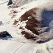
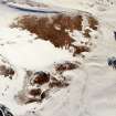
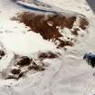
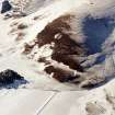
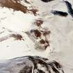
NS 946 216. A roughly circular enclosure occupies the summit of a knoll 75m E of settlement NS92SW 18. Measuring about 18m in diameter internally, it has been bounded by a single bank at least 3m in thickness, but now nowhere more than 0.4m high. The material for the bank was apparently obtained from shallow external quarry-ditches, whose positions are indicated by a more luxuriant growth of grass at various points on the S and SE arcs. There are two possible entrances, on the E and NW respectively, but the interior is featureless.
RCAHMS 1978, visited February 1975
Field Visit (26 March 1978)
NS92SW 21 9462 2161.
The enclosure, as described and planned by the RCAHMS, appears of similar construction and of the same state of preservation as the homestead (RCAHMS refers) some 200.0m to the west (see NS92SW 35), though there are no traces of dwellings within it.
Surveyed at 1:10000.
Visited by OS (NKB) 26 March 1978.
Publication Account (1985)
This inconspicuous ridge was a particularly favoured spot for settlement during the later first millennium BC/early first millennium AD (possibly on account of its sunny aspect and sheltered position), and along its crest there are the remains of no less than three separate settlement sites which show an interesting range of defences and house-types.
The most prominent [NS92SW 18] occupies high ground at the west end of the ridge. This is the largest and most heavily defended of the settlements, but even so, it cannot be classified as a fort, since the single rampal1 offers only a modest defence, and was built by scraping material from the interior, not by digging an external defensive ditch as would have been the case when building a fort. On the north-west traces of three clearly defined quarry scoops can be seen cut into the slope behind the rampart. Three of the four gateways lead straight into the interior, but on the south-west anyone entering the settlement would have been turned to the left before climbing up towards the crest of the ridge. In the interior there are the remains of at least eight buildings, all round timber houses but built using two different techniques. The five on the south-west were placed on platforms excavated into the slope and closely resemble the houses seen in unenclosed platform settlements; the second group, which lie in the north-west, are examples of the ring-ditch style, in which the principal posts were set in a continuous bedding-trench, and this trench can still be seen as a slight depression.
The homestead [NS92SW 33] lies to the west of the settlement and is tucked into the foot of the ridge. It comprises an oval enclosure surrounded by the remains of a ruined stone wall with an entrance on the south-south-west; on the west side of the interior there is a single house platform. To the south-east there are the remains of a small enclosure [NS92SW 23] which may be associated either with the homestead or the settlement. About 75m east of the settlement there is an embanked enclosure [NS92SW 21] (not illustrated), measuring about 18m in internal diameter, which may have surrounded a timber house.
The ridge thus contains traces of at least three phases of settlement; without excavation it is not possible to be certain of the chronological relationships between them, but it is likely that the settlement preceded the homestead.
Information from ‘Exploring Scotland’s Heritage: The Clyde Estuary and Central Region’, (1985).
Geophysical Survey (February 1990)
Detailed survey of several sites in the area prior to the M74 motorway.

