
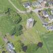
Cambuskenneth Abbey


Abbey (Medieval), Bell Tower (13th Century)
Site Name Cambuskenneth Abbey
Classification Abbey (Medieval), Bell Tower (13th Century)
Alternative Name(s) Abbey Of St Mary Of Stirling
Canmore ID 47271
Site Number NS89SW 4
NGR NS 80852 93961
NGR Description Centred on NS 80852 93961
Datum OSGB36 - NGR
Permalink http://canmore.org.uk/site/47271


First 100 images shown. See the Collections panel (below) for a link to all digital images.
- Council Stirling
- Parish Stirling
- Former Region Central
- Former District Stirling
- Former County Stirlingshire
NS89SW 4 80852 93961
For logboat found in the (adjacent) River Forth and displayed in the abbey tower, see NS89SW 28.
(NS 8089 9394) Cambuskenneth Abbey (NR)
(Augustinian - founded AD 1147) (NAT)
OS 6" map, (1967).
Cambuskenneth Abbey, which for the first half-century or so of its existence was known as the Abbey of St Mary of Stirling was founded in or about 1140 (RCAHMS 1963) in 1147 (S Cruden 1953) by David I. The communit followed the Augustinian rule, but as a daughter-house of the church of St Nicholas, Arrouaise, no doubt observed the more rigorous constitutions of the order of Arrouaise for as long as the connection with the mother-house was maintained.
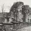
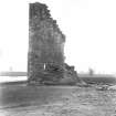
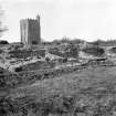
The scarcity of extant remains and the inadequacy of the documentary evidence make it impossible to say much of the architectural development of the site. No doubt a temporary church and some domestic buildings were erected soon after the Abbey was founded, but such remains as exist today suggest that the main period of building activity was in the 13th century. An extensive reconstruction seems to have been carried out in late medieval times; at the Reformation the Abbey is said toe have been "ruined and casqt down" and was soon put to use as a quarry. (See RCAHMS 1963 plans, figs.49-51).
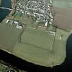
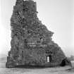
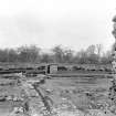
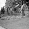
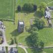
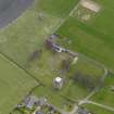
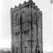
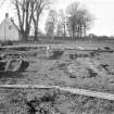
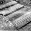
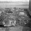
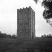
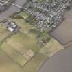
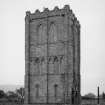
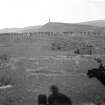
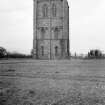
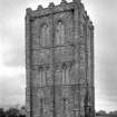
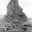
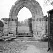
The site was excavated in 1864 under the direction of William Mackison, Town Architect of Stirling, and he restored the free-standing bell-tower at the same time. This, standing complete, is 64' (3 storeys) high. The remainder of the Abbey buildings are now mostly only foundations. The measures taken to preserve these foundations, revealed in 1864, have substantially altered their character, and much of the masonry visible today is comparatively recent. The remains include the church (the W doorway of which is still extant), a S cloister with the sacristy, slype and chapter-house on its E side, and the refectory and, probably, a kitchen on the S. On the W there was presumably a cellarium which has been destroyed; it is now merely outlined by a kerb, and its area is occupied by an orchard. To the E and SE of the cloister there are other buildings which cannot now be identified with confidence.
Close to the NE corner of the N transept of the church there are foundations which may represent the enclosing wall of a garden or orchard. The name of St James' Orchard, which lies N of the tower suggests that this ground may once have been connected with the Abbey.
RCAHMS 1963; S Cruden 1953.
Cambuskenneth (St Anrews, Linlithgow). The abbey of Cambuskenneth evidently possessed parochial staus, reference being made in 1436 to 'ecclesiae parrochialis monasterii de Cambuskynneth', the entire revenues of which would pertain to the abbey.
I B Cowan 1967.
As described.
Visited by OS(JP) 11 December 1973.
A group of 36 coins were discovered in the vicinity of the abbey in 1983.
J D Bateson 1990.
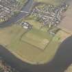
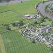
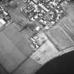
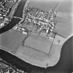
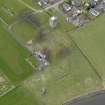
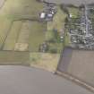
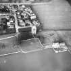
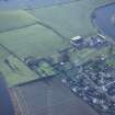
NS 808 939 During August and September 1997 topographical and resistivity surveys were undertaken in three fields and an area within the bounds of Cambuskenneth Abbey.
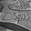
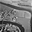
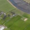
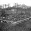
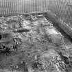
Upstanding earthworks W of the abbey ruins were recorded topographically, and a resistivity survey was undertaken in the area to test for the presence of buried remains. At least six major anomalies were detected, each coinciding with recorded topographical features. These are interpreted as building platforms with dividing trackways, associated with rubble spreads which appear to have resulted from collapsed walling. These features seem to be within the abbey precinct, and may represent the remains of buildings associated with the agricultural activities of the abbey, possibly including housing. At the W end of the field exposed walling was found, at the point where the field slopes down to the river edge. A print published in 1693 by John Slezer shows an abbey watergate at this point, and the walling may be the remains of its foundations.
Four trial trenches were opened by machine in fields S of Hood Farm. A cropmark had been observed from a 1947 vertical aerial photograph and a resistivity survey was undertaken, detecting several anomalies. The trial trenches over these anomalies and the location of the supposed cropmark found no related features, but the overploughed remains of three rig and furrow features were exposed in section, as was a single stake-hole. No datable finds were recovered.
At the request of Historic Scotland a topographical and resistivity survey was also undertaken within the scheduled area between the bank of the Forth and the eastern extent of the upstanding abbey ruins. No features of potential archaeological significance were detected. However, this result may have been affected by a high water table during the survey.
Three sub-rectangular anomalies were located immediately W of the present ruins, and it seems highly likely that they represent foundations for additional buildings associated with the abbey.
This research project was undertaken with the kind permission of the landowners, the patrons of Cowans Hospital, and Mr Andrew Rennie, the farmer.
Sponsor: Historic Scotland
D Etheridge 1997
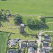
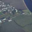
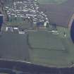
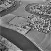
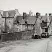
The Abbey is located at the southern end of Cambuskenneth village. The site is in the care of Historic Scotland. There are no changes to the NMR description. A 'Ruin' and structural remains, marked on the 1st ed OS map, lie outside the Abbey. The remains of the eastern and northern walls of an orchard, also seen on the 1865 map, are still visible immediately to the south of the Abbey.
Site recorded by GUARD during the Coastal Assessment Survey for Historic Scotland, 'The Firth of Forth from Dunbar to the Coast of Fife' 23 February 1996.
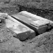
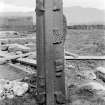
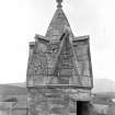
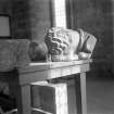
NS 8085 9396 The carved stone collection is located in the W tower of the abbey church. One of the most interesting stones forms part of a very ornate canopy, originally part of a larger design. A composition of niches with miniature vaults, and finials occupies the outer face. In addition, a large collection of cylindrical column shafts probably came from the cloister arcades. Another interesting fragment comes from the foot of a military effigy. The feet, are clad in sollerets with spurs attached, and rest on a lion. Work was undertaken on this collection between January and June 2007.
This and other inventories of carved stones at Historic Scotland’s properties in care are held by Historic Scotland’s
Collections Unit. For further information please contact at hs.collections@scotland.gsi.gov.uk.
Funder: Historic Scotland.
Architect & Mason: Alexander Mylne (Great altar and Chapter House)
EXTERNAL REFERENCE:
National Library of Scotland
Uncatalogued MSS of General Hutton
Nos 164 - 166: Engravings
Field Visit (3 June 1954)
Cambuskenneth Abbey.*
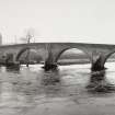
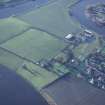
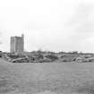
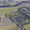
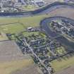
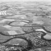
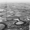
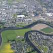
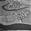
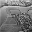
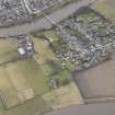
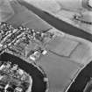
The ruins of Cambuskenneth Abbey lie on the left bank of the Forth, just opposite the NE. part of Stirling. The site is flat carseland, enclosed on three sides by a loop of the river. The monastery, which for the first half-century or so of its existence was known as the Abbey of St. Mary of Stirling, was founded in or about 1140 by David I. The community followed the Augustinian rule, but as a daughter house of the church of St. Nicholas, Arrouaise, no doubt observed the more rigorous constitutions of the order of Arrouaise for as long as the connection with the motherhouse was maintained. The endowments of the Abbey were extensive, and included not only property within Stirlingshire, but also grants of land and privileges in the counties of Perth, Angus, Fife, Aberdeen, West Lothian, Midlothian, Dunbarton and Berwick. Largely no doubt because it stood in close proximity to the Royal Castle of Stirling, the Abbey was the scene of a number of important political events. In 1314, for example, there was held at Cambuskenneth a Parliament at which all who had fought on the English side at Bannockburn and who had not come into the "faith and peace" of Robert I were forfeited; while fourteen years later, during another Parliament at Cambuskenneth, there was drawn up the well-known indenture whereby the earls, barons, burgesses and free tenants of Scotland granted a "tenth penny" to the king, In the 14th century the Abbey was frequently visited by Scottish kings, and in 1488 became the burial place of James III, who was killed during his flight from the battlefield of Sauchieburn. The most notable of the abbots of Cambuskenneth, who had received the mitre in 1406, were Patrick Pantar, Secretary to James V, and Alexander Mylne, the first President of the College of Justice. In the middle of the 16th century the Abbey passed into the hands of the Erskine family and, with the Abbey of Dryburgh and the Priory of Inchmahome, was erected into a temporal lordship for John, 2nd Earl of Mar, in 1604 and 1606.
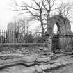
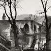
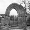
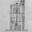
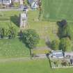
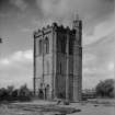
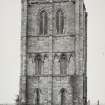
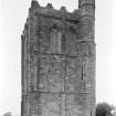
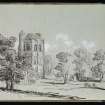
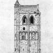
The paucity of the surviving structural remains and the inadequacy of the documentary evidence make it impossible to say much of the architectural development of the site. No doubt a temporary church and some domestic buildings were erected soon after the foundation of the Abbey, but such remains as exist today suggest that the main period of building activity lay within the 13th century. The church, now represented by. little beyond its foundations, appears to have comprised a nave with a N. aisle, a choir, transepts, each with two eastern chapels, and a short presbytery. The W. doorway of the nave remains, and may be ascribed to the first part of the 13th century; assuming that the normal building-sequence was adopted, it may be supposed that at this period the presbytery and transepts were already complete and that work was beginning upon the nave. No doubt the whole church was finished before the builders turned their attention to the free-standing bell-tower, now the most conspicuous feature of the site, which dates from the turn of the 13th and 14th centuries. Even less is known of the development of the monastic buildings, scant traces of which now survive, but if the cloister was laid out at the same time as the church, they too are likely to have been completed during the course of the 13th century.
In 1350 it was reported that the monastery had been seriously damaged by certain "diabolici homines" while in 1378 the abbot and convent stated that "their monastery had suffered from constant wars, their chalices, books, and other altar ornaments and other goods having been stolen, and their bell-tower struck by lightning, whereby the choir is greatly ruined". These complaints may have been exaggerated, and there is no architectural evidence to suggest that the bell-tower was extensively damaged at this time, but the misfortunes that were suffered by the Abbey in the latter part of the 14th century may well have made necessary the extensive scheme of reconstruction that seems to have been carried out in late mediaeval times, when the N. wall of the nave, the transept and the chapterhouse were to some extent rebuilt. A reference to the abbot's new hall in 1520 suggests that the abbot's lodgings, which appear to have been situated to the west of the main complex of monastic buildings, were reconstructed or extended at about the beginning of the 16th century. The Abbey is said to have been "ruined and cast down" at the Reformation, and the site was soon put to use as a quarry. Building materials may have been removed from Cambuskenneth for use in Mar's Work, Stirling, in about 1570, while in the 17th century the ruins provided dressed stones for Cowane's Hospital; it is said, too, that the village of Cambuskenneth is to a large extent constructed of materials obtained from this source.s Slezer's view of about 1693 suggests that considerable remains of the church still existed in his day, but by the time that Grose visited the site, a century later, there was nothing to be seen "except a few broken walls, the bell tower, and staircase. . . ; some remains of the garden are also to be seen, and the burial place of K. James and his Queen: no traces of the church remain".
In 1864 the site was excavated under the direction of William Mackison, Town Architect of Stirling, who prepared a detailed and well-illustrated report of the excavations together with an account of the restoration of the bell-tower, which was carried out to his specifications at about the same time. Not all the excavator's conclusions are acceptable, but the report is a valuable one and has been extensively used in the preparation of the following architectural description. In 1908 the site was acquired by the Crown, and it is now under the guardianship of the Ministry of Works.
RCAHMS 1963, visited 3 June 1954.
*See RCAHMS 1963, 120-129 for the full account with illustrations and references of which this is the introductory paragraphs.
Field Visit (August 1978)
Cambuskenneth Abbey NS 808 939 NS89SW 4
Apart from a heavily restored bell-tower very little of this Augustinian abbey now survives. It was founded about 1140 but the visible remains suggest that the main period of building activity was in the 13th century.
RCAHMS 1979, visited August 1978
(RCAHMS 1963, pp. 120-9, no. 130; Cowan and Easson 1976, 89-90)
Publication Account (1985)
The ruins of this abbey, fonnerly known as the Abbey ofSt Mary of Stirling, lie in a bend of the Forth and are overlooked by the major medieval castle and town of Stirling. Founded in c 1147 by David I (c 1084-1153), the abbey was a daughter house of the French Augustinian monastery of St Nicholas at Arras and, because of its proximity to the royal castle at Stirling, it was the setting for a number of important historical events, which included meetings of Parliament in the 14th century and a visit by Edward I of England in 1303-4. During the Wars ofIndependence (1296-1357), the abbey suffered structural damage and was pillaged of much of its furniture and treasure. In 1559 the abbey was dissolved and the buildings were subsequently used as stone quarries for Stirling-some of the stone being removed to build Mar's Work (no. 12) and Cowane's Hospital (no. 13).
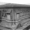
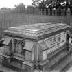
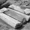
Although founded in the mid 12th century, the main period of construction did not take place until late in the following century when a cruciform church flanked on the south by a cloister, chapter-house and refectory were built These have now been reduced to little more than their foundations, and much of what can be seen today is the result of reconstruction during the 19th century. In the course of excavations in 1865 what are believed to have been the coffins of James III (died 1488) and his queen, Margaret of Denmark, were found near the high altar. The royal remains were subsequently reburied at the expense of Queen Victoria, and the new tomb can be seen on the site of the fonner high altar.
The best-preserved, but heavily restored, part of the abbey is the bell-tower, which lies to the north-west of the church. It is the only surviving example from medieval Scotland of a free-standing belfry-a type of building more familiar in Italy. The tower was probably erected some time after the church and abbey buildings but its precise date of construction is unknown.
Information from ‘Exploring Scotland’s Heritage: The Clyde Estuary and Central Region’, (1985).
Watching Brief (27 August 2012 - 14 September 2012)
NS 8086 9394 A watching brief was carried out on 30 April 2013 during the excavation of a trench to install a new sign. Upper deposits and the finds found within them suggested that they consist of made ground of imported material. More interesting is the discrete layer of clay below, which has been deliberately deposited, and possibly relates to the installation of the graveyard behind. This sits at a higher level than the bank, and is in turn higher than the soft deposits which currently cover the floor of the nave. It is also worth noting that clay linings are also used in garden parterres.
Archive: RCAHMS (intended)
Funder: Historic Scotland
Paul Fox, Kirkdale Archaeology, 2013
(Source: DES)
Fabric Recording (October 2015)
NS 8085 9398 A survey of the stonemasons’ marks on the walls of the Bell Tower of Cambuskenneth Priory was undertaken over three days in October 2015 by the Masons’ Mark Project, with the help of two volunteers, after receiving permission from Historic Scotland to undertake the survey.
All internal walls and ribbed vaulting on the ground floor, the two upper floors and spiral stair within the tower were carefully checked for marks. None was noted on the exterior, but this was most likely due to loss through weather erosion of the stone. A total of 497 marks were recorded belonging to 86 different masons.
From the recording and subsequent study of the stonemasons’ marks it is fairly evident that at least three different phases of building were undertaken, although how long a period between them is not clear. There is a definite group of 32 masons who only worked on the ground floor, which includes the area at the bottom of the stairs. Of these 32 masons, four of them worked only on the ribbing of the roof vault, with six of the others also working on the ribbing as well as the walls. Only three masons from this group carrying on to work on the 1st floor, although five of the others did some work on the
spiral stair. Another different group of 25 masons’ marks were recorded on the 1st floor walls, some of whom also worked on the spiral stair. There is also then a group of nine masons who only worked on the spiral stair. However, from the recording work it is fairly obvious that something changes above the 26th course of the 1st floor, as no marks are recorded above it, which goes up to 38 courses. This continues on the 2nd floor where only one possible mark
was found on one wall, with two possible later marks or graffiti. A group of 12 later masons’ marks are scattered throughout the building, but they do not give much idea of repairs undertaken, as some are marked on blocks that have earlier marks on them.
Report: Historic Environment Scotland and Stirling Council Archaeology Service
Report: www.masonsmarkproject.org.uk
Moira Greig – Mason’s Mark Project
(Source: DES, Volume 17)
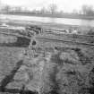
Test Pit Survey (9 September 2015 - 10 September 2015)
A programme of archaeological test pitting was required by the Central Scotland Green Network Trust at Cambuskenneth Abbey, Stirling, as part of the wider project to re-create part of the Tower orchard at Cambuskenneth Abbey. The site lies outwith the Scheduled Monument area of Cambuskenneth Abbey, although Historic Scotland have requested that a test pitting exercise be undertaken to assess the archaeological potential of the site. From there, Historic Scotland will determine whether any further archaeological works are required prior to any further on-site works as part of the overall project. The test pitting revealed a relatively uniform soil matrix across the site, with the natural only being uncovered in two of the pits. Overall the most archaeologically significant deposit was a greyish-brown sandy-silty clay deposit with a high frequency of small finds, including oyster shell and ceramics. Two of the test pits revealed potential building materials and a cobbled surface. An archaeological watching brief is therefore recommended to observe the areas where trees are being reinstated.
Information from Nicholas Johnstone (AOC Archaeolog Group) 1 march 2016. OASIS ID: aocarcha1-223455

