
Pricing Change
New pricing for orders of material from this site will come into place shortly. Charges for supply of digital images, digitisation on demand, prints and licensing will be altered.
Tamfourhill


Temporary Camp (Roman)
Site Name Tamfourhill
Classification Temporary Camp (Roman)
Alternative Name(s) Antonine Wall; Falkirk; Station House
Canmore ID 46750
Site Number NS87NE 13
NGR NS 8594 7946
NGR Description Centred NS 8594 7946
Datum OSGB36 - NGR
Permalink http://canmore.org.uk/site/46750


- Council Falkirk
- Parish Falkirk
- Former Region Central
- Former District Falkirk
- Former County Stirlingshire
NS87NE 13 centred 8594 7946.
NS 859 794. There is a Roman temporary camp at Tamfourhill.
Information from RCAHMS, letter dated 11 October 1977.
RCAHMS APs (flown in 1977) show cropmarks of the almost entire circuit of a Roman temporary camp. It measures about 200m N-S by 140m. E-W, and there are well defined entrances in the N and S arms.
There is no surface trace of this camp on a gently undulating plateau under light pasture.
Surveyed at 1:2500 and 1:1250.
Visited by OS (JRL), 25 April 1980.
Possible labour camp for wall construction. Measures about 185m from N to S by 150m transversely, and about 2.8ha in area.
G Maxwell and D R Wilson 1987.
NS 85 79 Archaeological investigations were undertaken prior to construction works associated with the Falkirk Millennium Link Project.
NS 8595 7955 A putative tutulus to Tamfourhill Roman temporary camp (NMRS NS87NE 13). As the feature was unaffected by canal construction works, it was not excavated.
Sponsor: Morrison Construction Ltd.
J Gooder and A Duffy 2000.
Scheduled as 'Station House, Roman temporary camp 200m SE of... the buried remains of a Roman temporary camp...'
Information from Historic Scotland, scheduling document dated 25 June 2010.
Aerial Photography (30 July 1977)
Field Visit (25 April 1980)
There is no surface trace of this camp on a gently undulating plateau under light pasture.
Surveyed at 1:2500 and 1:1250.
Visited by OS (JRL) 25 April 1980
Aerial Photographic Transcription (3 February 1998)
An aerial transcription was produced from oblique aerial photographs. Information from Historic Environment Scotland (BM) 31 March 2017.
Excavation (23 November 2000 - 27 November 2000)
NS 85 79 Archaeological investigations were undertaken prior to construction works associated with the Falkirk Millennium Link Project.
NS 8595 7955 A putative tutulus to Tamfourhill Roman temporary camp (NMRS NS 87 NE 13). As the feature was unaffected by canal construction works, it was not excavated.
Sponsor: Morrison Construction Ltd
J Gooder and A Duffy 2000
Archaeological Evaluation (2000)
NS 85 79 Archaeological investigations were undertaken prior to construction works associated with the Falkirk Millennium Link Project.
NS 8583 7959 Two sections of a 6m wide cobbled road surface, aligned E-W and of unknown date, were located either side of a small wooded ravine.
Sponsor: Morrison Construction Ltd.
J Gooder and A Duffy 2000
Publication Account (2008)
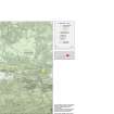
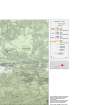
A 1:25000 scale map of the Antonine Wall was published by RCAHMS in 2008. The map shows the course of the Antonine Wall on a modern map base, including areas where the Wall is in public ownership or care and can be visited. The data had been collated as part of the project to prepare maps for the World Heritage Site nomination bid.
Publication Account (17 December 2011)
The camp at Tamfourhill was discovered as a cropmark from the air by Maxwell in 1977 (Maxwell and Wilson 1987: 29), lying in a field just to the south of the village of T amfourhill, between the Edinburgh to Glasgow railway line and Tamfourhill Wood. The field slopes gently downwards towards the north with the camp lying about 300m south of the Antonine Wall, and about 400m southwest of the fortlet at Watling Lodge. The camp measures about 190m from NNE to SS W by 140m transversely, enclosing an area of some 2.7ha (6.7 acres). Entrance gaps with tituli have been recorded in the centre of the NNE and SS W sides, and to the north of centre on the ESE side, suggesting that the camp faced NNE towards Watling Lodge.
The new canal extension for the Falkirk Millennium Link Project, linking the Union Canal with the Forth and Clyde Canal, skirts around the north side of the camp. The titulus on the NNE side was recorded during the construction works, but not excavated (Gooder and Duffy 2000).
R H Jones.

