
Pricing Change
New pricing for orders of material from this site will come into place shortly. Charges for supply of digital images, digitisation on demand, prints and licensing will be altered.
Mountcow


Ironstone Mine (19th Century)(Possible)
Site Name Mountcow
Classification Ironstone Mine (19th Century)(Possible)
Canmore ID 46741
Site Number NS86SW 6
NGR NS 825 643
Datum OSGB36 - NGR
Permalink http://canmore.org.uk/site/46741


- Council North Lanarkshire
- Parish Shotts (Monklands)
- Former Region Strathclyde
- Former District Monklands
- Former County Lanarkshire
Note (13 May 1939)
NS86SW 6 825 643
Remains of old ironstone workings.
Information O G S Crawford, 13 May 1939.
Field Visit (7 September 1992)
NS86SW 6 825 643
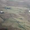
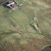
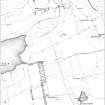
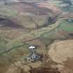
The remains of what may have been an ironstone mine (CSW 4057) are situated in rough pasture to the W of Mountcow farmsteading, and comprise a large crow's foot bing with two smaller bings on the E, as depicted on the current edition of the OS 1:10,000 map (1981). A boggy hollow, which may mark the location of the pit-head, lies between the three bings, with a possible horse-engine platform on the N. The farm track runs along the line of a railway which had been dismantled by the 2nd edition. The mine is not depicted on the 1st edition of the OS 6-inch map (Lanarkshire 1859, sheet viii) and appears to have gone out of use by the date of the 2nd edition of the OS 6-inch map (Lanarkshire, 1899, sheet viii). Two further bings (CSW 4056 and 4058) to the NW and W may have been associated with the mine and are also depicted on the 2nd edition map (ibid).
(CSW 4056-58)
Visited by RCAHMS (DCC) 7 September 1992

