|
Manuscripts |
MS 731/11 |
Records of the Royal Commission on the Ancient and Historical Monuments of Scotland (RCAHMS), Edinbu |
Printout of RCAHMS Afforestable Land Survey field database (Central Scottish Woodlands) - See DX001418.csv for a digital copy |
1992 |
Item Level |
|
|
Photographs and Off-line Digital Images |
B 97345 CS |
RCAHMS Aerial Photography |
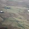
Blackhill and Mountcow, oblique aerial view, taken from the N, showing Blackhill enclosures in the bottom left-hand corner of the photograph, and Mountcow ironstone mine in the centre, to the right of Mountcow farmstead. |
1995 |
Item Level |
|
|
Photographs and Off-line Digital Images |
B 97349 CS |
RCAHMS Aerial Photography |
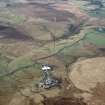
Mountcow, oblique aerial view, taken from the NW, showing Mountcow ironstone mine in ther centre of the photograph. |
1995 |
Item Level |
|
|
Photographs and Off-line Digital Images |
B 97353 CS |
RCAHMS Aerial Photography |
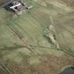
Blackhill and Mountcow, oblique aerial view, taken from the E, showing Blackhill enclosures in the bottom right-hand corner of the photograph, and Mountcow ironstone mine at the left-hand edge. |
1995 |
Item Level |
|
 |
On-line Digital Images |
SC 1519272 |
RCAHMS Aerial Photography |
Blackhill and Mountcow, oblique aerial view, taken from the N, showing Blackhill enclosures in the bottom left-hand corner of the photograph, and Mountcow ironstone mine in the centre, to the right of Mountcow farmstead. |
1995 |
Item Level |
|
 |
On-line Digital Images |
SC 1519275 |
RCAHMS Aerial Photography |
Mountcow, oblique aerial view, taken from the NW, showing Mountcow ironstone mine in ther centre of the photograph. |
1995 |
Item Level |
|
 |
On-line Digital Images |
SC 1519277 |
RCAHMS Aerial Photography |
Blackhill and Mountcow, oblique aerial view, taken from the E, showing Blackhill enclosures in the bottom right-hand corner of the photograph, and Mountcow ironstone mine at the left-hand edge. |
1995 |
Item Level |
|
|
Digital Files (Non-image) |
DX 001418 |
Records of the Royal Commission on the Ancient and Historical Monuments of Scotland (RCAHMS), Edinbu |
RCAHMS Structures Database, Central Scotland Woodland |
1992 |
Item Level |
|
 |
On-line Digital Images |
SC 2031901 |
Records of the Royal Commission on the Ancient and Historical Monuments of Scotland (RCAHMS), Edinbu |
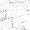
Publication illustration: 'Extract from the first edition of the OS 6-inch map, showing the area to the west of Mountcow Farmsteading, Shotts (Lanarkshire 1864, sheet viii, surveyed 1859). |
1998 |
Item Level |
|
|
Digital Files (Non-image) |
TM 000316 |
Records of the Royal Commission on the Ancient and Historical Monuments of Scotland (RCAHMS), Edinbu |
ZIP file containing dxf data sets used to create illustrations for Forts, Farms and Furnaces, Archaeology in the Central Scotland Forest, RCAHMS 1998 (WP003896.pdf) along with dxf files of survey overlays. |
1992 |
Item Level |
|
 |
On-line Digital Images |
SC 2432023 |
Records of the Ordnance Survey, Southampton, Hampshire, England |
Mountcow, NS86SW 6, Ordnance Survey index card, Recto |
1958 |
Item Level |
|
|
Digital Files (Non-image) |
TM 002211 |
Records of the Royal Commission on the Ancient and Historical Monuments of Scotland (RCAHMS), Edinbu |
ZIP file containing all survey linework collected as part of the RCAHMS survey of Central Scotland Woodland area. SHP and Geojson file formats with extra attribution added to the linework. |
1992 |
Item Level |
|


