Accessibility

Font Size

100% 150% 200%

Background Colour

Default Contrast
Close Reset

Lanark, Hyndford Road, St Kentigern's Church

Burial Ground (17th Century), Church (Medieval)

Site Name Lanark, Hyndford Road, St Kentigern's Church

Classification Burial Ground (17th Century), Church (Medieval)

Alternative Name(s) Old Parish Church; Churchyard

Canmore ID 46576

Site Number NS84SE 15

NGR NS 88787 43246

Datum OSGB36 - NGR

Permalink http://canmore.org.uk/site/46576

Ordnance Survey licence number AC0000807262. All rights reserved.
Canmore Disclaimer. © Bluesky International Limited 2025. Public Sector Viewing Terms

Toggle Aerial | View on large map

Digital Images

Scanned image of drawing showing church ruins from North.
Scanned image of drawing showing church ruins from North.Detaill of Covenanter's gravestone within the burial ground to the south east of the churchOblique aerial view of St Kentigern's Church Lanark, taken from the ENE.Oblique aerial view of St Kentigern's Church Lanark, taken from the SSE.Oblique aerial view of Lanark Grammar School and St Kentigern's Church, looking to the ENE.St Kentigern's Church, Lanark, South LanarkshirePhotographs and research notes relating to graveyard monuments in St Kentigerns Churchyard, Lanarkshire. 
St Kentigern's Church. View from North.St Kentigern's Church. Detail of pre-Reformation stone reset in wall.Drawing of church ruins from South.Detail of Round headed and T shaped stones within the burial ground to the south east of churchView of John Orr monument adjacent to south wall of churchView of west wall of the church, taken from south westView looking across the burial ground to the N side of the church, taken from the north westSt Kentigern's Church. View from South-West.Photographs and research notes relating to graveyard monuments in St Kentigerns Churchyard, Lanarkshire. 
View of grave-stone.
Digital image of LA 3769/2View of doorway within south wall of church, taken from south westDetail of Covenanter's gravestone within the burial ground to the south east of the churchView of west wall of the church, taken from the west north westOblique aerial view of St Kentigern's Church Lanark, taken from the SSW.Drawn detail of doorway and view from South East.Oblique aerial view of Lanark Grammar School and St Kentigern's Church, looking to the NNE.Oblique aerial view of Lanark Grammar School and St Kentigern's Church, looking to the N.St Kentigern's Church. View of South door of nave.St Kentigern's Church. Detail of East capital of nave.Photographs and research notes relating to graveyard monuments in St Kentigerns Churchyard, Lanarkshire. 
St Kentigern's Church. View of arcade.View of grave-stone.
Digital image of LA 3769/1Drawing of church ruins from North.Detail of skull and crossbones and winged hour glass on gravestone to the south of the churchDetail of gravestone for David Craig, within the burial ground to the south west of the churchView of west door, with blocked openings above, taken from west north westOblique aerial view of St Kentigern's Church Lanark, taken from the S.Oblique aerial view of St Kentigern's Church and Lanark Grammar School, looking to the S.Oblique aerial view of St Kentigern's Church and Lanark Grammar School, looking to the SE.Oblique aerial view of St Kentigern's Church and Lanark Grammar School, looking to the SSW.St Kentigern's Church. View of window in nave.St Kentigern's Church. General view from South.St Kentigern's Church. View from North.St Kentigern's Church. View of arcade.Aerial view.View of doorway, St Kenitgern's Church, Hyndford Road, Lanark, South LanarkshireLanark, Hyndford Road, St Kentigern's Church, NS84SE 15, Ordnance Survey index card, page number 1, RectoSt Kentigern's Church. View of South door of nave.St Kentigern's Church. View of window in nave.St Kentigern's Church. View from South-West.Drawing of church ruins from West.Oblique aerial view of Lanark centred on the cemetery, taken from the E.Detail of east carved capital on south doorway of churchOblique aerial view of St Kentigern's Church and Lanark Grammar School, looking to the NW.St Kentigern's Church. Detail of hog backed stone reset over West door.Aerial view.Photographs and research notes relating to graveyard monuments in St Kentigerns Churchyard, Lanarkshire. 
St Kentigern's Church. Detail of East capital of nave.View of arcade.Scanned image of drawing showing church ruins from South.View of arcade from South-East.General view looking the north arcade of the church, taken from the west north westOblique aerial view of St Kentigern's Church Lanark, taken from the NW.Oblique aerial view of St Kentigern's Church Lanark, taken from the SW.Oblique aerial view of St Kentigern's Church Lanark, taken from the S.Oblique aerial view of Lanark Grammar School and St Kentigern's Church, looking to the E.Oblique aerial view of Lanark Grammar School and St Kentigern's Church, looking to the NE.Oblique aerial view of St Kentigern's Church and Lanark Grammar School, looking to the S.St Kentigern's Church. View from West.Aerial view.Lanark, Hyndford Road, St Kentigern's Church, NS84SE 15, Ordnance Survey index card, RectoLanark, Hyndford Road, St Kentigern's Church, NS84SE 15, Ordnance Survey index card, RectoSt Kentigern's Church. Detail of hog backed stone reset over West door.View of grave-stone.
Digital image of LA/3769/3Detail of angel carving to head of John Orr monument, adjacent to the south wall of the churchOblique aerial view of St Kentigern's Church Lanark, taken from the N.Oblique aerial view of St Kentigern's Church Lanark, taken from the NNE.Oblique aerial view of St Kentigern's Church Lanark, taken from the W.St Kentigern's Church, Lanark, South LanarkshireSt Kentigern's Church. View from West.Scanned image of drawing showing church ruins from West.Detail of west carved capital on south doorway of church.Detail of Round headed and T shaped gravestones within the burial ground to the south east of the churchOblique aerial view of St Kentigern's Church and Lanark Grammar School, looking to the ESE.St Kentigern's Church. Detail of pre-Reformation stone reset in wall.St Kentigern's Church. General view from South.

Administrative Areas

  • Council South Lanarkshire
  • Parish Lanark
  • Former Region Strathclyde
  • Former District Clydesdale
  • Former County Lanarkshire

Archaeology Notes

NS84SE 15 88787 43246

(NS 8878 4325) St Kentigern's Church (NR) (Ruin)

OS 6" map (1941)

The ancient Parish Church of Lanark was dedicated to St Kentigern and was granted in 1150 by David I to the monastery at Dryburgh, with whom it remained until the Reformation. The architecture of the present church is 13th century and the site is known to have been occupied by a previous church.

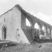
The building was in ruins by the middle of the 18th century, and in 1834 consisted of six fine Gothic arches supporting a wall which seems to have separated the body of the church from a side aisle, along its whole length.

NSA 1845 (W Menzies); G V Irving and A Murray 1864; G Chalmers 1890.

The remains of the church consist of the six arches and east, west and south walls, the latter containing lancet windows. The six arches fell in 1954, and were rebuilt that year.

Visited by OS (JFC) 25 March 1955

Activities

Publication Account (1981)

Lanark's earliest parish church was located about a quarter of a mile (0•4km) south-east of the town on the Stirling to Carlisle road. Shortly after the Reformation the Kirk session tried to have the location of the parish church changed to a more convenient place, although this was not accomplished until towards the beginning of the eighteenth century. The parish church of St. Kentigern fell into ruin in 1688 and in 1709 a proposal to rebuild it was stopped by the town council and the chapel of St. Nicholas was taken over for use as a parish church. The remains of St. Kentigern's consists of a north arcade, six arches, and west, east and south walls, the latter consisting of six lancet windows and a first period lancet doorway. The six arches fell in 1954, but were rebuilt that year (Ordnance Survey Record Cards, Reference NS 84 SE 15).

Information from ‘Historic Lanark: The Archaeological Implications of Development’ (1981).

References

MyCanmore Image Contributions


Contribute an Image

MyCanmore Text Contributions