
Forth And Clyde Canal, Craigmarloch Canal Stables


Stable(S) (19th Century)
Site Name Forth And Clyde Canal, Craigmarloch Canal Stables
Classification Stable(S) (19th Century)
Alternative Name(s) Croy Hill
Canmore ID 45913
Site Number NS77NW 44
NGR NS 7371 7753
Datum OSGB36 - NGR
Permalink http://canmore.org.uk/site/45913


- Council North Lanarkshire
- Parish Kilsyth (North Lanarkshire)
- Former Region Strathclyde
- Former District Cumbernauld And Kilsyth
- Former County Stirlingshire
NS77NW 44 7371 7735
See also NS77NW 53.
For (nearby) drawbridge (bascule bridge) over the canal, see NS77NW 43.
This stable-block, like that at Shirva (NS67NE 16) and elsewhere, had a two-storeyed and hipped-roof main block with an advanced and pedimented central bay. The functionally handsome appearance of these buildings echoes the more elegant treatment accorded to the classical Canal Office (NS56NE 86) on the North Speirs Wharf at Port Dundas.
G D Hay and G P Stell 1986.
NS77NW 44 NS 7371 7753.
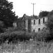
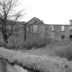
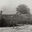
This stable block, which formerly housed the horses used for towing boats in this section of the canal, is now in ruins.
RCAHMS 1963.
These stables, built to a standard pattern, are located at some distance from the canal. As the canal builders discovered to their cost, when the first block they built sank, the land near the canal was too boggy to support a building of the size required.
The Forth and Clyde Canal Guidebook 1991.
This former stables block, a large building with windows now boarded up, is situated at some distance to the N of the Craigmarloch Bridge. As the first stable block disappeared into the boggy ground, these stables were constructed at a location a distance away from the canal.
H Brown 1997.
The stables are clearly marked on the 1st edition of the OS 6-inch map (Stirlingshire 1865, sheet xxix) and can also be located on the current edition of the OS 1:10000 map (1990).
Information from RCAHMS (MD) 10 October 2000.
2-storey, 7-bay, Symmetrical rectangular-plan, former stable building in classical style with central pediment with blind oculus sited near a former basin of the Forth and Clyde Canal. The stables are a consolidated ruin complete to wallhead constructed of droved buff sandstone ashlar with rubble to sides and back. The building has margined quoins, segmental-headed openings (most bricked up) with raised margins, stone cills and continuous eaves cornice capping. Central entrance door with doors to penultimate left and far right bays. Single door to east elevation and two small windows to rear elevation (lower open).
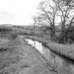
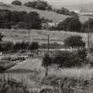
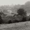
Craigmarloch Stables is an example of the style of classical stable building designed in the early 19th century specifically for the Forth and Clyde Canal which is the oldest and longest canal in Scotland. The stables at Craigmarloch, which are roofless, are an integral and surviving part of this historic canal system. Hume describes them as the 'standard' stable design for the canal, other examples of which exist at Lambhill and Glasgow Bridge (see separate listings). There are a small number of stable blocks, constructed in the 1820s-30s along the length of the canal to coincide with the introduction of fast passenger boats (swifts), for which they provided fresh horses at regular intervals of around 6.5 to 7.5 kilometres. Each stable fulfilled the same function, providing a house for a stable keeper, stall accommodation for horses and a hay store above. The stable network on the canal included a small number of nonstandard stable designs at Underwood, Wyndford and Lock 16 towards the east end of the canal which was built first. The 'standard' classical stables were built after the completion of the canal in 1790, in some instances superseding the earlier stable blocks, and in a similar style to the Forth and Clyde offices at Port Dundas (circa 1812, see separate listings). The stables are located on raised ground adjacent to the canal feeder which runs south on an aqueduct over the Dullatur Bog to join the canal. During the construction of the canal in the late 18th century the bog became an engineering challenge when the engineering works and first newly built stables slid into the bog shortly after construction. The current stables were a replacement and built on higher, sound ground some distance from the canal. The canal, feeder, and a number of other associated structures are a Scheduled Monument. See Scheduled Monument No 6766 for full details. The Forth and Clyde Canal is the oldest and the longest canal in Scotland completed in 1790. The idea to link the east and west coasts of Scotland by a waterway was to avoid the difficult sea trade route around the north coast and was first considered in the reign of Charles II (1660-85). Surveys were carried out in 1726, 1762 and then in 1763-4 by Yorkshire Engineer John Smeaton (1724-1792) who proceeded to design and oversee its first stage of construction. First called the Great Canal it was an impressive feat of engineering at 38.75 miles long and rising to 156 feet above sea level near the centre through 20 locks to the east side and 19 to the west. The building of the canal was authorised by an Act of Parliament in 1768 with an estimated cost of £150,000. Construction began under Smeaton at the east coast in June 1768 but financial difficulties by 1775 meant that it stalled at the east side of Glasgow. Robert Mackell took over as the principal on-site engineer in 1777 but work stalled again and was not resumed until 1785 when a government grant of £50,000 allowed work to continue under Robert Whitworth (1734-1799). Whitworth was an experienced canal engineer from England who managed the project until completion when it opened to trade in July 1790. In 1791 the 3 mile branch link into central Glasgow at Port Dundas was opened. The water for the canal was provided to the highest point by the Townhead Reservoir near Kilsyth and later by the Monkland Canal. As the canal was designed to link the two coasts it had to carry seagoing vessels. As a result of this it was relatively large at 2.4 metres deep and 19.2 metres wide in most places, and all the bridges were designed to clear the waterway to allow boat's masts to pass through. The bridges were first built as timber 'drawbridge' designs but by the 19th century these had been replaced by timber and cast-iron 'bascule bridges' which worked like a drawbridge and were lifted by hand-operated gearing. The two most major engineering projects were the aqueducts; the single-arched Kirkintilloch example by Smeaton of 1772, and the four-arched Kelvin viaduct by Whitworth of 1787-9. The latter was the largest engineering work of its kind in Britain when built. The canal became an integral element in the industrial landscape in Scotland until 1840 onwards when there was a significant drop in income for the canals with the introduction of the railways. The Canal had other subsidiary business interests which continued after its usage declined such as providing waste water to local industries and even to the railways who had become their main competitors in the later 19th century. A subsequent Act of Parliament in 1867 authorised the sale of the Forth and Clyde and the Monkland Canal to the Caledonian Railway, who ran both transport systems until the railway became more profitable and the canals less used. The Forth and Clyde canal was closed in 1963 due to lack of use and lay unused until 2002 when it was reopened following the 'Millennium Link Project', a major refurbishment scheme costing £84 million which required re-dredging the canal and raising the height of later road bridges. The project also reconnected the Forth and Clyde and Union Canals by designing the 'Falkirk Wheel' a major engineering project and the world's first and only rotating boat lift. The wheel was built to replace the 11 locks at Camelon, which were dismantled in 1933, by rotating the boats in paired gondolas to raise or lower them 35 metres. The canal is now used primarily by the leisure and tourist industry. The stables are within the boundaries of the Scheduled Ancient Monument but are excluded from the scheduling and within the Antonine Wall Buffer Zone. Previously listed as 'Kilsyth, Forth and Clyde Canal, Craigmarloch Stables'. Currently roofless (2013). Listed building record updated and category changed from B to C as part of Scottish Canals Estate Review (2013-14). (Historic Scotland)
NS 73706 77528 (Canmore ID: 45913) Archaeology Scotland conducted a programme of archaeology work, 3 November 2014 – 24 March 2015, at Craigmarloch Stables in partnership with Scottish Canals and the Scottish Waterways Trust as part of their Canal College Project.
The stable block once served as a home for the stable master and his family, and would house up to eight horses at a time, responsible for towing canal boats along the Forth and Clyde Canal. The stable block was one of several stable blocks, constructed in the 1820–30s, to coincide with the introduction of fast passenger boats (swifts), for which they provided fresh horses at regular intervals of c6.5–7.5km. There is a series of ruinous buildings to the E of the stable block that would have originally been a series of single storey cottages, which are reported to have been
demolished in the 1960s following the closure of the canal. The project represents one part of a wider program of works as part of the Canal College Project to provide skills training to participants. A programme of vegetation clearance was carried out at the stable block, along with a conservation workshop in lime mortaring and a basic survey for the series
of buildings present.
Archive and report: NRHE (intended)
Funder: HLF, HES and Scottish Waterways Trust
Cara Jones and Alan Forester – Archaeology Scotland
(Source: DES, Volume 17)
Linear Account
NMRS Collection:
Microfiche material and photographic prints copied from 'The Civil and Mechanical Engineering Designs of John Smeaton, FRS', Volumes 5 and 6: Canal Works; Sluices and Harbours'.
Folios and loose sheets relating to the forth and Clyde Canal Project, 1768- (Copyright/permission to reproduce: The Royal Society). Original material held in the archives of The Royal Society, London.
NMRS reference numbers E 10904 - E 10971
History.
This sea to sea canal was one of three constructed in Scotland in this period, the other two being the Caledonian and Crinan Canals. It was the first to be started and was the most successful of them. The proposal to link the firths across the narrow isthmus was a fairly obvious one and had been made on a number of occasions, commencing in the time of Charles II, when it was viewed as a possible passage for warships. Defoe raised the issue in his Tour (Defoe, 1724-6), noting the trading advantages it would bring and the ease of its construction. Surveys were undertaken in 1723 and 1761, but no action ensued.
The construction of the Bridgewater Canal near Manchester in 1761 began a commercial craze for canals. When commerce began to apply pressure for a scheme in the Forth/Clyde area, some forty years later, three distinct camps emerged. Firstly, there were those who were interested in Scotland's general prosperity. They were represented by the Board of Trustees for the Encouragement of Fisheries, Manufactures and Improvements in Scotland. Secondly, there were the Glasgow merchants, who were anxious to have trade centred on their city, and so wished to gain the trade of the E coast, which was essentially with Europe. A third group wanted a canal routed via Loch Lomond.
Smeaton (1724-92), the greatest civil engineer of his time in Britain, penned a report in 1763 for the Board of Trustees, which included estimates for a seven foot or five foot deep canal, running from the Carron to the Kelvin and linking with the Clyde at Yoker, thus basically not serving Glasgow. However, the Glasgow interests hired Robert Mackell and James Watt to make surveys for a four foot deep barge canal. When a Bill was introduced into Parliament seeking to authorise the latter scheme, protest meetings were held in Edinburgh, Perth and Aberdeen and petitions presented to Parliament. A subscription was raised for a deeper canal, preferably of nine feet draught, but a compromise was reached and approved by the Convention of Royal Burghs in 1767. In March 1768 the Act of Parliament (8 Geo.III, cap.63) was passed, enabling the Proprietors of the Forth and Clyde Navigation, the title of the company involved, to construct the canal. The preamble to the Act refers to it as a "navigable Cut or Canal" which would "open an easy Communication between the Firths of Forth and Clyde, as also between the interior Parts of the Country, which will not only be a great Advantage to the Trade carried on between the said two Firths, but will also tend to the Improvement of the adjacent Lands, the Relief of the Poor, and the Preservation of the public Roads, and moreover be of general Utility." Authorisation was given to the proprietors to take water from the Carron, Endrick and Kelvin Rivers, as well as from all lochs and rivers within ten miles of the new waterway, as long as water-supply to the mills on the Carron and Kelvin was not diminished. It was regarded as a prestigious piece of engineering, and the proprietors included four dukes, including the Duke of Queensberry as Chairman, six earls, the Provosts of Edinburgh and Glasgow and Sir Lawrence Dundas, whose estate straddled the proposed entry of the canal from the Forth.
Work began in June 1768 on a seven foot deep waterway, with a branch to Glasgow of the same depth. Whitworth increased the depth to eight feet and later it was increased to nine feet. The channel, twenty seven feet wide at the base, widened out to fifty six feet in width at the top. Construction work included making the canal watertight with clay puddle, and building locks (seventy feet long and twenty feet broad, with a rise of eight feet), embankments, culverts, sluices, aqueducts and bridges where required. Reservoirs and feeder channels supplied water, and a towpath, wharves, basins, stables for horses and houses for lock-keepers or other employees were also constructed. The planned route (a suggestion made by Smeaton to route it via Loch Lomond was regarded as too expensive) was via the Carron River near its entry to the Forth, constructing a first lock at the Grange Burn and then following the valleys of the Bonny and Kelvin Rivers as far W as Stockingfield (Maryhill), a point three miles from Glasgow. Originally it was proposed to terminate the canal in the W at Dalmuir Burn, but later a decision was taken to make Bowling Bay the terminus. Despite differences of opinion over exact routing in certain sections, including the entry at the East, work progressed steadily. By 1773, when water was first let into it, the canal, commenced in the E, had reached Kirkintilloch, goods for or from Glasgow using carts for the rest of the journey, and by 1775, it was completed as far as Stockingfield. At that stage, funds were exhausted, but Glasgow raised the necessary capital for the branch to the city, thus improving the commercial prosperity of that city while leaving the rest of Scotland frustrated.
John Knox then wrote a book advocating the completion of the canal to the W coast, on the grounds of it being advantageous to Scottish trade. The Government replied by advancing #50,000 to the company in 1784, utilising funds from forfeited Jacobite Estates and work was recommenced, taking the canal to Bowling on the Clyde, the engineer then employed being Robert Whitworth in place of Smeaton. His work included the four-arched aqueduct which took the canal seventy feet above the River Kelvin at Maryhill. The first vessel completed the Forth to Clyde passage in August, 1790, sailing from Leith to Greenock. The Glasgow branch was simultaneously extended to the new 'village' of Port Dundas, named after the governor of the canal company, Lord Dundas. The construction included twenty locks in the eastern section and nineteen in the west, a height of one hundred and fifty six feet above sea level being reached in the centre and the whole waterway measuring thirty-eight and three quarter miles in total.
The prosperity of the canal, a waterway thirty-five miles in length with an additional three and a half in the Glasgow branch, gradually increased. As well as providing a shorter and less dangerous journey between the East and West coasts for sea-going vessels, it furnished a commercial avenue for Central Scotland, conveying goods of all types, including coal, timber, iron, tin, copper, earthenware, beef, pork, flour, barley, wine sugar, tobacco and textiles, and from 1783, it carried passengers. Separate passenger boats were instituted in 1809, it being recognised that these provided a smooth and comfortable form of conveyance, and, although slower than coaches, undoubtedly safer. Industries were attracted to the canal, initially shipbuilding The Forth and Clyde Canal undoubtedly benefited from the additional traffic resulting from the building of the Monkland Canal in 1793, which linked with it at Port Dundas, and later from the construction of the Edinburgh and Glasgow Union Canal, which reached Camelon in 1822 and joined the Forth and Clyde at Lock 16 (Port Downie). In 1846 in fact the Proprietors of the Forth and Clyde Navigation took over the Monkland Canal.
Much industry was attracted to the canal, the first being shipbuilding, which took place at such locations as Falkirk, Kirkintilloch, Hamiltonhill, Maryhill and Bowling. There followed foundries, ironworks, engineering plants, distilleries and factories of various types, including glass and chemicals, sites occurring at such places as Bainsford, Wyndford, Kirkintilloch, Possil, Firhill and Port Dundas. Collieries, such as Twechar, were served by the canal and the importance of the timber trade is reflected in the numerous timber basins, important sites being Grangemouth, Kirkintilloch, Firhill and Port Dundas, and the sawmills which existed in such locations as Grangemouth, Bonnybridge and Firhill.
By 1830, when the depth of the canal had been increased to ten feet, the company was booming, with experiments of various kinds being undertaken, such as haulage by chain laid along the canal, and shipment of market carts and railway wagons, without need to tranship their contents. It considered itself less exposed to competition than other canals due to the fact that the majority of its trade stemmed from 'the direct passage of sea vessels through the canal or between the city of Glasgow and a number of British and foreign seaports' (Lindsay 1968). Nonetheless this prosperity was diminished by the rapidly developing railway system, initially by the opening of the Newcastle and Carlisle Railway, and later by the construction of the Edinburgh and Glasgow Railway. Although improvements to the canal system continued, for example the extension of the terminal basin at Bowling and the building of an extra lock and an outer harbour there in 1846, the expansion of the railway system was gradually beginning to diminish the significance of the canal. In 1867 the canal was purchased by the Caledonian Railway, mainly for the sake of acquiring the harbour at Grangemouth. As the Union Canal fell into the hands of the North British Railway, the two companies vied with each other for rail traffic and, although statutorily obliged to maintain the canal system, understandably lacked the motivation to enlarge or improve it.
By 1907, when a Royal Commission enquired into the canal system of the UK, traffic in coal had largely been lost to rail, although there was still considerable movement of general goods between Leith and Port Dundas. However, the difficulties of enlarging the canal were stressed by the general manager of the Caledonian Railway. Although in terms of volume of trade, the Forth and Clyde Canal was regarded by the 1909 report of the Royal Commission as being the most important Scottish waterway, it also noted that it was at a disadvantage in competing with the railways because of its isolation and small locks.
Traffic on the canal was greatly affected by World War I. The closure of the Firth of Forth and Grangemouth to civilian shipping led to a notable reduction in traffic on the canal, a reduction from which it never fully recovered, particularly with regard to goods traffic. By the 1920s even the railways were suffering from steadily increasing motor transport on the roads. In World War II further decline was precipitated by the suspension of passenger services on the canal.
The canal remained in the hands of the railways until 1948, at which time the British Transport Commission took it over. A Commission report of 1955 viewed the canal as an important provider of water for industry but regarded it as having little value as a means of transport. British Waterways Board gaining possession of it in 1962, the year that Parliament decided on its closure. The closure reflected the problem of the canal obstructing road construction, with the exception of the Bowling basin, which furnished moorings off the Clyde. All rights to navigation ceased on 1 January, 1963. The usefulness of the canal had been declining since its acquisition by the Caledonian Railway. Its annual tonnage was merely 27,571 in 1942, as opposed to 817,836 in 1908 and 3,022,583 in 1868 and by 1952, its use as a sea to sea canal had virtually ceased. Although still used in the 1950s by fishing boats and yachts, its use for trade had become minimal, as ships of such low tonnage as the puffers which utilised it were no longer regarded as large enough to carry economic loads except for specialised freight.
The canal was infilled at Grangemouth and throughout its length the water level was lowered by approximately three feet to reduce the expense of maintenance. The East end of the canal was effectively made inoperable. Many of the opening bridges along the canal were fixed and where bridges constituted an obstacle to motor traffic they were removed and the canal culverted. Locks were only maintained in order to retain the water level of the canal, but gradually the gates disintegrated and rubbish began to gather in the chambers. Much industrial archaeology was lost; for example, nearly all the bascule bridges have disappeared, the majority of lock gates are no longer in working order, and some workshops and stabled blocks have been demolished.
However, in the early 1970s a campaign for restoration was started by enthusiasts, a campaign with a wider backing than most as the waterway could be used by sea-going boats as well as small cabin cruisers. The notion of it being restored for navigation was initiated by two reports, dated 1972 and 1974, by William Gillespie and Partners, Landscape Architects. In 1980 the Forth and Clyde Canal Society was founded. As well as acting as a pressure group and becoming involved in draft plans for restoration, it encouraged canal trips, rallies, galas and other events which had been started in the 1970s in order to promote the campaign and the voluntary working parties which cleaned up sections of the canal. Throughout the 1980s the campaign increased in scale, the Ferry Queen, a former Clyde passenger ferry commencing pleasure trips in 1982 between Kirkintilloch (Glasgow Bridge) and Bishopbriggs, and others soon following. The rebuilding of bridges, restoration of canalside buildings, construction of new ones and other general improvements are being carried out by British Waterways and the Local Authorities. Often the bridges create problems due to having been designed to be movable in order to accommodate tall masted vessels, and these having now become immovable. The details of bridge restoration have often proved a bone of contention between Local Authorities and the Forth and Clyde Canal Society.
The work of restoration is moving fast, the Glasgow Canal Project of 1988 constituting a notable step forward, as it saw restoration operating on a commercial basis. This project proposed reopening twelve miles of the canal, from Temple to Port Dundas on the Glasgow Branch and to Kirkintilloch on the main canal, although unlimited air draught was not to be re-instated. The fixed bridges to be constructed where culverted bridges were to be restored were to be given a minimum of ten feet headroom. This was in line with the Forth and Clyde Canal Local Plan, adopted in 1988, and prepared jointly between the local authorities bordering the canal and British Waterways. By 1989 there were six boat trips operating on the canal.
By 1996 there were about eighty-five scheduled ancient monuments on the canal, including the Kelvin Aqueduct, which had been scheduled in 1968.
It was decided by British Waterways in October 1994 to apply to the National Lottery Millenium Fund for a grant towards restoring the Forth and Clyde and Union Canals to provide sea to sea passage and a link between Edinburgh and Glasgow. The scheme, known as the Millenium Link, involves the removal of approximately thirty-two navigational obstructions and incorporates the construction of a boat lift linking the two canals at Falkirk and being similar in design to a ferris wheel. Although the bid hit problems, particularly in matching funding for the #32 million offered by the Millenium Commission in early 1997, nevertheless by Spring 1998 the Millenium Link had been set in motion, much design work having been completed by then.
C Hadfield 1952; RCAHMS Stirlingshire Inventory 1963; J Lindsay 1968; I Bowman 1991; R Davies 1991; G Hutton 1993 and 1998; P J G Ransom 1999.
This historical summary predates the completion of the Millenium Link and also works which permitted the re-opening of the canal on 26 May 2001.
During the First World War the canal bank was utilised in the construction of an oil pipeline from Old Kilpatrick to Grangemouth. The oil pipeline was to allow the supply of fuel for the Grand Fleet based at Rosyth without having to transport it in escroted tankers around the Britsih Isles.
The pipeline was built using United States Navy (USN) personnel and technical knowledge with the British supplying tanks, pumping equipment and the actual ditching.
The pipeline opened during November 1918.
The installation was considered for re-use prior to the outbreak of World War Two, but tests conducted to see if it was still capable of the designed flow rates proved disappointing.
W M Brown 2004
Forth & Clyde Canal
The idea of a canal linking the east and the west coast of Scotland obviating the long and hazardous northern route via the Pentland Firth seems to have been first mooted in the 17th century during the reign of Charles II. But it was not until the onset of the Industrial Revolution that the concept began to make real progress with an invitation to Smeaton in 1764 to report on possible lines.
In 1767 Smeaton proposed a 7 ft deep canal from Carronmouth (now Grangemouth) via Dullatur Bog, Kirkintilloch and the valley of the Kelvin and across to Dalmuir on the Clyde. This project estimated to cost £147 349 formed the basis for the founding act of 1768. It was to accommodate small ocean-going ships with unlimited headroom by means of 43 aqueducts and 33 timber draw bridges and was referred to enthusiastically at the outset as the ‘Great Canal’ and favourably compared by Smeaton to the 17th century Languedoc Canal connecting the Atlantic and Mediterranean seas.
Construction from the east westwards began by contract in 1768 with Smeaton as engineer and Robert Mackell as resident engineer. By 1770 nine miles of canal 56 ft wide had been cut from the Forth and all 20 locks east of the summit were finished, each lock being 70 ft long and 20 ft wide. Mackell suggested an alteration in line taking the canal nearer to Glasgow even though this would require a major aqueduct over the Kelvin, and Smeaton agreed. The canal reached Kirkintilloch in 1773 and Stockingfield near Maryhill by 1775. Water for lockage to the 16-mile summit level was obtained by the construction of a new reservoirat Townhead, Kilsyth, and from several smaller sources. By 1777 the Glasgow branch canal from Stockingfield had reached Hamiltonhill Basin but, owing to lack of funds from 1777–85, the terminus at Port Dundas was not completed until 1791. The canal from Stockingfield via Maryhill Locks and Kelvin Aqueduct to Bowling was
completed to a depth of 8 ft by Robert Whitworth, Brindley’s former assistant, between 1787 and 1790, when the canal was opened from sea to sea. In 1791 it was connected via Tennant’s St Rollox chemical works to Port Dundas. The Monkland Canal, although now closed, still supplies water to the summit level. In 1822 the Edinburgh & Glasgow Union Canal connected with the Forth & Clyde at Lock 16.
The navigation attracted considerable traffic from its outset and had an annual operating profit of the order of twice the annual expenditure throughout most of the 19th century. Its use declined in the 20th century with the development of railways and the canal was eventually closed to navigation in 1963. Some sections were filled in and opening bridges were replaced, but many fine buildings and old wharves remained.
The whole came back to life with the £78 million Millennium Link project, including the state-of-the-art Falkirk Wheel which restored navigation with the Union Canal after a break of 67 years. Both canals are now attracting increasing leisure traffic.
R Paxton and J Shipway 2007.
Reproduced from 'Civil Engineering heritage: Scotland - Lowlands and Borders' with kind permission of Thomas Telford Publishers.

