 |
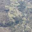
On-line Digital Images |
DP 212199 |
RCAHMS Aerial Photography Digital |
Oblique aerial view of a township at Glenleraig, looking SE. |
14/5/2015 |
Item Level |
|
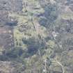 |
On-line Digital Images |
DP 212200 |
RCAHMS Aerial Photography Digital |
Oblique aerial view of a township at Glenleraig, looking SE. |
14/5/2015 |
Item Level |
|
 |
On-line Digital Images |
SC 2346139 |
Records of the Ordnance Survey, Southampton, Hampshire, England |
Glenleraig, NC13SE 4, Ordnance Survey index card, Recto |
c. 1958 |
Item Level |
|
 |
On-line Digital Images |
SC 2346140 |
Records of the Ordnance Survey, Southampton, Hampshire, England |
Glenleraig, NC13SE 4, Ordnance Survey index card, page number 1, Recto |
c. 1958 |
Item Level |
|
 |
On-line Digital Images |
SC 2346141 |
Records of the Ordnance Survey, Southampton, Hampshire, England |
Glenleraig, NC13SE 4, Ordnance Survey index card, page number 2, Verso |
c. 1958 |
Item Level |
|
|
All Other |
551 166/1/1 |
Records of the Ordnance Survey, Southampton, Hampshire, England |
Archaeological site card index ('495' cards) |
1947 |
Sub-Group Level |
|


