
Glenleraig


Township (Post Medieval)
Site Name Glenleraig
Classification Township (Post Medieval)
Alternative Name(s) Gleann Learaig
Canmore ID 4554
Site Number NC13SE 4
NGR NC 1528 3140
NGR Description Centred NC 1528 3140
Datum OSGB36 - NGR
Permalink http://canmore.org.uk/site/4554


- Council Highland
- Parish Assynt
- Former Region Highland
- Former District Sutherland
- Former County Sutherland
NC13SE 4 153 314.
Glen Lerag: Shown as a group of four buildings surrounded by arable depopulated by 1878 (J Home 1747).
W Roy 1747; OS 6"map, Sutherland, 2nd ed., (1878); J Home 1774-5.
About 20 buildings shown.
J Home 1774-5.
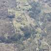
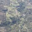
The area centred at NC 153 314 contains the remains of approximately twenty rectangular buildings, and several sheep folds and small enclosures. There are also indications that the area has been cultivated. The remains now consist of low dry stone walls, the western buildings have rounded corners and appear to be earlier. The name Glenlaraig now applies to a farmstead and cottage at the head of Loch Nedd, there is no evidence of an earlier settlement at this spot. Visited by OS (G H) 18 May 1962.
The deserted township of Gleann Leireag (current spelling) is as described by the previous field investigator. The building footings range in size from 4.0m by 4.0m to 17.0m by 4.0m and average 0.5m high.
Visited by OS (J B) 14 August 1980.
A township comprising one unroofed building and three enclosures is depicted on the 1st edition of the OS 6-inch map (Sutherland 1878, sheet lix). Twenty-one unroofed buildings and five enclosures are shown on the current edition of the OS 1:10,560 map (1967).
Information from RCAHMS (SAH) 6 September 1995.
Field Visit (1 December 2009)
A very large township with over 50 structures remaining, including buildings and enclosures/pens. All appear to be constructed from gathered rubble.
153A - Bank running up from river to the North. Earth and stone, moss covered. 100m N then 45m W, curvilinear, 0.7m wide and up to 2.2m high and steeper on the outside face.
153b - 12m x 3m, NW-SE alignment, wall thickness of 0.5m and up to 0.9m high. Consists of two compartments, 7.5m to division from the SE. Entrance is to the NE, a bowed end to the NW. The division wall has an entrance to the east, the door is 2m after division.
153c - 8.8m x 5m x 0.6m. NW-SE. Possible entrance on the SW side. Bowed end to the NW. Extra footings to the SE, unclear as to whether it was a lean-to shack or the remains of the building being shortened at some point. Wall leads from S corner and curving around the ridge. Walls up to 1m spread.
153d -3 clearance cairns all 2m diameter x 0.4m high situated in a 15m area.
153e - Enclosure 0.4m high made of stone and earth and covered with bracken and grass. 0.8m wide bank.
153f - Enclosure with 0.5m high stone wall, 1m wide.
153g - Semi-circular enclosure like a sheepfank. 8m diameter, 0.5m high and constructed of stone.
153h - Building 7m x 3.5m, stone walls. V spread to 0.7m wide, aligned NW-SE. Entrance to the south. Much rubble infill.
153i - 6m x 4m stone boulder footings, aligned NNE-SSW. Possible east entrance. Made of a single line of boulders.
153j - 4m x 3m stone building footings aligned NW-SE and very grassed over.
153k - 10m x 5m, aligned NW-SE building with an entrance to the SW. Built on bedrock with walls up to 0.5m high and 0.7m wide.
153l - 17m x 5m x 0.75m stone building aligned NNE-SSW. Divided into two compartments of 7m and 10m. 8m x 4.5m outbuilding to NW side, with an entrance to the S. South end bowed with no obvious entrance.
153m - 12m x 5m x 0.9m stone building, aligned NNE-SSW. Open ended 1.5m cell in NE corner. Walls 0.6m wide. Situated on a slope.
153n - 3m x 2m x 1m stone wall aligned NW-SE. 0.6m wide.
153o - 10m x 3m x 0.4m, aligned NW-SE. Up to 1m wall spread. Stone.
153p - Enclosure truncated by road, 6m x 11m aligned NE-SW. 18m wall running W from enclosure to modern sheepfank.
153q - 9m x 4m x 0.75m, aligned E-W, stone building. Awful collapse to the N and S walls. Entrance to the N.
153r - 8m x 5m stone footings aligned E-W
153s - L-shaped building, stone walls up to 1.2m spread, bowed ends, 0.4m high.
153t - 4m x 3m, aligned E-W, rubble very spread.
153u - 12m x 6m x 0.3m, aligned NNW-SSE. Very spread walls.
153v - ruinous enclosure, 3m x 4m, aligned NW-SE, single boulder remains, no NE wall.
153w - 20m x 12m x 0.8m, aligned NNE-SSW, walls 0.6m spread, no north wall.
153x - 3 x 5m, aligned E-W, barely footings, very uneven and ruinous.
153y - 4m x 4m, aligned NW-SE, only NW and SE walls remain, very ruinous footings.
153z - 2 clearance cairns, 0.5m high, oval 2m x 1m, aligned NW-SE.
153aa - curvilinear wall, leading around and across a natural ridge, made of earth and stone. 0.4m high, and leads 70m uphill and 100m across a ridge, curving round to the road.
153ab - Uneven, almost circular enclosure, 8m in diameter, 0.5m high, walls very spread rubble.
153ac - 17m x 16m oval sheepfank situated on a slope, up to 0.5m high walls but uneven spread of 1m walls, made of Lewisian Gneiss.
153ad- Stone, 14m x 4m with bowed SE end, aligned NW-SE, walls 0.6m wide, 0.4m high. Rubble spread everywhere. Clearance cairn 2m x 1m by SE end.
153ae - Enclosure joining 3 buildings (153ad, 153af and 153ag). No S wall, 0.4m high and 0.6m wide walls.
153af - 10m x 4.5m stone building, walls 0.6m wide and 0.5m high, aligned N-S, entrance to the East.
153ag - 17m x 6m x 0.5m stone building, aligned NW-SE, includes boulders up to 1m x 1.2m.
153ah - L-shaped building, 13m x 9.5m, walls 0.4m spread.
153ai - 9m x 4m x 0.4m, aligned NW-SE, walls up to 1m spread, entrance either on N or S side
(HLP_no 153)
Assynt's Hidden Lives Project 2009
Excavation (26 September 2011 - 7 October 2011)
NC 1517 3149 As part of the Life and Death in Assynt’s Past Project an excavation of a single building within the Glenleraig Township was undertaken 26 September–7 October 2011. The building is one of around 50 structures within the township, which was cleared in 1812.
The excavation revealed that the building was a typical long house, with accommodation for both people and animals, although no internal division separating the two distinct areas was found. Partial floor remains and a central hearth were recorded in the ‘house’ end of the building. The hearth appeared to have been fed by flues which indicated that it may once have been a more complex structure. The byre end of the building was split into two areas on a longitudinal axis. One half of the area had been lowered and a slope formed by the deliberate reduction of the underlying bedrock, possibly to enhance drainage. A raised platform and stone kerb had then been built to create a level area. The only entrance to the building appeared to have been through the byre.
A small number of ceramic fragments and glass were recovered from inside the building, together with the remains of a boot and a single unidentified iron object. Initial examination of the pottery indicated that it is of good quality and predates 1780. The assemblage of predominantly cream wares includes a Staffordshire mug. The presence of good quality wares suggests that the inhabitants had a certain amount of disposable income.
Archive: RCAHMS (intended)
Funder: Heritage Lottery Fund and Highland Leader
AOC Archaeology Group, 2011

