
Scheduled Maintenance
Please be advised that this website will undergo scheduled maintenance on the following dates: •
Every Thursday from 17th October until 7th November from 11:00 to 15:00 •
Tuesday, 22nd October from 11:00 to 15:00
During these times, some services may be temporarily unavailable. We apologise for any inconvenience this may cause.
Coldoch Broch


Broch (Iron Age)(Possible)
Site Name Coldoch Broch
Classification Broch (Iron Age)(Possible)
Canmore ID 45356
Site Number NS69NE 6
NGR NS 69647 98131
Datum OSGB36 - NGR
Permalink http://canmore.org.uk/site/45356


- Council Stirling
- Parish Kincardine (Stirling)
- Former Region Central
- Former District Stirling
- Former County Perthshire
NS69NE 6 69639 98128
(NS 6964 9813) Coldoch Broch (NR)
OS 6" map (1958)
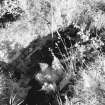
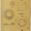
The remains of the broch are between 27ft 6ins and 29ft 6ins in diameter, within a wall of smallish poor-quality masonry 17ft 6ins to 19ft 6ins thick. The wall-core stands to a maximum height of 8ft and the inner wall-face is about 4ft high. There are three mural chambers and a stairway within the wall.
A Graham 1949
Generally as described and illustrated by Graham. (His plan seems to be slightly stylised).
Resurveyed at 1/2500.
Visited by OS (RD) 26 September 1968.
Field Visit (August 1978)
Coldoch NS 696 981 NS69NE 6
This broch measures 8.8m in maximum diameter within a wall which varies between 5.2m and 5.8m in thickness and stands up to 2.4m in height. The entrance is on the E and three chambers and a stairway are visible within the thickness of the wall.
RCAHMS 1979, visited August 1978
Graham 1949, 12-14
Publication Account (2007)
NS69 1 COLDOCH
NS/6963 9812 (GPS – NS/69652 98129)
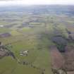
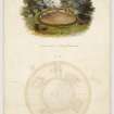
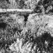
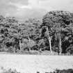
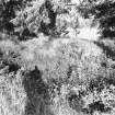
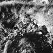
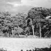
This probable solid-based broch or broch-like dun in Kincardine stands on a slight rise immediately next to the flat land of the Forth Valley – originally an extensive marsh. The broch was cleared out just before 1870 and a plan prepared [2]; apparently a report on the excavation was expected but never materialized: “A notice of this broch, with plans, will be in the Society’s Transactions, the Archaeologia Scotica, vol. V.” [2, 38, footnote). There is nothing in the journal mentioned. The entrance passage, the inner wallface and the various intra-mural features are still exposed but the site is difficult to assess now, being usually overgrown with turf and weeds. The author has some photographs of internal features but they show very little and are not included here.
Graham [4] was the first to describe the site again in modern times, giving the diameter of the central court as from 8.39 - 9.00m (27 ft 6 ins to 29 ft 6 ins), within a wall from 5.34 - 5.95m (17 ft 6 ins to 19 ft 6 ins) thick. The wall is of poor-quality masonry of smallish stones and the core stands to a maximum height of 2.44m (8 ft); the inner wallface is about 1.22m (4 ft) high. There are three mural chambers and a stairway within the wall, while the entrance is on the east side. The poor quality of the masonry is the reason for doubting that this structure could ever have been a broch tower, though in every other way the ground plan is typical.
The unusually narrow entrance passage is about 5.80m (19 ft) long and faces just north of east; it is 0.71m (2 ft 4 in) wide at its outer end and only 59cm (1 ft 11 in) at the inner. The door-frame is about 2.14m (7 ft) from the exterior and the two checks – one of which is broken – are apparently of upright stone slabs. The bar-hole is on the right (north) of the passage and was apparently 2.14m (7 ft) deep at the time of the excavation [4, 13]. The bar-socket – now obscured because of displacement of the stonework – was apparently 61cm (2 ft) then. The passage widens to 1.22m (4 ft) behind the door-frame. There is no guard cell.
The other intra-mural features consist of the doorway to the intra-mural stair at 7 o’clock and doors to cells at 10, 1 and 3 o’clock. There were also two small recesses or aumbries about 20cm (8 in) square in the inner wallface between 7 and 8 o’clock (see Torwood – NS88 1).
The doorway to the stair is 69cm (2 ft 3 in) wide at its inner end and widens slightly towards the stair lobby; there is only a very slight recess instead of a stair-foot guard cell (see Buchlyvie – NS59 2). Now roofless the doorway appears to have still been lintelled in 1870 [4, 14, f.n. 1]. The stairway is 81cm (2 ft 8 in) wide and runs out on to the present wallhead; seven steps remained in 1870.
The three intra-mural cells are approximately rectangular in shape, the one at 10 o’clock having one curved and one straight end; the doorway to that at 4 o’clock is blocked. The doorway to the cell at 1 o’clock was still lintelled in 1949 [4, Pl. III.3]. The lengths of the three cells (starting at 10 o’clock) are – 2.62m (8 ft 7 in), 2.44m (8 ft 0 in) and 2.59m (8 ft 6 in). The rectangular shape of the cell at 4 o’clock is very marked but not far above the floor the corners become curved at the upper part is oval; in 1870 this cell had a complete roof with a ‘beehive’ corbelled structure.
Finds: fragments of whalebones are reported to have been found inside this broch (the author clearly remembers reading about this many years ago but has been unable to track down the source); such are known from the blue marine clay which indicates that the Forth valley was once a shallow estuary of the sea in much earlier times. Whales were doubtless occasionally stranded in the shallow water and the bones found when the estuary became a marsh in pre-Iron Age times. Coldoch broch is close to the old estuary.
Dimensions: diameter of central court 8.39 - 9.00m (29 ft 6in to 27 ft 6 in), wall thickness from 5.34 - 5.95m (17 ft 6 in and 19 ft 6 in): the wall proportion is approx. 56.5%.
Sources: 1. NMRS site no. NS 69 NE 6: 2. MacLaglan 1872, 37-9: 3. Anderson 1877, 324 and fig.: 4. Graham 1949, 12-14: 5. RCAHMS 1979b, no. 151: 6. McInnes 1985: 7. Armit 2003, 125.
E W MacKie 2007
Test Pit Survey (27 February 2014 - 1 March 2014)
NS 69639 98128 A programme of vegetation clearance, test pitting and laser scanning was undertaken at Coldoch Broch. The work which was undertaken, 27 February – 1 March 2014, formed part of the Lowland Brochs Project funded by Forestry Commission Scotland.
The vegetation clearance and test pitting was carried out by the Archaeology Scotland Adopt-a-Monument team, with support from Jonathan Wordsworth, staff from Stirling Council and volunteers, in an area outside of the scheduled area at the broch. A subsequent phase of work consisted of the laser scanning of the broch and the production of drawings by AOC Archaeology Group.
Archive and report: Archaeology Scotland and RCAHMS (intended)
Funder: Forestry Commission Scotland, Adopt-a-Monument (support in kind), Murray Cook and Fiona Isobel Watson
Fiona Isobel Watson, Phil Richardson, Jonathan Wordsworth
and Murray Cook
(Source: DES)

