
Cleddans


Fortlet (Roman)
Site Name Cleddans
Classification Fortlet (Roman)
Canmore ID 44555
Site Number NS57SW 50
NGR NS 5082 7225
Datum OSGB36 - NGR
Permalink http://canmore.org.uk/site/44555


- Council West Dunbartonshire
- Parish Old Kilpatrick (Clydebank)
- Former Region Strathclyde
- Former District Clydebank
- Former County Dunbartonshire
NS57SW 50 5082 7225.
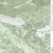
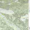
NS 508 723 Cleddans. A Roman fortlet located by trial trenching in 1979 measured internally 18m east-west by 17.6m north-south within a rampart set on a 3.6m wide stone base.
It predates the Antonine Wall which abuts it at the north-east corner at a sharp angle. The north-west corner had been much disturbed by ploughing but the Wall would have joined it some way south of this angle.
F O Grew 1980; L Keppie and J Walker 1980.
NS 5082 7225 There is no surface trace of the fortlet or the 1979 excavations on the highest level area of a field under plough/stubble at circa 70m OD.
Site surveyed at 1:1250 from excavation plans provided by L Keppie, Hunterian Museum.
Visited by OS (J R L) 13 January 1981.
Trial Trench (1979)
NS57SW 50 5082 7225.
NS 508 723 Cleddans. A Roman fortlet located by trial trenching in 1979 measured internally 18m east-west by 17.6m north-south within a rampart set on a 3.6m wide stone base.
It predates the Antonine Wall which abuts it at the north-east corner at a sharp angle. The north-west corner had been much disturbed by ploughing but the Wall would have joined it some way south of this angle.
F O Grew 1980; L Keppie and J Walker 1980.
Field Visit (13 January 1981)
NS 5082 7225 There is no surface trace of the fortlet or the 1979 excavations on the highest level area of a field under plough/stubble at circa 70m OD.
Site surveyed at 1:1250 from excavation plans provided by L Keppie, Hunterian Museum.
Visited by OS (J R L) 13 January 1981.
Publication Account (2008)
A 1:25000 scale map of the Antonine Wall was published by RCAHMS in 2008. The map shows the course of the Antonine Wall on a modern map base, including areas where the Wall is in public ownership or care and can be visited. The data had been collated as part of the project to prepare maps for the World Heritage Site nomination bid.

