|
Manuscripts |
MS 2705 |
|
Report - Trial trenching established outlines of Roman fortlet along Antonine Wall at Cleddans, 1980. |
1980 |
Item Level |
|
 |
On-line Digital Images |
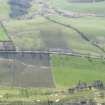
DP 249626 |
Historic Environment Scotland |
Oblique aerial view. |
24/3/2017 |
Item Level |
|
|
Digital Files (Non-image) |
GV 007524 |
Records of Historic Scotland, Edinburgh, Scotland |
Map 8 of 8 from IV.I 1-8 - Series 1: Maps of the Antonine Wall at a scale of 1:25000 showing the proposed World Heritage Site, known forts and fortlets, camps, other features and the buffer zones. Maps were prepared for the nomination document to propose the extension of the Frontiers of the Roman Empire World Heritage Site through the addition of the Antonine Wall. |
2006 |
Item Level |
|
 |
On-line Digital Images |
SC 1926675 |
Records of Historic Scotland, Edinburgh, Scotland |
Map 8 of 8 from IV.I 1-8 - Series 1: Maps of the Antonine Wall at a scale of 1:25000 showing the proposed World Heritage Site, known forts and fortlets, camps, other features and the buffer zones. Maps were prepared for the nomination document to propose the extension of the Frontiers of the Roman Empire World Heritage Site through the addition of the Antonine Wall. |
2006 |
Item Level |
|
|
Digital Files (Non-image) |
GV 007531 |
Records of Historic Scotland, Edinburgh, Scotland |
Map 8 of 8 from IV.2 1-8 - Series 2: Maps of the Antonine Wall at a scale of 1:25000 showing the proposed World Heritage Site, known forts and fortlets, camps, other features and the buffer zones. Maps were prepared for the nomination document to propose the extension of the Frontiers of the Roman Empire World Heritage Site through the addition of the Antonine Wall. |
2006 |
Item Level |
|
 |
On-line Digital Images |
SC 1927925 |
Records of Historic Scotland, Edinburgh, Scotland |
Map 8 of 8 from IV.2 1-8 - Series 2: Maps of the Antonine Wall at a scale of 1:25000 showing the proposed World Heritage Site, known forts and fortlets, camps, other features and the buffer zones. Maps were prepared for the nomination document to propose the extension of the Frontiers of the Roman Empire World Heritage Site through the addition of the Antonine Wall. |
2006 |
Item Level |
|
|
Digital Files (Non-image) |
GV 007569 |
Records of Historic Scotland, Edinburgh, Scotland |
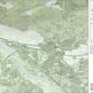
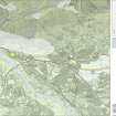
Map 36 of 39 from Series V. Maps of the Antonine Wall and its known features at a scale of 1:5000 showing the scheduled areas and the proposed World Heritage Site. Maps were prepared for the nomination document to propose the extension of the Frontiers of the Roman Empire World Heritage Site through the addition of the Antonine Wall. |
2006 |
Item Level |
|
 |
On-line Digital Images |
SC 1929444 |
Records of Historic Scotland, Edinburgh, Scotland |
Map 36 of 39 from Series V. Maps of the Antonine Wall and its known features at a scale of 1:5000 showing the scheduled areas and the proposed World Heritage Site. Maps were prepared for the nomination document to propose the extension of the Frontiers of the Roman Empire World Heritage Site through the addition of the Antonine Wall. |
2006 |
Item Level |
|
|
Digital Files (Non-image) |
GV 007597 |
Records of Historic Scotland, Edinburgh, Scotland |
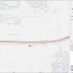
Antonine Wall 1:25000 broadsheet map - created in three sections - this is the western section of the map |
2008 |
Item Level |
|
 |
On-line Digital Images |
SC 1970706 |
Records of Historic Scotland, Edinburgh, Scotland |
Antonine Wall 1:25000 broadsheet map |
2008 |
Item Level |
|
|
Digital Files (Non-image) |
TM 000310 |
Records of Historic Scotland, Edinburgh, Scotland |
Zip file including: a Dxf file containing the polygons created to show the components of the Antonine Wall, along with the associated forts, expansions and military way. Shapefiles containing the same data and an associated layer file. |
2007 |
Item Level |
|
|
Digital Files (Non-image) |
GV 008531 |
Records of Historic Scotland, Edinburgh, Scotland |
Map showing the Antonine Wall, the World Heritage Site area, the areas of the World Heritage Site in public ownership or care, the Buffer Zone and the Council boundaries. Created for the World Heritage Site nomination - Management plan. |
2006 |
Item Level |
|
 |
On-line Digital Images |
SC 2170806 |
Records of Historic Scotland, Edinburgh, Scotland |
Map showing the Antonine Wall, the World Heritage Site area, the areas of the World Heritage Site in public ownership or care, the Buffer Zone and the Council boundaries. Created for the World Heritage Site nomination - Management plan. |
2006 |
Item Level |
|
 |
On-line Digital Images |
SC 2428074 |
Records of the Ordnance Survey, Southampton, Hampshire, England |
Cleddans, NS57SW 50, Ordnance Survey index card, page number 1, Recto |
1958 |
Item Level |
|
 |
On-line Digital Images |
SC 2428075 |
Records of the Ordnance Survey, Southampton, Hampshire, England |
Cleddans, NS57SW 50, Ordnance Survey index card, Recto |
1958 |
Item Level |
|
|
All Other |
551 166/1/1 |
Records of the Ordnance Survey, Southampton, Hampshire, England |
Archaeological site card index ('495' cards) |
1947 |
Sub-Group Level |
|


