Accessibility

Font Size

100% 150% 200%

Background Colour

Default Contrast
Close Reset

Sorn Old Bridge

Road Bridge (Period Unassigned)

Site Name Sorn Old Bridge

Classification Road Bridge (Period Unassigned)

Alternative Name(s) River Ayr

Canmore ID 43574

Site Number NS52NW 8

NGR NS 54966 26731

Datum OSGB36 - NGR

Permalink http://canmore.org.uk/site/43574

Ordnance Survey licence number AC0000807262. All rights reserved.
Canmore Disclaimer. © Bluesky International Limited 2025. Public Sector Viewing Terms

Toggle Aerial | View on large map

Digital Images

Sorn Old Bridge
General View
Sorn Old Bridge
General ViewGeneral viewView from East.Sorn Old Bridge, NS52NW 8, Ordnance Survey index card, RectoSorn Old Bridge, NS52NW 8, Ordnance Survey index card, page number 1, RectoSorn Old Bridge, NS52NW 8, Ordnance Survey index card, RectoView from North-East.Sorn, Dalgain Mill
View from SE showing part of SSE and ENE fronts of mill with cottage on right and part of bridge on leftSorn Old Bridge. View from East.

Administrative Areas

  • Council East Ayrshire
  • Parish Sorn
  • Former Region Strathclyde
  • Former District Cumnock And Doon Valley
  • Former County Ayrshire

Archaeology Notes

NS52NW 8 54966 26731

(NS 5496 2672) Sorn Old Bridge (NAT)

OS 6" map (1967)

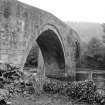
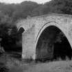
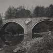
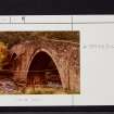
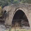
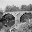
Built in the early 18th century, this is a two-span bridge, with dress stone arch rings and rubble wing walls. The arches are nearly semicircular, and there are triangular cutwaters.

J R Hume 1976

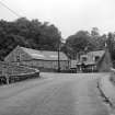
As described and still in use.

Visited by OS (JRL) 14 October 1981.

References

MyCanmore Image Contributions


Contribute an Image

MyCanmore Text Contributions