
Craigmarloch Wood


Animal Trap (Modern), Fort (Prehistoric), Palisade(S) (Prehistoric)
Site Name Craigmarloch Wood
Classification Animal Trap (Modern), Fort (Prehistoric), Palisade(S) (Prehistoric)
Canmore ID 42453
Site Number NS37SW 8
NGR NS 3443 7185
Datum OSGB36 - NGR
Permalink http://canmore.org.uk/site/42453


- Council Inverclyde
- Parish Kilmacolm
- Former Region Strathclyde
- Former District Inverclyde
- Former County Renfrewshire
NS37SW 8 3443 7185.
(NS 3445 7185) Fort (NR)
OS 6" map (1970)
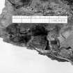
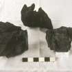
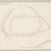
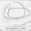
This fort stands at 450ft OD, within Craigmarloch Wood. It is flattened oval on plan, measuring 160ft by 85ft within the ruins of a wall, originally timber-laced and about 10ft thick. Small masses of vitrified matter were noted near the entrance, 5ft wide, in the WNW, by Miss Nisbet who carried out excavations in 1963-5. Test trenches in the interior failed to provide any clear evidence of structures; no occupation traces at all were found near the centre of the fort, where there is a modern fox conduit. An annexe, measuring 130ft by 60ft, on the NE is enclosed by a wall, showing features similar to the main fort wall, with a suggestion of post-sockets but no vitrification. A second annexe (H C Nisbet 1965) on the SW was shown to be a massive structure with a terraced build, related to the fairly steep slope. No occupation debris was found in either annexe, nor any conclusion evidence as to their date relative to the fort. The excavations showed that the fort wall, in the NW, overlay a double palisaded enclosure measuring about 210ft by 115ft (A Ritchie 1971). Virtually all the artifacts found were associated with this earlier occupation of the site. They included coarse pottery, shale rings, a tanged flint arrowhead, stone whorls, discs and hammers, a flint scarper and a fragment of a wooden vessel. The finds were placed in Paisley Museum. A radio-carbon date of 590 +/- 40 BC was obtained from material associated with the palisaded enclosure, while charcoal from the vitrified wall, though from a position such that it might possibly belong to a later period than the building of the wall, gave a date of 35-40 BC.
H C Nisbet 1963; 1964; 1966; R W Feachem 1977; E W MacKie 1969
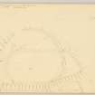
When visited in 1964, this was described as a sub-rectangular fort, in a poor state of preservation. It measured about 52.0m E-W by 30.0m transversely, enclosed by a turf-covered rubble rampart, 5.5m broad in the E, with a maximum height of 1.3m, though in places it fades out in the vegetation. A gap in the E side opened on to a level area formed by natural slopes. A fragment of fused wall face, about 1.0m long, was seen S of the entrance, in the WNW. Vague traces of a second rampart were seen along part of the N side at a lower level.
Surveyed at 1:2500.
Visited by OS (WDJ) 13 May 1964
Field Visit (5 May 1954)
Fort, Craigmarloch Wood.
This fort is situated on an eminence which stands in the gap between Knockmountain on the E and Devol Moor on the W and commands the route southwards from Port Glasgow. It is distant one mile and a half S of the S shore of the mouth of the River Clyde where this meets the Firth of Clyde, and a quarter of a mile WSW of the house marked on the Ordnance Survey maps as East Kilbride but to which the name Craigmarloch has been transferred from the abandoned house 330 yards to the SW. The knoll upon which the fort stands is one of a group of four each of which attains an elevation of a little over 500 feet O. D. No natural obstacles bar approach to the summit area from the E., but broad shallow gullies adjoin it to NNE and SSE and the steep rocky flanks of the knoll hinder access from the SW, W and NW.
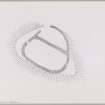
The fort [DP 149901] is subrectangular on plan with rounded corners, and measures 160 feet in length by 85 feet in breadth within the substantial ruin of a stone wall. This now consists of a mound of large stones and boulders which stands to a maximum height of about 3 feet 6 inches and is spread to a width of about 12 feet. No facing stones can be seen in situ, but it is estimated that the wall was originally out 8 feet or 10 feet in thickness. An entrance 6 feet wide pierces the arc and a ragged breach of uncertain character, 15 feet in extent, interrupts the ESE arc.
A stretch of the N section of the wall 130 feet in length forms the chord of a D-shaped annexe 60 feet in breadth. The arc consists of a ruined wall, similar in appearance to the wall of the fort but only about 6 feet in thickness, which lies on the SSW slope of the gully NNE of the site. A gap 50 feet in length in the arc of this may have included an original entrance to the annexe but there is no indication that direct communication with the fort was ever provided. The floor of the annexe rises 16 feet from NNE to SSW.
A stretch of ruinous wall 125 feet in length and about 6 feet thick runs from ESE to 70 feet beyond and 30 feet below the S section of the wall of the fort. Its E end rests on an outcrop which marks the W termination of the gully SSE of the fort while its end fades away on the steepening SW flank of the knoll. In addition, faint traces of what may have been walling, formed by a few boulders which appear to be in situ, occur at short distances beyond either end of the stretch of wall. They suggest that another annexe might have adjoined the fort to the S, but this is uncertain. Masses of vitrified matter appear in the stretch of the wall of the fort in the vicinity of the entrance. No other patches were observed elsewhere on the perimeter, and it is possible that these represent the result of the burning of a wooden gateway.
The interior of the fort is planted with trees and the only feature is a modern stone-built sunken fox-trap which lies in the S quarter.
Visited by RCAHMS (RWF) 5 May 1954
Reference (1957)
This site is noted in the ‘List of monuments discovered during the survey of marginal land (1951-5)’ (RCAHMS 1957, xiv-xviii).
Information from RCAHMS (GFG), 24 October 2012.
Note (4 August 2014 - 16 November 2016)
This fort occupies one of several hillocks in Craigmarloch Wood, with steep rocky slopes protecting its western flank and shallow gullies isolating it on the NNE and SSW. Subrectangular on plan, the interior measures about 49m from ESE to WNW by 26m transversely (0.11ha) within a wall reduced to a mound of rubble 3.5m in thickness by 1m in height. Extensive vitrifaction can be seen to either side of a narrow entrance on the WNW, and a broader gap on the ESE may indicate the position of a second, though this may equally be a more recent break. On the NNW side of the fort there is also what appears to be an annexe. This is shown on a plan drawn up by RCAHMS in 1954 as a D-shaped enclosure dropping down the slope to the N and measuring about 40m from ESE to WNW along the chord formed by the fort wall by 18m transversely within a wall reduced to a mound of rubble some 2m in thickness, but a later rendering of the remains by Helen Nisbet, prepared in the course of her excavations 1963-5, shows it pursuing a different line on the NW, swinging round the WNW end of the fort, with a clear implication that it forms the plinth she observed beneath the wall of the fort on the S (Nisbet 1996, 44, fig 2). If this is indeed the case, it represents the remains of an earlier enclosure of some 0.25ha, with an entrance on the NE. Another length of wall on the S side of the shallow gully flanking the southern side of the hillock is not so easily explicable as the line of an earlier perimeter and may indicate the presence of an annexe, albeit that the greater part of its interior lies on the boggy floor of the gully. The excavations concentrated on the WNW end of the fort, revealing that the fort wall, which measured about 3m in thickness over its faces, was a complex structure, with an inner kerbed core and possible evidence of both upright and longitudinal timberwork, as well as the casts of transverse beams in the vitrified masses to either side of the entrance; the entrance itself was 1.8m wide, but the facing of its sides included lumps of vitrifaction and it appears to have been reconstructed after the destruction of the timber-laced wall on a narrower design. In the third season twin palisade trenches were uncovered outside the entrance, adding a further dimension to what is evidently a complex history of occupation and construction. The palisades were thought to have been burnt and replaced on at least one occasion and are probably associated with occupation deposits predating the fort which produced a rich assemblage of coarse pottery, five fragments of iron, fragments of crucible, a mould for a decorative boss, fragments of shale bracelets and working debris, a tanged flint arrowhead and a disc of barytes.
Information from An Atlas of Hillforts of Great Britain and Ireland – 16 November 2016. Atlas of Hillforts SC1341

