Field Visit


Date 5 May 1954
Event ID 925521
Category Recording
Type Field Visit
Permalink http://canmore.org.uk/event/925521
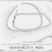
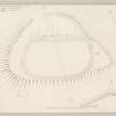
Fort, Craigmarloch Wood.
This fort is situated on an eminence which stands in the gap between Knockmountain on the E and Devol Moor on the W and commands the route southwards from Port Glasgow. It is distant one mile and a half S of the S shore of the mouth of the River Clyde where this meets the Firth of Clyde, and a quarter of a mile WSW of the house marked on the Ordnance Survey maps as East Kilbride but to which the name Craigmarloch has been transferred from the abandoned house 330 yards to the SW. The knoll upon which the fort stands is one of a group of four each of which attains an elevation of a little over 500 feet O. D. No natural obstacles bar approach to the summit area from the E., but broad shallow gullies adjoin it to NNE and SSE and the steep rocky flanks of the knoll hinder access from the SW, W and NW.
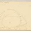
The fort [DP 149901] is subrectangular on plan with rounded corners, and measures 160 feet in length by 85 feet in breadth within the substantial ruin of a stone wall. This now consists of a mound of large stones and boulders which stands to a maximum height of about 3 feet 6 inches and is spread to a width of about 12 feet. No facing stones can be seen in situ, but it is estimated that the wall was originally out 8 feet or 10 feet in thickness. An entrance 6 feet wide pierces the arc and a ragged breach of uncertain character, 15 feet in extent, interrupts the ESE arc.
A stretch of the N section of the wall 130 feet in length forms the chord of a D-shaped annexe 60 feet in breadth. The arc consists of a ruined wall, similar in appearance to the wall of the fort but only about 6 feet in thickness, which lies on the SSW slope of the gully NNE of the site. A gap 50 feet in length in the arc of this may have included an original entrance to the annexe but there is no indication that direct communication with the fort was ever provided. The floor of the annexe rises 16 feet from NNE to SSW.
A stretch of ruinous wall 125 feet in length and about 6 feet thick runs from ESE to 70 feet beyond and 30 feet below the S section of the wall of the fort. Its E end rests on an outcrop which marks the W termination of the gully SSE of the fort while its end fades away on the steepening SW flank of the knoll. In addition, faint traces of what may have been walling, formed by a few boulders which appear to be in situ, occur at short distances beyond either end of the stretch of wall. They suggest that another annexe might have adjoined the fort to the S, but this is uncertain. Masses of vitrified matter appear in the stretch of the wall of the fort in the vicinity of the entrance. No other patches were observed elsewhere on the perimeter, and it is possible that these represent the result of the burning of a wooden gateway.
The interior of the fort is planted with trees and the only feature is a modern stone-built sunken fox-trap which lies in the S quarter.
Visited by RCAHMS (RWF) 5 May 1954