
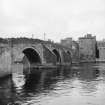
Ayr, Auld Brig


Footbridge (Period Unassigned), Road Bridge (Period Unassigned), Sundial (Period Unassigned)
Site Name Ayr, Auld Brig
Classification Footbridge (Period Unassigned), Road Bridge (Period Unassigned), Sundial (Period Unassigned)
Alternative Name(s) Auld Brig O' Ayr; Old Bridge Of Ayr; Auld Bridge; River Ayr
Canmore ID 41829
Site Number NS32SW 6
NGR NS 33859 22113
Datum OSGB36 - NGR
Permalink http://canmore.org.uk/site/41829


- Council South Ayrshire
- Parish Ayr
- Former Region Strathclyde
- Former District Kyle And Carrick
- Former County Ayrshire
NS32SW 6 33859 22113
(NS 3385 2210) Auld Brig [NR]
OS 1:10, 000 map (1978).
For adjacent (on NE) Brig Port (NS 3389 3389 2213), see NS32SW 34.
For successor New Bridge (downstream, to NW), see NS32SW 153.
EXTERNAL REFERENCE
National Library of Scotland. 1 Engraving of the Twa Brigs.
Earnock MSS, I, 90.
(Undated) information in NMRS.
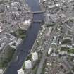
(Location cited as NS 339 221). Old Bridge of Ayr, built 1470-1525, extensively repaired 1910. A 4-span rubble bridge, with 3 segmental arches and a pointed arch, built of dressed stone throughout. There are massive triangular cutwaters. Now a footbridge.
J R Hume 1976.
Though the first reference indicating that there was or might have been a bridge over the River Ayr is in a charter of Alexander II (1214-49), The Auld Brig probably dates from the 15th century (Gourlay and Turner). Hume states that it was built 1470-1525. However, it has been rebuilt and repaired many times since then, notably in 1588 and 1907-10.
It is a 4-span rubble bridge, with three segmental arches and a pointed arch, built of dressed stone throughout; it has massive triangular cutwaters. Now only in use as a footbridge.
R W Brash and A Leach 1972; J R Hume 1976; R Gourlay and A Turner 1977.
The Auld Brig is as described; it is 5.0m wide between the parapets. A plaque states: "Auld Brig of Ayr, erected in the 13th century..." The date "1232" is cut in an adjacent stone. This is obviously a modern insertion. The style of the bridge would not indicate a pre-15th century date of construction (probably on the site of an earlier bridge).
Visited by OS (JLD) 27 December 1955
No change to the previous information.
Visited by OS (MJF) 28 October 1980.
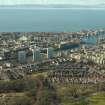
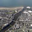
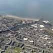
This bridge carries a footpath across the River Ayr to the S of the centre of Ayr (NS32SW 108).
The location assigned to this record defines the approximate midpoint of the structure. The available map evidence indicates that it extends from NS c. 33884 22139 to NS c. 33827 22081.
Information from RCAHMS (RJCM), 19 May 2006.
Construction (1491)
Ayr's Royal Charter of 1236 mentions a bridge, but a paymwent noted in 1491 clearly mentions masons on the bridge, so assumed to be the building date of the present structure.
R Paxton and J Shipway 2007
Project (2007)
This project was undertaken to input site information listed in 'Civil engineering heritage: Scotland - Lowlands and Borders' by R Paxton and J Shipway, 2007.
Publication Account (2007)
The origins of the Auld Brig are uncertain, although mention of a bridge is made in Ayr’s Royal Charter of 1236. Inglis mentions that a payment made by James IV to masons in 1491 is generally assumed to relate to its construction. The bridge has four arches of 52–53 ft each and the piers are 15 ft wide. The width within the parapets is 12 ft.
In 1597 the brig was described as ruinous. Little is known of its later history but in 1732 the north arch fell. The brig was rebuilt and repaired from time to time and from 1907–10, largely on the initiative of J. A. Morris, FRIBA of Ayr, against the advice of Sir William Arrol. Urgent and drastic remedial works were carried out to refurbish it under the direction of W. S. Wilson.
Shafts were sunk within the piers to the foundations and the bases grouted and concreted solid. Stonework was replaced and the superstructure strengthened internally, involving underpinning, by concrete in walls and slabs, and the whole structure was repointed and made good, retaining as much of the original work as practicable.
The engineering work was carried out by direct labour under the supervision of Simpson & Wilson, consulting engineers, and Morris, who attended to the archaeological features of the work. The bridge is now pedestrianised and a tourist attraction.
R Paxton and J Shipway 2007
Reproduced from 'Civil Engineering heritage: Scotland - Lowlands and Borders' with kind permission from Thomas Telford Publishers.

