
Following the launch of trove.scot in February 2025 we are now planning the retiral of some of our webservices. Canmore will be switched off on 24th June 2025. Information about the closure can be found on the HES website: Retiral of HES web services | Historic Environment Scotland
Ayr, Bruce Crescent, St John The Baptist's Church


Church (14th Century), Grave Slab(S) (Medieval), Long Cist(S) (Early Medieval), Coin(S) (Period Unassigned)
Site Name Ayr, Bruce Crescent, St John The Baptist's Church
Classification Church (14th Century), Grave Slab(S) (Medieval), Long Cist(S) (Early Medieval), Coin(S) (Period Unassigned)
Alternative Name(s) St John The Baptist Tower; Fort Castle; Ayr Fort
Canmore ID 41745
Site Number NS32SW 11
NGR NS 33369 22021
Datum OSGB36 - NGR
Permalink http://canmore.org.uk/site/41745


First 100 images shown. See the Collections panel (below) for a link to all digital images.
- Council South Ayrshire
- Parish Ayr
- Former Region Strathclyde
- Former District Kyle And Carrick
- Former County Ayrshire
NS32SW 11 33369 22021.
(NS 3337 2201) St John the Baptist's Church (NR) (remains of)
OS 1:1250 map (1960)
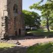
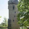
Ayr parish church, which was dedicated to St John the Baptist, was probably built about the time when Ayr was erected into a burgh (1203). However, the building is not specifically mentioned in documents until 1233. All that remains is the strong tower which was built against its West gable in the 15th century. This tower has been much reconstructed, notably in 1778 when the parapet was added, and was finally restored by the Marquis of Bute in 1914. Excavations in 1891 exposed the foundations of the church, showing that it was cruciform, measuring about 140ft in length by 80ft over the transepts.
Scott (1920) notes that these foundations can still be made out. At the same time, stones from the floor were taken to build an altar in the Episcopal Church.
Carrick (1913), who alleges that this church occupies the site of a Culdee church, states that skeletons were found under the foundations. Robert the Bruce held Parliament here in 1315. In 1652-4, Cromwell enclosed the church and graveyard within his fort, and the church was put to military use (a new church being built at NS 3390 2192 at that time - see NS32SW 7). It was re-used for worship in 1687-8 but around 1736 its stones were used in the steeple of the tolbooth in the Sandgate.
A I Dunlop 1953; R Gourlay and A Rurner 1977; W Dodd 1972; J Paterson 1847; J C Carrick 1913; A Mackenzie 1935; NSA 1845 (R Auld and A Cuthill)
Only the tower remains of this church, though the west gable of the main building is outlined on its wall. There is no evidence for a Culdee establishment here. A plaque on the garden (or churchyard) wall refers to the parliament meeting noted above.
Visited by OS (JLD) 28 December 1955
No change to the previous information.
Visited by OS (MJF) 30 October 1980
NMRS REFERENCE
Ref. Photo 1906
Originally the old Church of St John the Baptist, which stood on the Sands of Ayr from the 13th Century until Cromwell built his great Citadel in 1645 to command the Town and Harbour of Ayr - when the Church and its graveyard were enclosed by the Citadel.
The Church was put to military use and later demolished, but the Tower, which had been used as an Observation Post, was retained.
The Citadel walls were breached around 1857, and the area put up for sale in Edinburgh when it was bought by Mr John Miller who arrived before members of Ayr Town Council.
Known locally as "Baron Miller", he turned the Tower into a gentleman's Gothic Residence with additional towers, and a fine garden was laid out. He lived in the Fort Castle along with his two sisters, and a niece and her husband and family.
When the old man and his sisters died, his neice and her family sold the Tower to the Marquis of Bute who removed those parts added by Baron Miller and restored it to its original form as shown in the oldest known picture of the period.
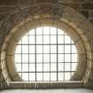
The Marquis spent a lot of money in "restoring" the Tower, and exposed a beautiful rose window on the West, before presenting the Tower to the Town of Ayr in 1914.
The last witch to be burned in Scotland is said to have been buried in the grounds around the Tower, and the two escape passages are believed to reach the shore from the Tower.
L A Murdoch,
1980
Photographed on behalf of the Buildings of Scotland publications.
RCAHMS 2009
Publication Account (1977)
The first notices of the parish church at Ayr post-date the charter of erection Record of a chapter meeting at Ayr in 1225 gives the indication that the assembly probably met in the parish church (Dunlop, 1953, 89), although the building is not mentioned specifically until 1233 when witnesses in a land dispute met in Ayr parish church (Pais. Reg, 1832, 166). Dedicated to St. John the Baptist, Ayr parish church was originally cruciform in plan with a tower added later. The tower is the only part of the original church to survive. The military nature of the structure has led many to assume that it was joined on to the church during a period of 'military stress' (Dunlop, 1953, 94). This is not necessarily the case. The tower dates from the fifteenth century, an age when the addition to ecclesiastical buildings of semi-castellated appendages was quite the rage. The western towers of St.
Machar's Cathedral, Old Aberdeen, provide an excellent parallel. While engaged in turning St. John's into an armoury, Cromwellian Troops overturned graves, a situation which led the burgh's officials to consider a new site for a churchyard and church. The Kirk Session decided either to build on ‘Sewaltounis ground or the Grayfriers' and in the end they chose the latter (Pagan, 1897, 55). Cromwell gave generously - 1000 merks - to the new church which was built on the 'room, place and stance of the Grey Friars Kirk' (Dunlop, 1953, 163, 103). Communion was first celebrated in the new Church building - now called the Auld Kirk of Ayr - in 1656 (Pagan, 1897, 57). It is still being used for worship today. In 1891 the foundation of the old parish church of St. John's was laid bare and stones were taken from here to construct an alter in the Episcopal Church (Carrick, 1913, 25).
Information from ‘Historic Ayr: The Archaeological Implications of Development’, (1977).
Excavation (October 1985)
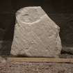
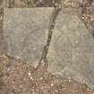
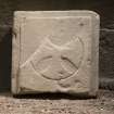
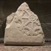
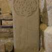
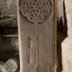
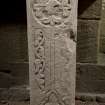
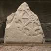
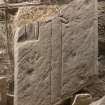
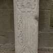
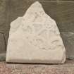
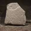
NS32SW 11 3337 2201. Work which began in October 1985 is still being continued at this site. Excavations to date have exposed the foundation of the N and S nave walls, a foundation line for the S side aisle and the S transept wall. The foundations for six nave piers and the moulded base on one have been uncovered. There is evidence of a timber floor pre-dating a stone one inside the nave and S aisle. Two early medieval stone coffins and numberous grave slabs with incised decoration have been recovered. A securely stratified coin sequence has been established dating from the 13th century to the present day.
H Smith 1986.
Archaeological Evaluation (12 March 2001 - 16 March 2001)
NS 3337 2201 An archaeological evaluation was undertaken at St John's Tower (NMRS NS 32 SW 11), in advance of proposed landscaping. Burials associated with the medieval church were found close to the surface in the area immediately around the tower. More burials were found to the N of the tower but at a much deeper level. Small finds associated with the burials indicate a date range of the 13th to 16th century.
Full report lodged with the NMRS.
Sponsor: South Ayrshire Council.
S Halliday 2001
Laser Scanning (April 2017)
HES (Survey and Recording) carried out a laser scan survey of the exterior of St John the Baptist's Church tower, Ayr and the ground within the site boundary wall. The work was carried out in preparation for a Community open day organised by Scotland's Urban Past. No scanning work was carried out inside the tower.
Measured Survey (5 April 2017 - 6 April 2017)
A measured survey of St John the Baptist's tower was undertaken by HES in April 2017 in advance of the 'Unlocking the Tower' open day, run by Scotland's Urban Past. A plane-table survey of of St John's tower and surrounds was undertaken to produce a 1:100 plan and GNSS data was collected to produce an illustration of St John's tower within boundary wall at a scale of 1:500.
Field Visit (25 May 2017)
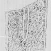
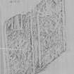
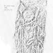
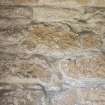
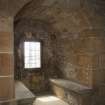
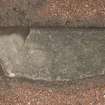
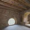
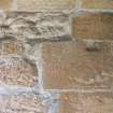
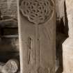
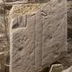
The remains of St John the Baptist’s church is a square plan, stone tower with graffiti carved and written on the exterior and interior walls. The tower comprises a ground floor and three upper floors. There is historical graffiti found on the walls of each floor of the tower and the following describes the general form, content and the locations of the graffiti. In terms of markings of historical evidence on the exterior walls, there are three locations of note.
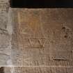
The graffiti on the exterior of the tower is on the east-facing wall; about 2m above present ground level, to the left hand side of the main door into the tower. It comprises rune-like, incised lines but appears to be a modern inscription, according to Professor Michael Barnes. The second location of carving is on the east-facing wall, situated 2m above the present ground level and comprises the carving of the letters A. D. The lettering appears to have been carved with a metal chisel and the letters are Roman font with clear serifs. The third area of interest on the exterior of the building comprises the evidence of musket shot holes, concentrated on the lower part of the north wall and with some evidence on the other three wall faces. It would appear that the tower was used for target practice whilst the citadel fort (NS32SW 15) was occupied by troops in the 1650s.
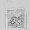
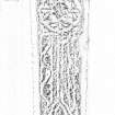
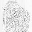
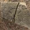
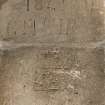
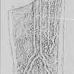
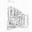
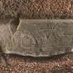
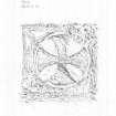
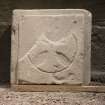
In the interior of the tower the three upper floors comprise a range of graffiti that is noteworthy for its form and content. The first floor mainly comprises incised, hand-carved graffiti. The second and third floors are notable for the pencil written graffiti and its content. The content of the carved material on the first floor ranges from initials to a possible apotropaic mark and two specific illustrations. One illustration on the east side of the west wall window seat resembles a profile of a castle or fort (see image DP255248), which may have been carved to represent the Cromwellian citadel fort. The other carved illustration comprises what appears to have been a crown (see image DP255249).
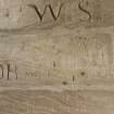
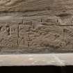
The graffiti on the second and third floors differs dramatically from that below. It comprises pencil-written names, addresses and accompanying dates. The majority is written on the mortar between the quarried stones of the walls. Analysis of the dates indicates that the dates range between 1902 and 2017, with the majority clustered between 1939 and 1970. The locations listed in the accompanying addresses range from Ayr, to other parts of Scotland, especially Glasgow and Govan and further afield to Kent, England. These names, dates and addresses appear to represent an unofficial ‘visitor’s book’, where people who accessed the tower chose to leave their details.
Visited by HES Survey and Recording (AGCH, ZB, JB) 25th May 2017.
Project
Recording Scotland's graffiti project was designed to review the range of historic and contemporary graffiti art across Scotland. It involved desk-based assessment and fieldwork at a number of example sites, to consider recording methodologies and dissemination practices.
Between 2016 and 2017, phase 1 of the project aimed to:
Aim 1: review a range of historic and contemporary graffiti art from across Scotland, already present in Canmore.
Aim2: undertake a research review of previous approaches to recording graffiti art in Canmore and other HERs, review and develop the current Thesaurus terms.
Aim 3: test and develop a range of recording methods within the following programmes or projects: Discovering the Clyde programme (1223), Scotland’s Urban Past (1222), Architecture and Industry projects, such as Urban Recording Projects (1028), Area Photographic Survey (311) and the Tomintoul and Glenlivet Landscape Partnership (1167).
Aim 4: the following test sites will be considered for research into the range of historic and contemporary graffiti. They will be analysed to demonstrate the different ages, contexts, styles and survivals of historic and contemporary graffiti: Polphail village (Canmore ID 299112), Scalan farmstead (170726), Cowcaddens Subway Station (243099), Croick Parish Church (12503), Dalbeattie Armament Depot (76279) and Dumbarton Rock (43376).
Aim 5: to research the potential for social media to play a role in crowd-sourcing information and archiving Scotland’s graffiti art.
In 2017-2019, phase 2 of the project aimed to:
Aim 1: To enhance the NRHE to the point at which it can be said to adequately represent the broad range of historic and modern graffiti that is evident throughout Scotland, and to explore ways by which that information can best be disseminated.
Aim 2: To develop guidelines that will convey the HES approach to researching and recording graffiti.
Aim 3: To write a specification for a book on Scotland’s graffiti.
Aim 4: To develop external partnerships to explore further ways to record graffiti and to identify and explore potential funding streams to enable further knowledge exchange and research.
The project was managed by Dr Alex Hale, with contributions from staff across Herirtage and Commercial and Tourism directorates.

