
Following the launch of trove.scot in February 2025 we are now planning the retiral of some of our webservices. Canmore will be switched off on 24th June 2025. Information about the closure can be found on the HES website: Retiral of HES web services | Historic Environment Scotland
Lewis, Callanish, 'tursachan'


Cairn (Neolithic) - (Bronze Age), Stone Circle (Neolithic) - (Bronze Age)
Site Name Lewis, Callanish, 'tursachan'
Classification Cairn (Neolithic) - (Bronze Age), Stone Circle (Neolithic) - (Bronze Age)
Alternative Name(s) Callanish Ii; Cnoc Ceann A' Gharraidh; Cnoc Ceann; Ceann A'gharaodh; Calanais
Canmore ID 4169
Site Number NB23SW 3
NGR NB 22215 32617
Datum OSGB36 - NGR
Permalink http://canmore.org.uk/site/4169


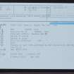
- Council Western Isles
- Parish Uig
- Former Region Western Isles Islands Area
- Former District Western Isles
- Former County Ross And Cromarty
NB23SW 3 22215 32617.
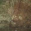
(NB 2220 3260) Stone Circle (NR) (remains of)
OS 6" map, (1965)
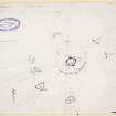
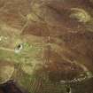
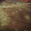
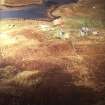
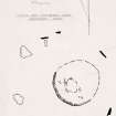
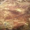
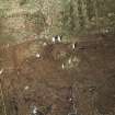
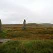
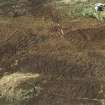
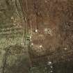
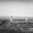
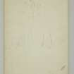
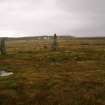
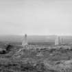
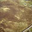
A circle of tall, thin standing stones surrounding a cairn, the original character of which cannot now be determined with certainty. The cairn measures 28' in diameter and 1' in height and shows in its centre an excavated cavity 6' in diameter. The stones, of which five are erect and two prostrate range from 10'9" to 6'6" in height. A slab 4'8" long by 1'9" in greatest breadth lies in front of the most westerly erect stone, pointing towards the centre of the circle, which is 65' in diameter.
RCAHMS 1928.
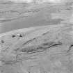
A stone circle with a cairn placed eccentrically within it, generally as described and planned by RCAHMS. The stones are on the same level as the surrounding ground, but the interior is slightly sunken.
Surveyed at 1/2500
Visited by OS (R L) 20 June 1969.
Scheduled as Ceann a'Gharaodh, stone circle and cairn.
Information from Historic Scotland, scheduling document dated 2 November 1992.
This cairn and stone circle are as described. The slightly sunken interior was water-filled on the date of visit.
Visited by RCAHMS (ARG, SPH) 29 August 2009
Field Visit (16 June 1914)
Stone Circle, "Tursachan", near Callanish.
On a plateau within 100 yards of one of the arms on the east side of Loch Roag, at an elevation of 50 feet above sea-level, ¼ mile west by south of the circle NB23SW 2 and 5/8 mile east-south-east of the Callanish megaliths (NB23SW 1), is a circle of five erect, tall thin stones set with their faces in the line of the circumference and two prostrate slabs with an excavated cairn near the centre of the enclosed area. The five erect stones, of which four are pointed, occupy the northern, eastern and southern arcs of the circle, and measur efrom 6 feet 6 inches to 10 feet 9 inches in height and from 3 feet to 5 feet 10 inches in width; the two prostrate stones, which have fallen inwards, are 8 feet 2 inches and at least 9 feet 11 inches long and 5 feet 8 inches and 7 feet 6 inches broad respectively, occupy the western arc. A slab 4 feet 8 inches long and 1 foot 9 inches at its greatest breadth lies in front of the western erect stone, 1 foot 2 inches from its base, pointing towards the centre of the circle. The diameter of the circle is 65 feet, and the remains of the central cairn, which measures 28 feet in diameter and 1 foot in height, show in its centre an excavated cavity 6 feet in diameter. (Figs. 66, 67.)
RCAHMS 1928, visited 16 June 1914.
OS map: Lewis xxv.
Field Visit (29 August 2009)
This cairn and stone circle are as described. The slightly sunken interior was water-filled on the date of visit.
Visited by RCAHMS (ARG,SPH) 29 August 2009

