
Ayr, Alloway, Brig O' Doon


Road Bridge (15th Century)
Site Name Ayr, Alloway, Brig O' Doon
Classification Road Bridge (15th Century)
Alternative Name(s) Old Bridge Of Doon; Tam O'shanter's Brig; River Doon
Canmore ID 41593
Site Number NS31NW 14
NGR NS 33237 17830
Datum OSGB36 - NGR
Permalink http://canmore.org.uk/site/41593


- Council South Ayrshire
- Parish Ayr
- Former Region Strathclyde
- Former District Kyle And Carrick
- Former County Ayrshire
NS31NW 14 33237 17830
(NS 3323 1782) Old Bridge of Doon (NR)
OS 1:10,000 map (1981)
Location formerly entered as NS 33241 17836.
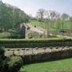
For (successor and present) New Bridge of Doon (downstream, to NW, at NS 33155 17943), see NS31NW 87.
EXTERNAL REFERENCE
Nat. Lib.
Country Life 19th July 1943 - Information and photograph
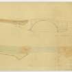
Non-Guardianship Sites Plan Collection, DC23116- DC23118, 1928.
(Undated) information in NMRS.
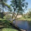
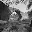
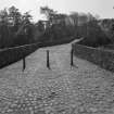
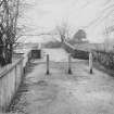
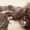
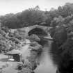
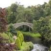
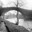
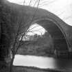
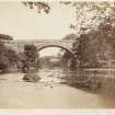
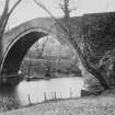
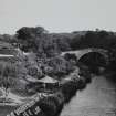
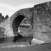
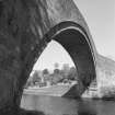
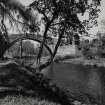
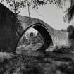
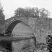
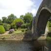
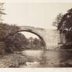
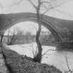
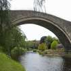
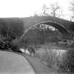
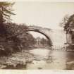
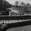
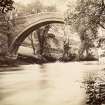
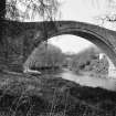
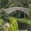
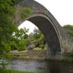
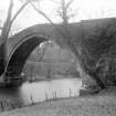
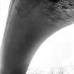
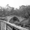
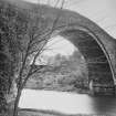
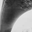
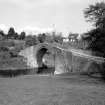
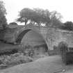
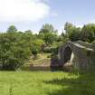
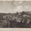
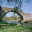
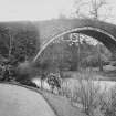
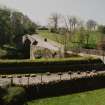
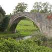
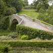
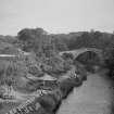
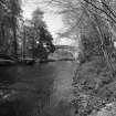
(Location cited as NS 332 178). Auld Brig o' Doon, Alloway, 15th century, repaired 1832. A slender segmental-arched bridge, with a dressed-stone arch ring and rubble spandrels and wing walls. Now a footbridge only. Made famous by Robert Burn's poem 'Tam o' Shanter'.
J R Hume 1976
Paterson states that the bridge is said to have been built by Bishop Kennedy, Chancellor of Scotland, who died in 1466. However, the first reference to the Bridge of Doon that Inglis could find in contemporary documents occurs in 1512; it is described as ruinous in 1593.
J Paterson 1852; H Inglis 1913
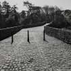
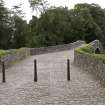
A high arched bridge showing traces of many repairs. The pathway over the bridge is paved with cobbles and is little used.
Visited by OS (JD) 12 December 1955
No change.
Visited by OS (JRL) 29 September 1980.
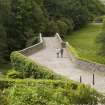
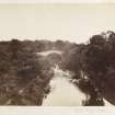
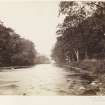
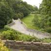
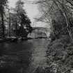
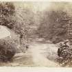
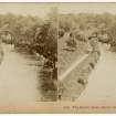
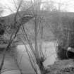
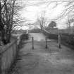
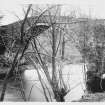
This bridge now carries a footpath over the River Doon to the S of Ayr. The river here forms the boundary between the parishes of Ayr (to the NE) and Maybole (to the SW).
The location assigned to this record defines the midpoint of the structure. The available map evidence suggests that it extends from NS c. 33228 17818 to NS c. 33242 17837.
Information from RCAHMS (RJCM), 23 May 2006.
Construction (1460)
Stylistically, a mid-fifteenth century bridge.
Modification (1978)
Refurbished.
Project (2007)
This project was undertaken to input site information listed in 'Civil engineering heritage: Scotland - Lowlands and Borders' by R Paxton and J Shipway, 2007.
Publication Account (2007)
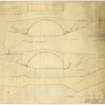
A masonry bridge dating from about 1460 with an arch of 72 ft span, large for a medieval bridge, and a rise of 26 ft.Large areas of the stonework have been replaced over the years and indifferently match the original in colour, dressing and courses. The bridge was refurbished in 1978. An unusual feature noticed by Inglis was the old parapet copestones shaped like a handrail. The bridge is now pedestrianised and a major tourist attraction.
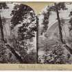
The line of the cobbled roadway is cranked in plan, due to an ancient belief that this irregular form deterred witches from crossing. This bridge also was immortalised by Alloway born Burns in his poem Tam O’ Shanter. Burns tells of Tam, riding home alone on Meg, his faithful mare, on a wild night after a merry evening with his friends in an Ayr hostelry, being pursued by fiends and witches from the haunted Auld Alloway Kirk and believing, as decreed by ancient superstition, that if he crossed flowing water they could not follow.
R Paxton and J Shipway 2007
Reproduced from 'Civil Engineering heritage: Scotland - Lowlands and Borders' with kind permission from Thomas Telford Publishers.

