 |
On-line Digital Images |
SC 2422427 |
Records of the Ordnance Survey, Southampton, Hampshire, England |
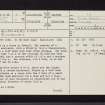
Burnhead Moor, NS27SE 18, Ordnance Survey index card, page number 1, Recto |
1958 |
Item Level |
|
 |
On-line Digital Images |
SC 2422428 |
Records of the Ordnance Survey, Southampton, Hampshire, England |
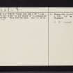
Burnhead Moor, NS27SE 18, Ordnance Survey index card, page number 2, Verso |
1958 |
Item Level |
|
|
All Other |
551 166/1/1 |
Records of the Ordnance Survey, Southampton, Hampshire, England |
Archaeological site card index ('495' cards) |
1947 |
Sub-Group Level |
|
|
All Other |
551 30/17/3 |
Records of CFA Archaeology Ltd, archaeologists, Musselburgh, East Lothian, Scotland |
Archive from cultural heritage assessment for Inverclyde Wind Farm. |
9/2012 |
Sub-Group Level |
|


