
Pricing Change
New pricing for orders of material from this site will come into place shortly. Charges for supply of digital images, digitisation on demand, prints and licensing will be altered.
Toward Castle


Tower House (Medieval)
Site Name Toward Castle
Classification Tower House (Medieval)
Alternative Name(s) Castle Toward
Canmore ID 40703
Site Number NS16NW 1
NGR NS 11860 67860
Datum OSGB36 - NGR
Permalink http://canmore.org.uk/site/40703


- Council Argyll And Bute
- Parish Dunoon And Kilmun
- Former Region Strathclyde
- Former District Argyll And Bute
- Former County Argyll
NS16NW 1 11860 67860
For successor country house of Castle Toward (NS 1146 6816) and associated buildings, see NS16NW 22.00.
(NS 1186 6785) Toward Castle (NR) (Remains of)
OS 6" map (1900)
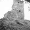
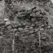
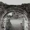
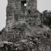
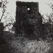
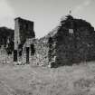
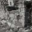
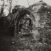
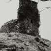
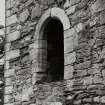
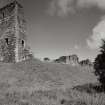
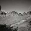
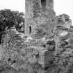
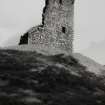
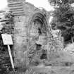
Toward Castle consists of a probably 15th century keep with a later courtyard extending to the NE. The keep was apparently rectangular, 39' x c.28', but as the N wall is completely buried in its own ruins, it is not possible to ascertain whether there was any projection approaching the L-plan. It probably stood four storeys high, the ground and hall floors being vaulted.
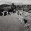
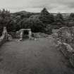
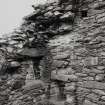
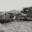
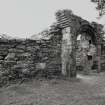
The later buildings are of considerable interest, and, including the keep, measure along the NE front 119'6" by c.80' wide, and are grouped to form a courtyard with buildings on two sides, the old keep at the S end and an enclosing wall along the NW side. In 1646, the castle, in the possession of the Lamonts, was besieged by the Campbells, and forced to surrender, when many Lamonts were hanged. It is supposed never to have been used again after that event.
About 1821, 200-300 small silver coins 'of an early Scottish reign' were found within the ruin.
J C Roger 1859; D MacGibbon and T Ross 1891.
Toward Castle is as described.
Earthworks revised at 1/2500.
Visited by OS (IA) 1 March 1973
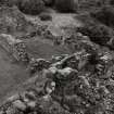
Custodianship of this ruin has been vested in the Clan Lamont Society, and a programme of rehabilitation undertaken. The E range has proved to be a hall-house of approximately 1630; its N end was apparently repaired and reoccupied temporarily after the 1646 siege. the building east of the entrance seems to have been a chapel; its south wall has been robbed to its foundations.
H B Millar 1972; 1974
Toward Castle (name not confirmed) is generally as described and planned, although MacGibbon and Ross's text is confusing because of an error in the cardinal points, the 15th century keeps lying to the south of the later range of buildings.
With the exception of the keep, which has yet ot be consolidated, the remains are well-preserved.
Surveyed at 1/2500.
Visited by OS (TRG) 20 October 1976
The remainder of the hall-house hall and solar floors were excavated to original levels; a large and varied quantity of artefacts was recovered, largely dating from the siege of 1646. Most of the metal objects are with Glasgow University; the remainder at Castle Cary. The floors have been re-covered with earth. The site of a well was revealed in the courtyard.
H Millar 1979.
Field Visit (May 1987)
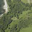
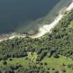
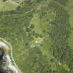
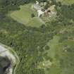
The ruins of the principal stronghold of the Lamont family are situated on the S shore of the East Cowal peninsula, in the wooded grounds E of the baronial mansion of Castle Toward (No. 158), and 400m SE of the former Campbell residence of Old Auchavoulin House (No. 154). The castle stands on a rocky promontory associated with old sea-cliffs 150m N of the shore of the Firth of Clyde, commanding a wide view of the Ayrshire mainland and the islands of Bute and Cumbrae. The area around the base of the promontory retains evidence of an encampment of World War II, and N of the castle and the raised-beach levels the ground rises gently to the distant Toward Hill.
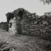
The nucleus of the castle was an oblong tower-house occupying the S edge of the steeply-scarped promontory; it stands fully three storeys in height at the SE angle but much of the remainder has collapsed, some fragments of masonry having fallen down the slope. The tower, which probably dates from the mid- or late 15th-century, is associated with a rectangular enclosure or courtyard whose N side incorporates a gatehouse range, while its E side is occupied by a single-storeyed hall-and-kitchen range. These N and E ranges evidently date from the late 16th or early 17th century, and there are indications of other minor 17th-centurymodifications throughout the castle, which was captured and burnt by a Campbell force in 1646 and, by tradition, has not been occupied since. Parts of the structure appear to have been consolidated and repaired in the 19th century and further excavation and consolidation took place in the1970s (en.1).
RCAHMS 1992, visited May 1987
[A full architectural description and historical note is provided in RCAHMS 1992, 297-302]
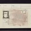
Measured Survey (29 May 1987)
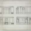
RCAHMS surveyed Toward Castle on 29 May 1987 producing a plan, section and elevation of the gateway at a scale of 1:20. The plan and sections were redrawn in ink and published at a scale of 1:50 (RCAHMS 1992, 301A).
Measured Survey (1987)
RCAHMS surveyed Toward Castle in 1987 with plane-table and alidade producing ground-, first- and second-floor plans at a scale of 1:100. The plans were redrawn in ink and published at a scale of 1:250 (RCAHMS 1992, 298C).
Measured Survey (1987)
RCAHMS surveyed Toward Castle in 1987 producing a plan, an interior and exterior sectional elevation and a section of the fireplace in the east range at a scale of 1:20. The plan and sections were redrawn in ink and published at a scale of 1:50 (RCAHMS 1992, 300B).

