Ardtaraig
Chapel (Early Medieval)
Site Name Ardtaraig
Classification Chapel (Early Medieval)
Canmore ID 40517
Site Number NS08SE 2
NGR NS 05662 82683
Datum OSGB36 - NGR
Permalink http://canmore.org.uk/site/40517
- Council Argyll And Bute
- Parish Inverchaolain
- Former Region Strathclyde
- Former District Argyll And Bute
- Former County Argyll
Site of chapel and incised cross at Ardtarig.
Argyll County Council 1914
NS 056 828. The chapel at Ardtarig may be of early medieval date and connected with the estate. There is an upright stone on the W edge of the chapel with an incised cross on one side and faint cup marks on the other.
M Paterson 1970
Field Visit (7 March 1973)
NS 0569 8268. The remains of this chapel are oriented NE SW and measure 10m x 5.6m with walls 0.6m high and 0.6m wide. The remains are enclosed by an earth and stone bank now reduced to a low stony scarp on all but the N side where it stands up to 0.6m high. The upright stone is a flat slab measuring 1m high x 0.5m wide and is inscribed with a Latin Cross. The cup marks are probably natural.
Surveyed at 1/2500.
Visited by OS (IA) 7 March 1973
Field Visit (13 October 1976)
As described in the report above.
Surveyed at 1:10,000.
Visited by OS (TRG) 13 October 1976
Measured Survey (1 August 1986)
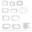
RCAHMS surveyed Ardtaraig chapel on 1 August 1986 with plane-table and alidade producing a plan at a scale of 1:100. The plan was redrawn in ink and published at a scale of 1:1000 (RCAHMS 1992, 49B), it was also redrawn for inclusion in a comparative sheet of chapels published at a scale of 1:250 (RCAHMS 1992, 6K).
Field Visit (September 1986)
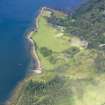
The remains of this chapel stand within a subrectangular enclosure on a terrace 150m from the E shore of Loch Striven and the same distance W of Ardtaraig House. The enclosure measures about 18m from ENE to WSW by 16.5m within an earth bank with intermittent facing-stones, now reduced to a low scarp except on the N, where it has a maximum height of 0.6m. The entrance was in the W wall, and its S jamb is formed by a carved stone of Early Christian type, probably not in its original position.
The chapel itself measures 9m from ENE to WSW by 4m, within drystone walls 0.8m thick whose uniform height of about 0.6m is due to clearance and consolidation about 1925. Its entrance is in the N wall, and there is a cross wall of uncertain significance 1m from the W end-wall.
The carved stone is a roughly rectangular slab of mica-schist 0.95m in visible height by 0.58m by 0.2m in thickness, has been broken across and repaired with mortar. The N face bears the pecked and grooved outline of a Latin cross, appparently open at the foot. On the S face there are several cup-marks, probably caused by natural weathering.
RCAHMS 1992, visited September 1986


