
Eilean Buidhe


Dun (Prehistoric)
Site Name Eilean Buidhe
Classification Dun (Prehistoric)
Canmore ID 40458
Site Number NS07NW 4
NGR NS 0186 7532
Datum OSGB36 - NGR
Permalink http://canmore.org.uk/site/40458


- Council Argyll And Bute
- Parish Inverchaolain
- Former Region Strathclyde
- Former District Argyll And Bute
- Former County Argyll
NS07NW 4 0186 7532.
(NS 0187 7532) Fort (NR) (Vitrified)
OS 6" map, Argyllshire, 2nd ed., (1900)
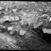
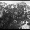
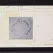
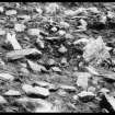
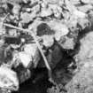
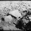
The vitrified dun (Feachem 1963) on Eilean Buidhe measures 71' E-W by 66' transversely from crest to crest of its broken-down wall. Maxwell's excavations showed that where Hewison suggested there had been 'towers', it was only a butressing of the foundation course necessitated by the slop of the rock. He stripped a large area at the W side of the dun, revealing a rough paving of stones, apparently constructed to fill a hollow space in the rock floor of the fort. Among the paving stones, he found a few pieces of vitrified rock, suggesting that the paving had been laid at a later period of occupation, when the wall was partly demolished. Hewison (1893) postulated an entrance in the ENE, but excavatiions there came upon a mass of vitrified rock continuous with the vitrified core on either side, disproving it, but excavation in the NNE-'3' on plan suggested a 3-5" wide gateway there.
A small hollow, perhaps a well or cistern, situated midway between the centre and the S point of the dun was emptied of water and cleared of silt, within a day it had refilled with water. No artifacts were found.
Sources: J K Hewison 1893; J H Maxwell 1941; R W Feachem 1963.
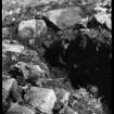
The walls of this fort are now overgrown with grass but it is otherwise as described.
Surveyed at 1/2500.
Visited by OS (I A) 30 November 1972.
Measured Survey (30 September 1983)
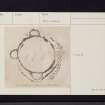
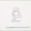
RCAHMS surveyed Eilean Buidhe dun on 30 September 1986 with plane-table and alidade producing a plan at a scale of 1:100. The plan of the dun was redrawn in ink and published at a scale of 1:250 (RCAHMS 1988a, 193).
Field Visit (November 1986)
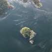
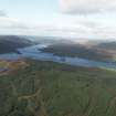
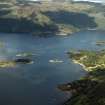
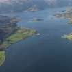
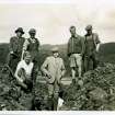
Situated at the SW end of Eilean Buidhe, one of the Burnt Isles at the N tip of the Kyle of Bute, and 350m S of Caol Ruadh, there is a vitrified dun. Approximately circular on plan, the dun measures about 19.5m in diameter within a wall some 4m in thickness; it was excavated by J H Maxwell in 1936 and, as the site is now heavily overgrown, this account and the plan are largely based upon the published report (Maxwell 1941). Two stretches of inner facing-stones were discovered on the N and on the W, and investigation of the core of the wall revealed large quantities of vitrified material forming a band up to 1.5m thick. The entrance probably lay within the gap in the wall on the NNE, but the evidence was inconclusive. Excavations in the interior uncovered a layer of charcoal, which extended beneath the inner face of the wall, as well as areas of rough paving, but no traces of internal strctures were identified. A small hollow or cistern 'about mid-way between the centre of the fort and the south point', first noted in 1822 (Trans Royal Soc of Edinburgh 1824), was emptied of water and cleared of silt, but no relics were found. When the site was described in the last century features interpreted as the bases of towers were recorded abutting the outer wall of the dun at the cardinal points of the compass (Hewison 1893); Maxwell's excavations, however, provided no evidence for the existence of such structures, though scatters of rubble from the dun wall were encountered at these points.
Visited November 1986
RCAHMS 1988
Field Visit (18 September 2010)
This vitrified dun, which was heavily overgrown on the date of visit, is as described. The wall has spread to a thickness of up to 6m in places and stands to a maximum height of 1.5m on the E side. Vitrified core material was visible in the ENE of the enclosing wall on the date of visit. The position of the entrance is unclear, as up to three of the excavation trenches breach the rampart at the N, NE and S. A partially backfilled trench is visible in the interior, adjacent to an area of exposed bedrock which was depicted on an early plan (Hewison 1893). The most recent published plan (RCAHMS 1988) is based on that produced by D N Marshall in 1936 (Maxwell 1941), amended after a brief site visit. There is no evidence for the four towers depicted by Hewison, which attracted Maxwell’s interest.
Visited by RCAHMS (GFG) 18 September 2010.

