
Pricing Change
New pricing for orders of material from this site will come into place shortly. Charges for supply of digital images, digitisation on demand, prints and licensing will be altered.
Bute, Kilchousland Chapel


Chapel (Medieval), Cross Base (Early Medieval), Enclosure (Period Unassigned)
Site Name Bute, Kilchousland Chapel
Classification Chapel (Medieval), Cross Base (Early Medieval), Enclosure (Period Unassigned)
Canmore ID 40436
Site Number NS06SW 3
NGR NS 03660 62646
Datum OSGB36 - NGR
Permalink http://canmore.org.uk/site/40436


- Council Argyll And Bute
- Parish North Bute
- Former Region Strathclyde
- Former District Argyll And Bute
- Former County Buteshire
NS06SW 3 03660 62646.
(NS 0366 6263) Kilchousland Chapel (NR) (Rems of)
OS 6" map (1957)
The authority for the OS name is unknown, the relevant ONB having been destroyed during the 1939-45 war. It is called Cruiskland Chapel by Blain and Hewison following him. Oriented slightly N of E, it measures some 36' x 21' 6" over 3' - 3'6" thick walls which stand 3' - 4' high, bonded by clay. The door was in the middle of the S wall. Hewison notes that the huge stones of a wall which formerly enclosed the graveyard are still visible. (The dedication is not given by Origines, but Watson, referring to Kilchousland in Kintyre, gives a dedication to St Constantin).
J Blain 1880; J K Hewison 1893; Orig Paroch Scot 1854; W J Watson 1926
NS 0366 6264. Kilchousland Chapel (name not verified) is situated on a level raised beach some 10.0m to the W of the base of a coastal cliff. It measures 8.3m ENE-WSW by 4.1m internally and has a stone wall 1.0m wide, now up to 1.2m high, much of which has tumbled into the interior. The entrance on the S wall is clearly defined. Slight traces of walling to the W may be the remains of the graveyard wall.
Surveyed at 1:10 000.
Visited by OS (TRG) 10 November 1976
NS 0365 6265 Chapel ruins: Located at foot of cliff 400m W of Nether Ardroscadale farmhouse. There are the walls of a substantial rectangular building, 10.5 x 5.5m internal, with 1m thick stone walls with clay bonding. Aligned downhill. There is a large old ash tree near E end. Inside semi-circular dyked enclosure. Alleged by May, Blain, et al to have been a chapel. May refers to adjacent field on cliff top to E as 'Chapell Croft'. Dedication is probably to Constantin, probably of Kilchousland in Kintyre.
Information from Bute Natural History Society Deserted Settlement Survey (1991-9)
(RCAHMS WP000273)
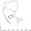
This chapel is situated at the foot of a raised beach cliff about 350m from the shore and 300m W of Nether Ardroscadale farmsteading. Rectangular on plan, it measures 9.1m from ENE to WSW by 5.3m transversely within walls 1.1m in thickness and up to 1.2m in height, with an entrance close to the middle of the SSE side. The ash tree mentioned in a previous report has fallen and the interior and surrounding ground, including the bank of the enclosure in which the chapel stands, have been heavily trampled by cattle.
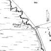
The chapel is depicted in an area labelled ‘Billie's Bog’ on a late 18th century estate map of Nether Ardroscadale (May 1780-82). The chapel and the enclosure bank are also shown on the 1st edition of the OS 25-inch map (Argyllshire and Buteshire 1869, Sheet CCIII.16) and the chapel was described in the contemporary OS Name Book as 'a small oblong building in ruins’ (No.6, p.51).
Visited by RCAHMS (GFG, JMH) 6 May 2009.
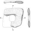
A fragment of what is probably a medieval cross base was discovered here by J Herriot in 2010. The fragment, which is located on the enclosing bank immediately W of the chapel, was drawn in detail by J Borland in October 2010.
Information from RCAHMS (GG) 14 April 2011.
Reference (1854)
Field Visit (1863)
Reference (1880)
Reference (1893)
Reference (1926)
Desk Based Assessment (18 June 1976)
(NS 0366 6263) Kilchousland Chapel (NR) (Rems of)
OS 6" map (1957)
(The authority for the OS name is unknown, the relevant ONB having been destroyed during the 1939-45 war). It is called Cruiskland Chapel by Blain and Hewison following him. Oriented slightly N of E, it measures some 36' x 21' 6" over 3' - 3'6" thick walls which stand 3' - 4' high, bonded by clay. The door was in the middle of the S wall. Hewison notes that the huge stones of a wall which formerly enclosed the graveyard are still visible. (The dedication is not given by Origines, but Watson, referring to Kilchousland in Kintyre, gives a dedication to St Constantin).
Information from OS (IF) 18 June 1976
J Blain 1880; J K Hewison 1893; Orig Paroch Scot 1854; W J Watson 1926
Field Visit (10 November 1976)
NS 0366 6264. Kilchousland Chapel (name not verified) is situated on a level raised beach some 10.0m to the W of the base of a coastal cliff. It measures 8.3m ENE-WSW by 4.1m internally and has a stone wall 1.0m wide, now up to 1.2m high, much of which has tumbled into the interior. The entrance on the S wall is clearly defined. Slight traces of walling to the W may be the remains of the graveyard wall.
Surveyed at 1:10 000, enlargement at 1:1000
Visited by OS (TRG) 10 November 1976
Field Visit (1991 - 1999)
NS 0365 6265 Chapel ruins: Located at foot of cliff 400m W of Nether Ardroscadale farmhouse. There are the walls of a substantial rectangular building, 10.5 x 5.5m internal, with 1m thick stone walls with clay bonding. Aligned downhill. There is a large old ash tree near E end. Inside semi-circular dyked enclosure. Alleged by May, Blain, et al to have been a chapel. May refers to adjacent field on cliff top to E as 'Chapell Croft'. Dedication is probably to Constantin, probably of Kilchousland in Kintyre.
Information from Bute Natural History Society Deserted Settlement Survey (1991-9)
(RCAHMS WP000273)
Field Visit (6 May 2009)
This chapel is situated at the foot of a raised beach cliff about 350m from the shore and 300m W of Nether Ardroscadale farmsteading. Rectangular on plan, it measures 9.1m from ENE to WSW by 5.3m transversely within walls 1.1m in thickness and up to 1.2m in height, with an entrance close to the middle of the SSE side. The ash tree mentioned in a previous report has fallen and the interior and surrounding ground, including the bank of the enclosure in which the chapel stands, have been heavily trampled by cattle.
The chapel is depicted in an area labelled ‘Billie's Bog’ on a late 18th century estate map of Nether Ardroscadale (May 1780-82). The chapel and the enclosure bank are also shown on the 1st edition of the OS 25-inch map (Argyllshire and Buteshire 1869, Sheet CCIII.16) and the chapel was described in the contemporary OS Name Book as 'a small oblong building in ruins’ (No.6, p.51).
Visited by RCAHMS (GFG, JMH) 6 May 2009.
Measured Survey (15 March 2010)
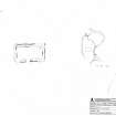
RCAHMS surveyed Kilchousland Chapel, Bute on 15 March 2010 with plane table and alidade producing a plan at a scale of 1:100. A site plan at the scale of 1:500 was also produced. The site plan was redrawn in vector graphics software for publication at a scale of 1:1000 (Geddes and Hale 2010, 32).
Measured Survey (14 October 2010)
Measured drawing of the socket stone.
Magnetometry (24 July 2011)
NS 03660 62646, NS 04539 67269 and NS 10004 56658 On the 24 July 2011 a gradiometry survey were undertaken at the four sites of Kilchousland, Kilchatten, East St Colmac Chapel and St Colmac. This work represents the start of the Christian Sites of the Atlantic Rim research project (CSAR).
Archive: Rose Geophysical Consultants
Funder: Rose Geophysical Consultants, British Academy and Discover Bute Landscape Partnership
Rose Geophysical Consultants 2011
Earth Resistance Survey (24 July 2011)
NS 03660 62646, NS 04539 67269 and NS 10004 56658 On the 24 July 2011 a resistivity survey were undertaken at the four sites of Kilchousland, Kilchatten, East St Colmac Chapel and St Colmac. This work represents the start of the Christian Sites of the Atlantic Rim research project (CSAR).
Archive: Rose Geophysical Consultants
Funder: Rose Geophysical Consultants, British Academy and Discover Bute Landscape Partnership
Rose Geophysical Consultants 2011
Project (24 July 2011)
NS 03660 62646, NS 04539 67269 and NS 10004 56658 On the 24 July 2011 gradiometry and resistance surveys were undertaken at the four sites of Kilchousland, Kilchatten, East St Colmac Chapel and St Colmac. This work represents the start of the Christian Sites of the Atlantic Rim research project (CSAR) which, aided by a small grant from the British Academy, aims to answer the question ‘can geophysics alone identify and date chapel sites?’ The project has initially chosen to concentrate on the ‘Celtic’ church and has begun by focusing on the Isle of Bute, as it represents a discrete geographic area and appears to have an abundance of ‘lost’ chapel sites.
The gradiometry survey was employed to identify and discount sites with a ‘domestic’ signature, on the assumption that these sites were either farmsteads or more complex monastery sites. The resistance survey aimed to determine the form and layout of sites, which it is hoped would be indicative of their age. Of the four sites surveyed the results suggest one ‘no show’, one ‘surprising turn up’, one ‘interesting results; possible need for further work’ and one ‘raises more questions than it answers’. However, it is hoped that the surveys have added to Bute's archaeological record. Certainly one completely new site has been located (St Colmac); East St Colmac would bear further investigation with the potential for cists and/or burials and a tentative chapel, and Kilchatten has been confirmed as a large prehistoric monument. In terms of the CSAR Project it could be argued that two sites provide data that confirm the efficacy of the techniques and provide dates, though of a broad spread.
Archive: Rose Geophysical Consultants
Funder: Rose Geophysical Consultants, British Academy and Discover Bute Landscape Partnership
Rose Geophysical Consultants 2011

