
Bute, Barone Hill


Fort (Period Unassigned)
Site Name Bute, Barone Hill
Classification Fort (Period Unassigned)
Canmore ID 40424
Site Number NS06SE 9
NGR NS 06964 63081
Datum OSGB36 - NGR
Permalink http://canmore.org.uk/site/40424


- Council Argyll And Bute
- Parish North Bute
- Former Region Strathclyde
- Former District Argyll And Bute
- Former County Buteshire
NS06SE 9 06964 63081
(NS 0696 6306) Earthwork (NR)
OS 6" map (1957)
See also NS06SE 27 (battle site).
For triangulation pillar within fort (at NS 06963 63089), see NS06SE 410.
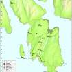
Barone Hill: This oval fort measures 200' x 145' within two ruinous, much robbed dry-stone walls, both 10'-12' thick. The inner wall is best preserved in the SE, where the massive stones stand 3' high, and, according to Hewison, show signs of vitrification, but no confirmation of this is on record.
J K Hewison 1893; R W Feachem 1963.
The fort occupies a commanding position on the summit of Barone Hill. It comprises the remains of an oval stone wall (enclosing an area 62.0m NE-SW by 42.0m) with an outer stone wall on the W and S whilst rocky precipitopus slopes form an additional defence on the E.
The oval wall survives on the W and S where it is 3.0m wide and up to 1.0m high with many facing stones in situ but there are only faint traces of it on the E. The entrance, though not apparent, was most probably at the 4.0m gap on the S side, which is now utilized by the modern wall. There is no evidence of the vitrification mentioned by Hewison.
The outer wall now commences 20.0m from the oval wall on the W side and runs due S for 90.0m before petering out in rocky terrain. It is 0.5m high and spread to 3.5m with several large inner facing stones in situ. In the SW there is a 2.0m wide entrance lined with several large stones. The wall cannot be traced to the S and E but the top of the steep slopes clearly define this side of the fort.
Surveyed at 1:2500.
Visited by OS (TRG) 23 November 1976.
On the date of visit, the SE part of this fort was shrouded in rank heather and little of the detail noted by previous authorities could be substantiated. However, to the NW of the stone wall that traverses the site from NNE to SSW, the fort appears to be generally as described by the OS. The summit of the hill is surmounted by an OS concrete triangulation pillar (NS06SE 410).
Visited by RCAHMS (AGCH, JH) 22 April 2009.
Field Visit (21 May 1943)
This site was included within the RCAHMS Emergency Survey (1942-3), an unpublished rescue project. Site descriptions, organised by county, vary from short notes to lengthy and full descriptions and are available to view online with contemporary sketches and photographs. The original typescripts, manuscripts, notebooks and photographs can also be consulted in the RCAHMS Search Room.
Information from RCAHMS (GFG) 10 December 2014.
Desk Based Assessment (4 July 1972)
(NS 0696 6306) Earthwork (NR)
OS 6" map (1957)
Barone Hill: This oval fort measures 200' x 145' within two ruinous, much robbed dry-stone walls, both 10'-12' thick. The inner wall is best preserved in the SE, where the massive stones stand 3' high, and, according to Hewison, show signs of vitrification, but no confirmation of this is on record.
Information from OS (IF) 4 July 1972
R W Feachem 1963; J K Hewison 1893
Field Visit (23 November 1976)
The fort occupies a commanding position on the summit of Barone Hill. It comprises the remains of an oval stone wall (enclosing an area 62.0m NE-SW by 42.0m) with an outer stone wall on the W and S whilst rocky precipitopus slopes form an additional defence on the E.
The oval wall survives on the W and S where it is 3.0m wide and up to 1.0m high with many facing stones in situ but there are only faint traces of it on the E. The entrance, though not apparent, was most probably at the 4.0m gap on the S side, which is now utilized by the modern wall. There is no evidence of the vitrification mentioned by Hewison.
The outer wall now commences 20.0m from the oval wall on the W side and runs due S for 90.0m before petering out in rocky terrain. It is 0.5m high and spread to 3.5m with several large inner facing stones in situ. In the SW there is a 2.0m wide entrance lined with several large stones. The wall cannot be traced to the S and E but the top of the steep slopes clearly define this side of the fort.
Surveyed at 1:2500.
Visited by OS (TRG) 23 November 1976
Field Visit (22 April 2009)
On the date of visit, the SE part of this fort was shrouded in rank heather and little of the detail noted by previous authorities could be substantiated. However, to the NW of the stone wall that traverses the site from NNE to SSW, the fort appears to be generally as described by the OS. The summit of the hill is surmounted by an OS concrete triangulation pillar (NS06SE 410).
Visited by RCAHMS (AGCH, JH) 22 April 2009.
Note (10 July 2014 - 23 May 2016)
This fort, which is situated on the rocky crest of Barone Hill, displays two divergent lines of enclosure, almost certainly representing separate phases of construction. The smaller enclosure is oval on plan and takes in the summit. measuring about 62m from NE to SW by 42m transversely (0.2ha) within a wall some 3m thick and up to 1m in height; this wall is best preserved on the W and S, where numerous facing-stones are visible, but elsewhere there is little more than a rickle of stones around the edge of the summit. The entrance is on the SW and the interior is featureless. The larger enclosure also once took in the summit, but extends down the crest of the hill towards the SSW to form a pear-shaped enclosure measuring some 130m in length by about 75m in maximum breadth (0.7ha) within a wall about 3m in thickness and 0.5m in height. Occasional facing-stones can be seen along its length and an entrance in the western side was noted in 1943. The relationship between the two perimeters is unknown, though on the NW the outer turns sharply back to meet the line of the inner at right-angles.
Information from An Atlas of Hillforts of Great Britain and Ireland – 23 May 2016. Atlas of Hillforts SC1172

