Bute, Loch Dhu
Crannog (Period Unassigned)
Site Name Bute, Loch Dhu
Classification Crannog (Period Unassigned)
Alternative Name(s) Dhu Loch
Canmore ID 40380
Site Number NS06SE 16
NGR NS 06634 61766
Datum OSGB36 - NGR
Permalink http://canmore.org.uk/site/40380
- Council Argyll And Bute
- Parish North Bute
- Former Region Strathclyde
- Former District Argyll And Bute
- Former County Buteshire
NS06SE 16 06634 61766.
(NS 0664 6176) Lake Dwelling (NR) (Site of) (NAT)
OS 6" map (1957)
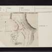
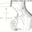
The remains of a crannog can be seen on the Dhu Loch. Constructed of wooden piles and beams, it was planned by Mackinlay in 1812 and 1826 when the water level was exceptionally low.
J Mackinlay 1862; I S Munro 1973
The remains of the crannog were completely submerged when the Dhu Loch was dammed to form a reservoir in the early 20th century. The water level was again raised in 1932 when the dam was heightened and nothing can now be seen.
Visited by OS (TRG) 2 November 1976.
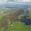
Loch Dhu reservoir forms part of the water supply to Rothesay and the crannog at its NE end has not been visible since the water level was raised early in the 20th century.
Visited by RCAHMS (AGCH, JH) 21 April 2009.
Field Visit (1812)
Field Visit (1826)
Reference (1862)
Reference (1893)
Reference (1973)
Desk Based Assessment (24 June 1976)
(NS 0664 6176) Lake Dwelling (NR) (Site of) (NAT)
OS 6" map (1957)
The remains of a crannog can be seen on the Dhu Loch. Constructed of wooden piles and beams, it was planned by Mackinlay in 1812 and 1826 when the water level was exceptionally low.
Information from OS (IF) 24 June 1976
J Mackinlay 1862; I S Munro 1973
Field Visit (2 November 1976)
The remains of the crannog were completely submerged when the Dhu Loch was dammed to form a reservoir in the early 20th century. The water level was again raised in 1932 when the dam was heightened and nothing can now be seen.
Visited by OS (TRG) 2 November 1976.
Reference (2003)
Field Visit (21 April 2009)
Loch Dhu reservoir forms part of the water supply to Rothesay and the crannog at its NE end has not been visible since the water level was raised early in the 20th century.
Visited by RCAHMS (AGCH, JH) 21 April 2009.


