
Pricing Change
New pricing for orders of material from this site will come into place shortly. Charges for supply of digital images, digitisation on demand, prints and licensing will be altered.
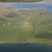
Bute, Colmac Bridge


Standing Stone (Prehistoric)
Site Name Bute, Colmac Bridge
Classification Standing Stone (Prehistoric)
Canmore ID 40360
Site Number NS06NW 5
NGR NS 04913 67160
Datum OSGB36 - NGR
Permalink http://canmore.org.uk/site/40360


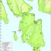


- Council Argyll And Bute
- Parish North Bute
- Former Region Strathclyde
- Former District Argyll And Bute
- Former County Buteshire
NS06NW 5 04913 67160.
(NS 0492 6716) Standing Stone (NR)
OS 6" map (1957)
Hewison lists a standing stone south of East Colmac. Rev A McBride of Kames considered it to be one of a stone circle, similar to NS06NW 3, but there are no other stones to be seen.
J K Hewison 1893; Name Book 1863
A standing stone situated in level pasture land is 1.9m high, 1.0m broad and 0.4m thick. There is no evidence to suggest that it was part of a stone circle.
Surveyed at 1/2500.
Visited by OS (TRG) 24 November 1976
Field Visit (1864 - 1865)
Reference (1893)
Field Visit (22 March 1943)
This site was recorded as part of the RCAHMS Emergency Survey, undertaken by Angus Graham and Vere Gordon Childe during World War 2. The project archive has been catalogued during 2013-2014 and the material, which includes notebooks, manuscripts, typescripts, plans and photographs, is now available online.
Information from RCAHMS (GF Geddes) 2 December 2014.
Field Visit (24 November 1976)
A standing stone situated in level pasture land is 1.9m high, 1.0m broad and 0.4m thick. There is no evidence to suggest that it was part of a stone circle.
Surveyed at 1/2500.
Visited by OS (TRG) 24 November 1976
Field Visit (20 May 2009)
This standing stone, which stands in a field of improved pasture 200m SW of the Colmac Bridge, is as described by the Ordnance Survey in 1976. First depicted on a 19th century estate map (RHP14262), and subsequently on the 1st edition of the OS 6-inch map (Buteshire 1869, Sheet CXCIV), the stone leans slightly to the E.
Visited by RCAHMS (GFG, PM) 20 May 2009.

