
Bute, Cnoc An Rath


Earthwork (Period Unassigned), Tomb (19th Century)
Site Name Bute, Cnoc An Rath
Classification Earthwork (Period Unassigned), Tomb (19th Century)
Alternative Name(s) Tomenraw
Canmore ID 40312
Site Number NS06NE 5
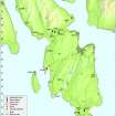
NGR NS 05363 67274
Datum OSGB36 - NGR
Permalink http://canmore.org.uk/site/40312


- Council Argyll And Bute
- Parish North Bute
- Former Region Strathclyde
- Former District Argyll And Bute
- Former County Buteshire
NS06NE 5 05363 67274.
(NS 0536 6725) Cnoc an Rath (NAT)
Earthwork (NR)
OS 6" map (1957)
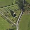
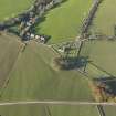
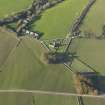
Cnoc an Rath, or Tom en Raw, consists of an irregular earthen circle, 91ft by 88ft in diameter, and a 10ft deep ditch. It is surrounded by a stone wall, built by Lord Bannatyne, and planted with firs, among which is the tomb of James Hamilton of Kames, 1775-1849.
J K Hewison 1893
'At Croc-an-Rath (054673) marked fort on 6" and earthwork on 1" the structure is probably a Neo Woodhenge type with a causeway. This is Jack Scott's idea and others agree' Information contained in a letter from D N Marshall to A L F Rivet of the OS Archaeology Division 29 September 1963 (MS1033.46).
Information from RCAHMS (GFG) 21 January 2010.
Though listed as a possible Class 1 henge (H A W Burl 1969), this classification is doubtful.
Information from J N G Ritchie, RCAHMS, 1972.
Early medieval Ring-work, previously classified as prehistoric, but it seems too fresh.
E J Talbot 1975
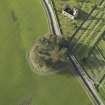
Cnoc an Rath (name verified), a sub-circular univallate earthwork situated on a slight rise in level pasture land. The inner bank, which has been effaced on the SW side, is up to 0.8m high internally and encloses a level area 24.0m in diameter. The well-preserved ditch is 1.6m deep on the north side. A 2.6m wide causeway crosses the bank and ditch in the east and ends at the outer enclosing wall where there is now a vertical drop of 1.6m. The 46.0m diameter stone wall which is from 1.0 to 1.8m high has damaged or destroyed the outer limits of the earth- work, and Miss Marshall suggests that there was formerly an outer bank. However, as Talbot suggests, the feature appears to be too well-defined to be anything other than medieval, probably a ring-work. The tomb is in poor condition.
Surveyed at 1/2500.
Visited by OS (TRG) 8 November 1976
An earthwork of uncertain purpose and age, but certainly not a 'fort' as described on the OS map. Roughly circular on plan it is bounded by a single deep ditch and internal upcast bank, and measures about 27 yds by 25 yds from crest to crest of the bank. There is a well-defined entrance on the E.
Although the structure has been tentatively identified as a henge, the ditch profile seems to be too steep and well-preserved for a prehistoric monument.
Information from K A Steer 14 July 1975.
NS 0536 6726 General survey of this circular earthwork was undertaken during October 2007. The elevated central area
surrounded by a ditch retains some evidence for a low bank along part of its circuit. The monument is surrounded by the
remains of a ha ha-like revetted bank, now much collapsed. The latter was partly superseded by a formally constructed wall to the N and NW. Along the S side of the site there is a low masonry platform, a stop on the late 19th-century tramway route that passed immediately adjacent. The early ditch may have been partly re-excavated.
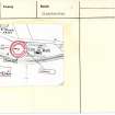
In the centre of the site lies the derelict 'Lone Man's Grave', a 19th-century burial enclosure of the Bannatynes of Kames. This structure was surveyed in detail.
Archive deposited with Bute Museum, RCAHMS, Mount Stuart Archive.
Funder: Discover Bute Landscape Partnership Scheme; partners HLF; SNH; The Mount Stuart Trust, Highlands and
Islands Enterprise, Argyll and Bute Council Buteshire Natural History Society; Community Council.
K Macfayden, S Philips and T Addyman, 2007.
This site is as previously described. An all-weather path, part of a walking/cycling route between Port Bannatyne and Ettrick Bay, skirts round its S side.
Visited by RCAHMS (AGCH) 20 March 2009.
Field Visit (1864 - 1865)
Reference (1880)
Reference (1893)
Cnoc an Rath, or Tom en Raw, consists of an irregular earthen circle, 91ft by 88ft in diameter, and a 10ft deep ditch. It is surrounded by a stone wall, built by Lord Bannatyne, and planted with firs, among which is the tomb of James Hamilton of Kames, 1775-1849.
J K Hewison 1893
Field Visit (22 March 1943)
This site was recorded as part of the RCAHMS Emergency Survey, undertaken by Angus Graham and Vere Gordon Childe during World War 2. The project archive has been catalogued during 2013-2014 and the material, which includes notebooks, manuscripts, typescripts, plans and photographs, is now available online.
Information from RCAHMS (GF Geddes) 2 December 2014.
Reference (29 September 1963)
'At Croc-an-Rath (054673) marked fort on 6" and earthwork on 1" the structure is probably a Neo Woodhenge type with a causeway. This is Jack Scott's idea and others agree'. Information contained in a letter from D N Marshall to A L F Rivet of the OS Archaeology Division 29 September 1963 (MS1033.46).
Information from RCAHMS (GFG) 21 January 2010.
Reference (1969)
Desk Based Assessment (10 August 1972)
Cnoc an Rath, or Tom en Raw, consists of an irregular earthen circle, 91ft by 88ft in diameter, and a 10ft deep ditch. It is surrounded by a stone wall, built by Lord Bannatyne, and planted with firs, among which is the tomb of James Hamilton of Kames, 1775-1849 (J K Hewison 1893).
Though listed as a possible Class 1 henge (H A W Burl 1969), this classification is doubtful (Information from J N G Ritchie, RCAHMS).
Information from OS (IF) 10 August 1972
Reference (26 September 1972)
Early medieval Ring-work, previously classified as prehistoric, but it seems too fresh.
Information from OS (ES) 26 September 1972
E J Talbot 'Mottes' TS.
Note (1972)
Though listed as a possible Class 1 henge (H A W Burl 1969), this classification is doubtful.
Information from J N G Ritchie, RCAHMS, 1972.
Reference (1974)
Field Visit (14 July 1975)
An earthwork of uncertain purpose and age, but certainly not a 'fort' as described on the OS map. Roughly circular on plan it is bounded by a single deep ditch and internal upcast bank, and measures about 27 yds by 25 yds from crest to crest of the bank. There is a well-defined entrance on the E.
Although the structure has been tentatively identified as a henge, the ditch profile seems to be too steep and well-preserved for a prehistoric monument.
Information from K A Steer 14 July 1975.
Field Visit (8 November 1976)
Cnoc an Rath (name verified), a sub-circular univallate earthwork situated on a slight rise in level pasture land. The inner bank, which has been effaced on the SW side, is up to 0.8m high internally and encloses a level area 24.0m in diameter. The well-preserved ditch is 1.6m deep on the north side. A 2.6m wide causeway crosses the bank and ditch in the east and ends at the outer enclosing wall where there is now a vertical drop of 1.6m. The 46.0m diameter stone wall which is from 1.0 to 1.8m high has damaged or destroyed the outer limits of the earth- work, and Miss Marshall suggests that there was formerly an outer bank. However, as Talbot suggests, the feature appears to be too well-defined to be anything other than medieval, probably a ring-work. The tomb is in poor condition.
Surveyed at 1/2500.
Visited by OS (TRG) 8 November 1976
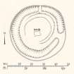
Measured Survey (3 November 1982)
RCAHMS surveyed the earthwork at Tomenraw by plane-table and alidade on 3 November 1982. The pencil drawing was redrawn in ink.
Reference (1987)
Ground Survey (August 2007)
NS 0536 6726 General survey of this circular earthwork was undertaken during October 2007. The elevated central area surrounded by a ditch retains some evidence for a low bank along part of its circuit. The monument is surrounded by the remains of a ha ha-like revetted bank, now much collapsed. The latter was partly superseded by a formally constructed wall to the N and NW. Along the S side of the site there is a low masonry platform, a stop on the late 19th-century tramway route that passed immediately adjacent. The early ditch may have been partly re-excavated.
In the centre of the site lies the derelict 'Lone Man's Grave', a 19th-century burial enclosure of the Bannatynes of Kames. This structure was surveyed in detail.
Archive deposited with Bute Museum, RCAHMS, Mount Stuart Archive.
Funder: Discover Bute Landscape Partnership Scheme; partners - HLF; SNH; The Mount Stuart Trust, Highlands and Islands Enterprise, Argyll and Bute Council Buteshire Natural History Society; Community Council.
Watching Brief (April 2009 - May 2010)
NS 05363 67274 A programme of works was undertaken April 2009–May 2010 at Cnoc an Rath as part of a four year programme to consolidate the scheduled ancient monuments on Bute. The planned consolidation forms part of a wider programme of landscape enhancement facilitated by the DBLPS.
A watching brief was undertaken in April 2009 during topsoil stripping for a new all-access walking and cycling path. The path was created broadly on the line of the disused Port Bannatyne to Ettrick Bay tramway and part of it skirted the E, S and W boundaries of Cnoc an Rath. No features of archaeological significance were recorded. Consolidation work was then undertaken to stabilise the surrounding dry stone boundary wall and repair the stonework and iron railings of the 19th-century tomb of James Hamilton of Kames. A photographic survey of both features was conducted prior to the start of this work.
Archive: Bute Museum and RCAHMS (intended)
Funder: Heritage Lottery Fund, Argyll and Bute Council and Historic Scotland
Paul Duffy – Discover Bute Landscape Partnership Scheme (DBLPS)
Field Visit (19 January 2010)
This site is as previously described. An all-weather path, part of a walking/cycling route between Port Bannatyne and Ettrick Bay, skirts round its S side.
Visited by RCAHMS (AGCH) 20 March 2009.
Earth Resistance Survey (23 May 2011 - 25 May 2011)
67274 A resistance geophysical survey was undertaken 23–25 May 2011 over Cnoc an Rath earthwork as part of a programme of community archaeology projects. The survey covered the interior, and the ditch and bank earthworks up to a 19th-century boundary wall which surrounds the site. The project aimed to help address key issues as to the character and origins of the monument, which place name evidence suggests could be a Viking legal assembly site or ting. A possible circular feature within the interior was indicated by a series of high resistance anomalies. This was located off-centre in the NE side of the central platform and 23m in diameter. Post-medieval reorganisation of the site limited the likelihood of historic features having survived and site clearance may be the source of the anomalies. The truncated remains of an enclosure associated with a ting site were also a possible interpretation.
Archive: RCAHMS and WoSAS (intended)
Funder: Discover Bute Landscape Partnership Scheme
OJT Surveys 2011
Excavation (May 2011 - June 2011)
A programme of investigation (DES 2010, 48 49) continued at the scheduled ancient monument of Cnoc an Rath between May and July 2011. The work formed part of the DBLPS’s programme of community archaeology projects for 2011.
A resistivity survey of the monument was undertaken by Dr Oliver O’Grady in May 2011 (see above entry).The results of this work aided in the production of the project design for a programme of excavation, which was undertaken 20 June–11 July 2011.
Three trenches were opened at the monument to examine the ditch, the bank and a proportion of the central area inside the bank. Frustratingly, few artefacts were recovered and there was no evidence of any structural features. Instead, evidence of re-cutting suggested that the ditches had been cleaned out, and the banks enhanced from ditch derived material in more modern times. A preliminary interpretation suggests that much of the visible form of the monument probably dates to the 18th century and later. The most probable candidate for this work is the last Lord Bannatyne of Kames, at the turn of the 18th century, though the next owner, James Hamilton of Kames may also have undertaken work. However, there remains the possibility that the work modified an earlier thing site, or prehistoric enclosure. A post-excavation programme is planned and a second phase of geophysics will investigate the surrounding area.
The excavation was an excellent training opportunity and over the three weeks of the excavation over 35 people volunteered over 200 days of work, many of whom were taking part in an excavation for the first time. Over 250 visitors also attended the excavations.
Archive: Bute Museum and RCAHMS (intended)
Funder: Discover Bute Landscape Partnership Scheme
Discover Bute Landscape Partnership Scheme 2011

