
Bute, Hilton


Chambered Cairn (Neolithic), Cist (Period Unassigned), Short Cist (Bronze Age)
Site Name Bute, Hilton
Classification Chambered Cairn (Neolithic), Cist (Period Unassigned), Short Cist (Bronze Age)
Alternative Name(s) Hilton Cairn; Hilton Farm
Canmore ID 40306
Site Number NS06NE 17
NGR NS 06665 68597
Datum OSGB36 - NGR
Permalink http://canmore.org.uk/site/40306


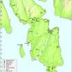


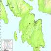


- Council Argyll And Bute
- Parish North Bute
- Former Region Strathclyde
- Former District Argyll And Bute
- Former County Buteshire
NS06NE 17 06665 68597
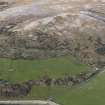
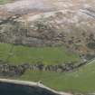
NS 067 685. Hilton Cairn was noticed by William Ritchie of Hilton Farm and pointed out to D N Marshall in 1972 who excavated a trial trench in November of that year. Excavations carried out between March 1973 and summer 1976 at what originally appeared as a circular area of turf-covered stones some 30.0m in diameter on the moor above Kames Bay revelaed a neolithic cairn roughly 5.5m in diameter with a central chamber, aligned NW-SE, measuring 0.9m by 0.5m. In a later phase, the cairn was extended, keeping to the original round plan. A further extension runs 18.0m downhill to a larger boulder, possibly ice-carried, which has been used to prevent slip. Live rock, very near the old land surface, has been adapted in places to the design of the cairn. A Bronze Age cist was inserted in the early neolithic cairn, and it, in turn, was surrounded by a small cairn. Artifacts found, i.e a crushed carinated bowl (Neo 2) and leaf-shaped flint arrowhead, a flint scraper and blade, and a tanged quartz point, are now in Rothesay Museum.
D N Marshall and W Ritchie 1972; D N Marshall 1973; D N Marshall 1974; D N Marshall 1975; D N Marshall 1976.
NS 0666 6857. The stripped cairn is situated on a SE facing hillslope in moorland. The excavation is still open and most of the cairn material is lying in small heaps around it. The stones of the chamber were disturbed during the excavation and later by animals (D Marshall, Kames Garden Cottage, Port Bannatyne), and are now recumbent at the N end of the cairn. Near the centre of the area, the Bronze Age cist is exposed; it measures 0.9m by 0.6m and is 0.6m deep. A recumbent stone 1.0m to the north appears to be its capstone. At the north and south extremities of the cairn, there are several slabs of living rock which were incorporated in its construction.
Cist surveyed at 1/2500.
Visited by OS (TRG) 24 November 1976
Now filled in.
Information from D Marshall, August 1984.
This cairn, which overlooks Kames Bay to the SE, is situated in rough ground about 500m ENE of Hilton farmsteading. Now heavily overgrown with gorse, the edge of an excavation trench, the kerb of the cairn and a cist are still clearly visible. The cairn was excavated by volunteers from the Bute Natural History Society and others between November 1972 and the summer of 1976 under the direction of D N Marshall with advice from J G Scott.
Visited by RCAHMS (GFG, PJD), 21 April 2009.
Trial Trench (19 November 1972)
In November of 1972, actually using school boys on the Queen's Silver Wedding holiday (17th November), a trial trench showed unmistakeable cairn material.
D N Marshall 1976.
Field Visit (1972)
Desk Based Assessment (28 June 1976)
NS 067 685. Excavations carried out between 1972 and 1975 at what originally appeared as a circular area of turf-covered stones some 30.0m in diameter on the moor above Kames Bay revelaed a neolithic cairn roughly 5.5m in diameter with a central chamber, aligned NW-SE, measuring 0.9m by 0.5m. In a later phase, the cairn was extended, keeping to the original round plan. A further extension runs 18.0m downhill to a larger boulder, possibly ice-carried, which has been used to prevent slip. Live rock, very near the old land surface, has been adapted in places to the design of the cairn. A Bronze Age cist was inserted in the early neolithic cairn, and it, in turn, was surrounded by a small cairn. Artifacts found, i.e a crushed carinated bowl (Neo 2) and leaf-shaped flint arrowhead, a flint scraper and blade, and a tanged quartz point, are now in Rothesay Museum.
Information from OS (IF) 28 June 1976
D N Marshall and W Ritchie 1972; D N Marshall 1973; 1974; 1975; 1976
Field Visit (24 November 1976)
NS 0666 6857. The stripped cairn is situated on a SE facing hillslope in moorland. The excavation is still open and most of the cairn material is lying in small heaps around it. The stones of the chamber were disturbed during the excavation and later by animals (D Marshall, Kames Garden Cottage, Port Bannatyne), and are now recumbent at the N end of the cairn. Near the centre of the area, the Bronze Age cist is exposed; it measures 0.9m by 0.6m and is 0.6m deep. A recumbent stone 1.0m to the north appears to be its capstone. At the north and south extremities of the cairn, there are several slabs of living rock which were incorporated in its construction.
Cist surveyed at 1/2500.
Visited by OS (TRG) 24 November 1976
Field Visit (21 April 2009)
This cairn, which overlooks Kames Bay to the SE, is situated in rough ground about 500m ENE of Hilton farmsteading. Now heavily overgrown with gorse, the edge of an excavation trench, the kerb of the cairn and a cist are still clearly visible. The cairn was excavated by volunteers from the Bute Natural History Society and others between November 1972 and the summer of 1976 under the direction of D N Marshall with advice from J G Scott.
Visited by RCAHMS (GFG, PJD), 21 April 2009.

