
Pricing Change
New pricing for orders of material from this site will come into place shortly. Charges for supply of digital images, digitisation on demand, prints and licensing will be altered.
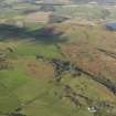
Bute, Kingavin


Corn Drying Kiln (Period Unassigned), Enclosure (Period Unassigned), Farmstead (Period Unassigned)
Site Name Bute, Kingavin
Classification Corn Drying Kiln (Period Unassigned), Enclosure (Period Unassigned), Farmstead (Period Unassigned)
Alternative Name(s) Kinnegaven
Canmore ID 40283
Site Number NS05SE 17
NGR NS 09480 53810
Datum OSGB36 - NGR
Permalink http://canmore.org.uk/site/40283


- Council Argyll And Bute
- Parish Kingarth
- Former Region Strathclyde
- Former District Argyll And Bute
- Former County Buteshire
NS05SE 17 09480 53810.
Kinnegaven.
Name Book 1863.
Kingaven.
Information contained in a letter from Miss D N Marshall to OS, 29 September 1963.
There is a corn-drying kiln at NS 0946 5385.
Surveyed at 1:10,000.
Visited by OS November 1976.
Recorded during survey of deserted settlements; records are held in the Bute Museum.
Sponsor: Bute Antiq Natur Hist Soc; St Andrews Heritage Services.
Hannah and Proudfoot 1994.
A township comprising four unroofed buildings and one enclosure is depicted on the 1st edition of the OS 6-inch map (Argyllshire and Buteshire 1869, sheet ccxxvii). Four unroofed buildings, one unroofed circular structure which may be a kiln and one enclosure are shown on the current edition of the OS 1:10000 map (1978).
Information from RCAHMS (AKK) 15 October 1998.
NS 094 538 Site 10 Kingavin
On the east side of a track 400m north of St Blane’s, this is one of the most easily accessible sites. In an enclosure are the remains of four houses and a corn kiln. This farm, which was a fraction of Branser (14), is in record from 1506 and was probably abandoned towards the end of the 18th century. It is unusual in Bute in that the buildings are contained in a single large enclosure instead of the usual arrangement where a small yard is associated with each house.
Proudfoot and Hannah 2000
NS 0948 5381 Farmstead remains: Located in broken moorland on E side of track 400m N of St Blane's Chapel. There is an enclosure with the foundations of 4 houses; three large have two cells and one is single celled building. There is also a corn kiln. This site is a well documented farm. It was a fraction of Branser in record from 1506.
Information from Bute Natural History Society Deserted Settlement Survey (1991-9)
(RCAHMS WP000273)
This farmstead, which is situated on uncultivated ground about 320m N of St Blane’s Church (NS05SE 5), comprises four buildings (all reduced to grass-grown footings), an enclosure and a corn-drying kiln. The farmstead is depicted on Roy’s Military Map (1747-55), but it is shown in more detail on a contemporary estate map (Foulis 1758-9) which shows two buildings standing on the SW side of an enclosure. Four unroofed buildings and an enclosure, annotated 'Kinnegaven (Ruins)', are depicted on the 1st edition of the OS 25-inch map (Buteshire 1869, Sheet CCXXVII.3).
Visited by RCAHMS (AGCH, IP) 18 March 2009.
Antiquarian Mapping (1747 - 1755)
Antiquarian Mapping (1758 - 1759)
Reference (29 September 1963)
Kingaven.
Information contained in letter from Miss D N Marshall to OS, 29 September 1963.
Field Visit (15 November 1976)
There is a corn-drying kiln at NS 0946 5385.
Surveyed at 1:10,000.
Visited by OS November 1976.
Field Visit (1991 - 1999)
Recorded during survey of deserted settlements; records are held in the Bute Museum.
Sponsor: Bute Antiq Natur Hist Soc; St Andrews Heritage Services.
Hannah and Proudfoot 1994.
NS 094 538 Site 10 Kingavin
On the east side of a track 400m north of St Blane’s, this is one of the most easily accessible sites. In an enclosure are the remains of four houses and a corn kiln. This farm, which was a fraction of Branser (14), is in record from 1506 and was probably abandoned towards the end of the 18th century. It is unusual in Bute in that the buildings are contained in a single large enclosure instead of the usual arrangement where a small yard is associated with each house.
Proudfoot and Hannah 2000
NS 0948 5381 Farmstead remains: Located in broken moorland on E side of track 400m N of St Blane's Chapel. There is an enclosure with the foundations of 4 houses; three large have two cells and one is single celled building. There is also a corn kiln. This site is a well documented farm. It was a fraction of Branser in record from 1506.
Information from Bute Natural History Society Deserted Settlement Survey (1991-9)
(RCAHMS WP000273)
Desk Based Assessment (15 October 1998)
A township comprising four unroofed buildings and one enclosure is depicted on the 1st edition of the OS 6-inch map (Argyllshire and Buteshire 1869, sheet ccxxvii). Four unroofed buildings, one unroofed circular structure which may be a kiln and one enclosure are shown on the current edition of the OS 1:10000 map (1978).
Information from RCAHMS (AKK) 15 October 1998.
Field Visit (18 March 2009)
The ruins of this township are situated in rough ground about 350m N of St Blane’s church (NS05SE 5) and are generally as described by the previous authority. They comprise four buildings, an enclosure and a corn-drying kiln. The largest of the buildings measures about 20m by 7m transversely overall. The site is depicted as two buildings on the SSW and ESE sides of an enclosed yard on a Foulis estate map (1758-9). Four houses and a yard are depicted on the 1st edition OS 25-inch map (Buteshire 1869, Sheet CCXXVII.3) and the site is annotated 'Kinnegaven (Ruins)'.
Visited by RCAHMS (AGCH, IP) 18 March 2009.

