
Pricing Change
New pricing for orders of material from this site will come into place shortly. Charges for supply of digital images, digitisation on demand, prints and licensing will be altered.
Upcoming Maintenance
Please be advised that this website will undergo scheduled maintenance on the following dates:
Thursday, 9 January: 11:00 AM - 3:00 PM
Thursday, 23 January: 11:00 AM - 3:00 PM
Thursday, 30 January: 11:00 AM - 3:00 PM
During these times, some functionality such as image purchasing may be temporarily unavailable. We apologise for any inconvenience this may cause.
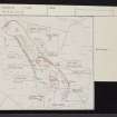
Bute, St Blane's


Socketed Stone (Early Medieval)
Site Name Bute, St Blane's
Classification Socketed Stone (Early Medieval)
Canmore ID 40277
Site Number NS05SE 10
NGR NS 09501 53522
Datum OSGB36 - NGR
Permalink http://canmore.org.uk/site/40277


- Council Argyll And Bute
- Parish Kingarth
- Former Region Strathclyde
- Former District Argyll And Bute
- Former County Buteshire
NS05SE 10 09501 53522.
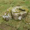
A rock, just outside the gateway in the cashel wall, has been roughly cut to form a base with a socket for a great Celtic cross.
S Cruden 1960; J K Hewison 1893-5.
A flat topped rock, measuring 0.7m by 0.8m by 0.6m high, with a rectangular socket 0.3m by 0.1m cut in it.
Surveyed at 1:10,000.
Visited by OS (B S) 11 November 1976.
Reference (1960)
Desk Based Assessment (21 July 1972)
A rock, just outside the gateway in the cashel wall, has been roughly cut to form a base with a socket for a great Celtic cross.
(S Cruden 1960; J K Hewison 1893-5).
Information from OS (IF) 21 July 1972
Field Visit (11 November 1976)
A flat topped rock, measuring 0.7m by 0.8m by 0.6m high, with a rectangular socket 0.3m by 0.1m cut in it.
Surveyed at 1:10,000.
Visited by OS (B S) 11 November 1976.
Field Visit (31 March 2010)
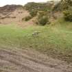
This socket stone, which is as described by the Ordnance Survey, is situated about 70m NNE of the ruined church (NS05SE 5), outside the enclosure wall and against a grass-grown field bank.
Visited by RCAHMS (GFG) 31 March 2010.
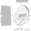
Measured Survey (14 October 2010)
A plan and sections of the stone were made by RCAHMS draughtsman John Borland.

