
Bute, Langalbuinoch


Field Boundary(S) (Period Unassigned), Plantation Bank (Period Unassigned), Rig And Furrow (Medieval) - (Post Medieval)
Site Name Bute, Langalbuinoch
Classification Field Boundary(S) (Period Unassigned), Plantation Bank (Period Unassigned), Rig And Furrow (Medieval) - (Post Medieval)
Alternative Name(s) Cropmark
Canmore ID 40244
Site Number NS05NE 21
NGR NS 08537 56995
Datum OSGB36 - NGR
Permalink http://canmore.org.uk/site/40244


- Council Argyll And Bute
- Parish Kingarth
- Former Region Strathclyde
- Former District Argyll And Bute
- Former County Buteshire
NS05NE 21 08537 56995.
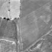
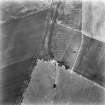
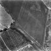
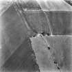
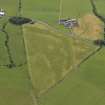
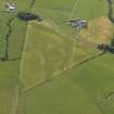
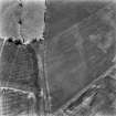
Aerial photography has recorded the cropmarks of the NW part of what may have been a roughly circular plantation enclosure 350m NE of Langalbuinoch farmsteading (NS05NE 104). The enclosure, which measured up to 55m across, but was open to the E, is depicted on a late 18th century estate map (Mitchell 1771), and the 1st edition of the OS 6-inch map (Buteshire 1869, Sheet CCXV). The cropmarks represent a narrow ditch that probably originally accompanied an inner bank; this bank-and-ditch is still preserved on the S in a current field boundary.
Within the enclosure are the cropmarks of rig-and-furrow, orientated N and S, and measuring roughly 8m in breadth between the furrows. Cropmarks of further rig, on different orientations, are visible immediately to the E.
Information from RCAHMS (GFG) 11 November 2009.
Note (11 November 2009)
Aerial photography has recorded the cropmarks of the NW part of what may have been a roughly circular plantation enclosure 350m NE of Langalbuinoch farmsteading (NS05NE 104). The enclosure, which measured up to 55m across, but was open to the E, is depicted on a late 18th century estate map (Mitchell 1771), and the 1st edition of the OS 6-inch map (Buteshire 1869, Sheet CCXV). The cropmarks represent a narrow ditch that probably originally accompanied an inner bank; this bank-and-ditch is still preserved on the S in a current field boundary.
Within the enclosure are the cropmarks of rig-and-furrow, orientated N and S, and measuring roughly 8m in breadth between the furrows. Cropmarks of further rig, on different orientations, are visible immediately to the E.
Information from RCAHMS (GFG) 11 November 2009.

