
Pricing Change
New pricing for orders of material from this site will come into place shortly. Charges for supply of digital images, digitisation on demand, prints and licensing will be altered.
Upcoming Maintenance
Please be advised that this website will undergo scheduled maintenance on the following dates:
Thursday, 9 January: 11:00 AM - 3:00 PM
Thursday, 23 January: 11:00 AM - 3:00 PM
Thursday, 30 January: 11:00 AM - 3:00 PM
During these times, some functionality such as image purchasing may be temporarily unavailable. We apologise for any inconvenience this may cause.
Bute, Dunagoil


Burial Cairn(S) (Bronze Age), Cist (Bronze Age)
Site Name Bute, Dunagoil
Classification Burial Cairn(S) (Bronze Age), Cist (Bronze Age)
Canmore ID 40070
Site Number NS05SE 13
NGR NS 08513 53159
Datum OSGB36 - NGR
Permalink http://canmore.org.uk/site/40070


- Council Argyll And Bute
- Parish Kingarth
- Former Region Strathclyde
- Former District Argyll And Bute
- Former County Buteshire
NS05SE 13 08513 53159
There are at least two cists and several mounds in the valley between Dunagoil (NS 084 531) and Little Dunagoil (NS 087 532). Two of the mounds were opened (in the 19th century) by Blain, who found bones.
(See NS05SE 7 and NS05SE 15 ).
J N Marshall 1915.
There is no trace of either cists or burial mounds in the area described by the previous authority. There is however a burial chamber (NS05SE7) at NS 087 532 and a group of field clearance cairns (NS05SE 15) at NS 087 531 and it is quite possible that Marshall's reference was to these features.
Visited by OS (B S) 22 November 1976
Measured Survey (1780)
Reference (1880)
Field Visit (25 May 1943)
This site was recorded as part of the RCAHMS Emergency Survey, undertaken by Angus Graham and Vere Gordon Childe during World War 2. The project archive has been catalogued during 2013-2014 and the material, which includes notebooks, manuscripts, typescripts, plans and photographs, is now available online.
Information from RCAHMS (GF Geddes) 2 December 2014.
Reference (31 August 1972)
There are at least two cists and several mounds in the valley between Dunagoil (NS 084 531) and Little Dunagoil (NS 087 532). Two of the mounds were opened (in the 19th century) by Blain, who found bones.
(See NS05SE 7, 15).
Information from OS (IF) 31 August 1972
Field Visit (22 November 1976)
There is no trace of either cists or burial mounds in the area described by the previous authority. There is however a burial chamber (NS05SE7) at NS 087 532 and a group of field clearance cairns (NS05SE 15) at NS 087 531 and it is quite possible that Marshall's reference was to these features.
Visited by OS (B S) 22 November 1976.
Field Visit (30 March 2009)
NS05SE 13 08513 53159
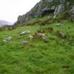
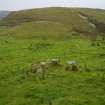
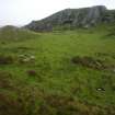
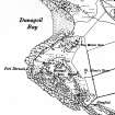
This cairn is situated on a terrace immediately NE of Dunagoil fort (NS05SE 4), amidst extensive rig-and-furrow (NS05SE 29). It comprises a grass-grown mound of stones measuring 5m in diameter by 0.5m in height over a discontinuous kerb of edge-set stones. Two other cairns of similar size lie about 50m to the N (NS 08509 53200 & NS 08518 53202).
The cairns are noted as antiquities on a plan of Dunagoil produced in 1780, probably by Peter or Alexander May (Anon 1780), and they are likely to be the same cairns referred to by both Blain in his History of Bute (Ross 1880, 78) and Marshall, who’s plan shows five mounds and a cist (1915, 44). Three mounds and a cist are depicted on the 3rd edition of the OS 6-inch map revised in 1915 (Buteshire 1924, Sheet CCXXVII). The cist, which was probably set within the eastern of the two other cairns noted above, is no longer visible.
Visited by RCAHMS (GFG, AGCH, GB) 30 March 2009.

