|
Photographs and Off-line Digital Images |
B 83528 PO |
Cambridge University Collection for Aerial Photography |
Loch Gair, Caibeal A'Bhride.
Oblique aerial view. |
|
Item Level |
|
 |
On-line Digital Images |
DP 112111 |
RCAHMS Aerial Photography Digital |
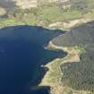
General oblique aerial view of Caibeal A' Bhride burial ground at Loch Gair, taken from the SSE. |
2/5/2011 |
Item Level |
|
 |
On-line Digital Images |
DP 112112 |
RCAHMS Aerial Photography Digital |
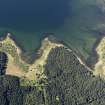
Oblique aerial view of Caibeal A' Bhride burial ground at Loch Gair, taken from the ENE. |
2/5/2011 |
Item Level |
|
 |
On-line Digital Images |
DP 112113 |
RCAHMS Aerial Photography Digital |
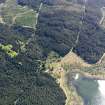
Oblique aerial view of Caibeal A' Bhride burial ground at Loch Gair, taken from the NW. |
2/5/2011 |
Item Level |
|
 |
Digital Files (Non-image) |
WP 003837 |
Publications by the Royal Commission on the Ancient and Historical Monuments of Scotland |
Argyll: An inventory of the monuments: volume 7: Mid-Argyll and Cowal: Medieval and later monuments |
1992 |
Item Level |
|
|
Photographs and Off-line Digital Images |
SC 1930442 |
Cambridge University Collection for Aerial Photography |
Loch Gair, Caibeal A'Bhride.
Oblique aerial view. |
|
Item Level |
|
 |
On-line Digital Images |
SC 2419724 |
Records of the Ordnance Survey, Southampton, Hampshire, England |
Loch Gair, Caibeal A' Bhride, NR99SW 7, Ordnance Survey index card, page number 1, Recto |
1958 |
Item Level |
|
 |
On-line Digital Images |
SC 2419725 |
Records of the Ordnance Survey, Southampton, Hampshire, England |
Loch Gair, Caibeal A' Bhride, NR99SW 7, Ordnance Survey index card, page number 2, Verso |
1958 |
Item Level |
|
 |
On-line Digital Images |
SC 2419726 |
Records of the Ordnance Survey, Southampton, Hampshire, England |
Loch Gair, Caibeal A' Bhride, NR99SW 7, Ordnance Survey index card, Recto |
1958 |
Item Level |
|
|
All Other |
551 166/1/1 |
Records of the Ordnance Survey, Southampton, Hampshire, England |
Archaeological site card index ('495' cards) |
1947 |
Sub-Group Level |
|


