
Loch Gair, Caibeal A' Bhride


Architectural Fragment (Medieval)(Possible), Burial Ground (Medieval), Chapel (Medieval), Gravestone(S) (18th Century)
Site Name Loch Gair, Caibeal A' Bhride
Classification Architectural Fragment (Medieval)(Possible), Burial Ground (Medieval), Chapel (Medieval), Gravestone(S) (18th Century)
Alternative Name(s) St Bride's Chapel; Kilbride
Canmore ID 40066
Site Number NR99SW 7
NGR NR 9347 9079
Datum OSGB36 - NGR
Permalink http://canmore.org.uk/site/40066


- Council Argyll And Bute
- Parish Kilmichael Glassary
- Former Region Strathclyde
- Former District Argyll And Bute
- Former County Argyll
NR99SW 7 9347 9079.
(NR 9347 9078) Chapel and Burial Ground (NR) (Site of)
OS 6" map (1900)
The site of "Caipel Bhred", a chapel dedicated to St Bride (probably St Bride of Kildare c. 523), the remains of which may be contained in a small rectangular building whose unbonded E side, with traces of carving on flat stones, suggests a chapel altered to a mausoleum. To the N of the building is what may be part of a cross - a broken erect stone with a central raised portion.
The oval graveyard, which contains recent burials, is enclosed by a wall.
There is said to be a healing well with a carved stone and local traditions, but the well was not found unless it is a wet hollow about 12' across at the foot of the scarp SE of the graveyard. It may have a low wall but there is no carved stone, nor were any local traditions collected, apart from the usual one, associated with sites dedicated to St Bride, that it was a nunnery.
M Campbell and M Sandeman 1964; Name Book 1866
The burial ground wall, with the 5.0m square yard (? mausoleum) in the centre, is modern, although the latter has probably been built on the site of the chapel. There are numerous early 18th century and several earlier crude gravestones in the burial ground which is still in use. No trace of the healing well was found.
Visited by OS (RD) 2 April 1970
Field Visit (April 1988)
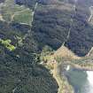
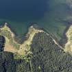
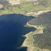
This burial-ground is situated about l00m from the shore of a bay on the E side of Loch Gair. It comprises an oval enclosure measuring 44m from E to W by 25m, within a lime-mortared wall of 19th-century type, having iron gates to the N. The site originally formed a platform of smaller dimensions, and there is a short slope down to the wall all round, but there is no evidence of an earlier boundary. A small stream runs a short distance N of the site, but there is no evidence of a reported well, and the local drainage has been much altered by forestry operations (en.1).
At the centre of the burial-ground there is an enclosure measuring 4.1m by 4.3m within a wall, mainly of drystone rubble, 0.6m thick and l.3m high; the doorway is at the E end of the S wall. There are no visible monuments, and it is not known which family had the enclosure erected. This structure may occupy the site of the 'chapel of Kilbryde at Lochgersyde', which was recorded in 1617 (en.2).
ARCHITECTURAL FRAGMENT. Re-used as a headstone there is a schist slab, 1.42m by 0.44m by 0.l3m in thickness, damaged at one edge. Extending along its length, 70mm from one edge, there is an untapered 'shaft' 0.l8m wide and 60mm in relief, which returns 0.l2m from one end of the slab; at the other end there is a splayed return on the other side. Although this has been interpreted as a cross-slab (en.3) the tooling suggests a late medieval or later date, and the fragment was probably a door-lintel, since it lacks the wear associated with a threshold. This may have come from the old castle at Lochgair (No. 136), or from an earlier building within the enclosure.
FUNERARY MONUMENTS. The burial-ground contains many rough grave markers. Except for the two monuments described below, most of the existing headstones are of late 18th- or 19th-century date.
(1) Sandstone headstone having a shaped top with scrolls at the outer angles. Below the initials WP there is an inscription to Iohn Paterson, 'gardinar', who died in 1722 aged 45. On the back, below the initials IPG, there are emblems of mortality and tools including a saw, shears and crossed ?pruning-hooks. John Paterson, gardener at Lochgair, supplied artichokes for Inveraray Castle in 1721 (en.4).
(2) Recumbent slab bearing the initials IBEMA and the date 1730.
RCAHMS 1992, visited April 1988

