
Lephinchapel, Chapel


Chapel (Period Unassigned), Enclosure (Period Unassigned)(Possible)
Site Name Lephinchapel, Chapel
Classification Chapel (Period Unassigned), Enclosure (Period Unassigned)(Possible)
Canmore ID 40034
Site Number NR99SE 1
NGR NR 96644 90660
Datum OSGB36 - NGR
Permalink http://canmore.org.uk/site/40034


- Council Argyll And Bute
- Parish Strathlachlan
- Former Region Strathclyde
- Former District Argyll And Bute
- Former County Argyll
NR99SE 1 96644 90660.
(NR 9660 9065) Chapel (NR) (In Ruins)
OS 6" map (1900)
The chapel here is probably of late date. The foundations and surrounding garth wall can be seen just above the shore in a field opposite Lephinchapel.
M Paterson 1970
The remains of this chapel measure 5.8m E-W by 3.6m internally within walls up to 1.7m wide and 0.4m high. The entrance is on the N. The surrounding dyke remains only on the W and SW sides.
Resurveyed at 1/2500.
Visited by OS (DWR) 28 November 1972
As described in the previous field report.
Surveyed at 1/10,000.
Visited by OS (TRG) 7 October 1976
Field Visit (July 1986)
The remains of this chapel are situated in arable ground 40mfrom the E shore of Loch Fyne and 250m WNW of Lephinchapel farmhouse. To the N of the chapel there is an uncultivated area measuring about 13m by 15m, but no enclosing wall or gravemarkers could be identified at the date of visit.
The chapel measures about 6.5m from ESE to WNW by 3.8m within turf-grown walls about 1m in thickness. Field-clearance material has been piled on the Sand W walls, but a short length of drystone masonry is visible in the outer face of the W wall. The entrance may be marked by a slight depression in the mound forming the N wall. The name Lephinchapel is first recorded in 1663 (en.1*), and the original dedication is unknown.
RCAHMS 1992, visited July 1986
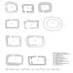
Measured Survey (1986)
RCAHMS surveyed the chapel, Lephinchapel in 1986 producing a plan at a scale of 1:100. The plan was redrawn in ink and published at a scale of 1:1000 (RCAHMS 1992, 190B). The plan was also included in an illustration of comparative plans of early chapels published at a scale of 1:250 (RCAHMS 1992, 6D).

