
Unst, Underhoull


Burnt Mound (Prehistoric), Quern(S) (Period Unassigned), Vessel(S) (Steatite)(Period Unassigned)
Site Name Unst, Underhoull
Classification Burnt Mound (Prehistoric), Quern(S) (Period Unassigned), Vessel(S) (Steatite)(Period Unassigned)
Canmore ID 40
Site Number HP50SE 20
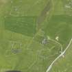
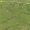
NGR HP 5767 0432
Datum OSGB36 - NGR
Permalink http://canmore.org.uk/site/40


- Council Shetland Islands
- Parish Unst
- Former Region Shetland Islands Area
- Former District Shetland
- Former County Shetland
Field Visit (5 May 1969)
At HP 5767 0434, is an amorphous burnt mound with some large earthfast stones protruding but forming no recognisable structures. Some 30m to the WNW in a modern dry-stone dyke, two fragments of a square steatite vessel were found by Lt-Col Edmondston in 1962, and donated to the Shetland Museum (ARC 65528). Part of a large steatite bowl was seen in the same spot at the time of investigation.
Surveyed at 1:2500
Recorded by OS (NKB) 5 May 1969
Desk Based Assessment (1969)
HP50SE 20 5767 0432
A large, irregular mound some 70 feet in diameter which though largely composed of small burnt stones, has none of the other characteristic features of the burnt mounds, lies a short distance SE of Newhouse. (HP 5761 0436).
The mound has never been scientifically explored, but it has frequently been dug into for building stone, and though no very substantial traces of built structure have been observed, it is reported that stones set on edge as if to mark the circumference of the mound, were exposed as well as a large drain or small passage.
Many relics have been found, including pot-sherds, fragments of broken steatite vessels, stone implements and three non-rotary querns; one of these, like a similar quern found at Jarlshof (HU30NE 1) had evidently been used for levigating clay as a thin coating of clay still adhered to the inside. A stone with a perforation at one end, which can likewise be matched at Jarlshof, is still to be seen projecting to a height of 10.5 inches from the surface of the mound. These points of similarity suggest interesting possibilities.
RCAHMS 1946
Information from OS Index Card.

