
Fearnoch


Cairn (Prehistoric)
Site Name Fearnoch
Classification Cairn (Prehistoric)
Alternative Name(s) Kilfinnan
Canmore ID 39872
Site Number NR97NW 2
NGR NR 92688 79398
Datum OSGB36 - NGR
Permalink http://canmore.org.uk/site/39872


- Council Argyll And Bute
- Parish Kilfinan
- Former Region Strathclyde
- Former District Argyll And Bute
- Former County Argyll
Field Visit (18 September 1942)
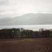
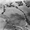
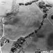
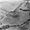
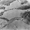
On the cultivable flat terrace of the 25 ft beach, N of Kilfinnan River and about 700 yards from the present beach, is a grassy mound 46 ft in diameter and about 4 ft high. Rabbit-holes show that it is composed of sandy soil and pebbles. It seems to have been a little disturbed on the SE.
Visited by RCAHMS (VGC) 18 September 1942.
Field Visit (7 November 1972)
Resurveyed at 1:2500.
Visited by OS (IA) 7 November 1972.
Field Visit (April 1987)
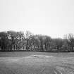
Situated in an arable field on the raised beach 300m S of Fearnoch, there is a grass-covered stony mound about 15m in diameter and 1.2m in height. The N edge of the cairn has been trimmed by the plough.
RCAHMS 1988, visited April 1987.

