|
Photographs and Off-line Digital Images |
A 62841 CN |
|
RCAHMS |
1987 |
Item Level |
|
|
Photographs and Off-line Digital Images |
A 62841 CT |
|
RCAHMS |
1987 |
Item Level |
|
|
Photographs and Off-line Digital Images |
A 62841 |
|
RCAHMS |
1987 |
Item Level |
|
|
Photographs and Off-line Digital Images |
D 57391 |
RCAHMS Aerial Photography |
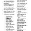
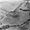
Oblique aerial view centred on the remains of the cairn, cropmarks of the possible field boundaries and further cropmarks, taken from the SE. |
28/7/1999 |
Item Level |
|
|
Photographs and Off-line Digital Images |
D 57392 |
RCAHMS Aerial Photography |
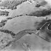
Oblique aerial view centred on the remains of the cairn, cropmarks of the possible field boundaries and further cropmarks, taken from the ENE. |
28/7/1999 |
Item Level |
|
|
Photographs and Off-line Digital Images |
D 57393 |
RCAHMS Aerial Photography |
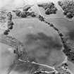
Oblique aerial view centred on the remains of the cairn, cropmarks of the possible field boundaries and further cropmarks, taken from the ENE. |
28/7/1999 |
Item Level |
|
|
Photographs and Off-line Digital Images |
D 57394 |
RCAHMS Aerial Photography |
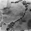
Oblique aerial view centred on the remains of the cairn, cropmarks of the possible field boundaries and further cropmarks, taken from the NNW. |
28/7/1999 |
Item Level |
|
 |
Digital Files (Non-image) |
WP 003403 |
Records of the Royal Commission on the Ancient and Historical Monuments of Scotland (RCAHMS), Edinbu |
RCAHMS Emergency Survey: Typescripts (Argyll). |
c. 1943 |
Item Level |
|
|
Manuscripts |
MS 36/273 |
Records of the Royal Commission on the Ancient and Historical Monuments of Scotland (RCAHMS), Edinbu |
RCAHMS Emergency Survey; manuscripts |
7/1942 |
Item Level |
|
 |
On-line Digital Images |
SC 1723827 |
RCAHMS Aerial Photography |
Oblique aerial view centred on the remains of the cairn, cropmarks of the possible field boundaries and further cropmarks, taken from the SE. |
28/7/1999 |
Item Level |
|
 |
On-line Digital Images |
SC 1723828 |
RCAHMS Aerial Photography |
Oblique aerial view centred on the remains of the cairn, cropmarks of the possible field boundaries and further cropmarks, taken from the ENE. |
28/7/1999 |
Item Level |
|
 |
On-line Digital Images |
SC 1723829 |
RCAHMS Aerial Photography |
Oblique aerial view centred on the remains of the cairn, cropmarks of the possible field boundaries and further cropmarks, taken from the ENE. |
28/7/1999 |
Item Level |
|
 |
On-line Digital Images |
SC 1723830 |
RCAHMS Aerial Photography |
Oblique aerial view centred on the remains of the cairn, cropmarks of the possible field boundaries and further cropmarks, taken from the NNW. |
28/7/1999 |
Item Level |
|
 |
On-line Digital Images |
SC 2261572 |
|
RCAHMS |
1987 |
Item Level |
|
 |
On-line Digital Images |
SC 2261573 |
|
RCAHMS |
1987 |
Item Level |
|
 |
On-line Digital Images |
SC 2419266 |
Records of the Ordnance Survey, Southampton, Hampshire, England |
Fearnoch, NR97NW 2, Ordnance Survey index card, Recto |
c. 1958 |
Item Level |
|
 |
On-line Digital Images |
SC 2419267 |
Records of the Ordnance Survey, Southampton, Hampshire, England |
Fearnoch, NR97NW 2, Ordnance Survey index card, Recto |
c. 1958 |
Item Level |
|
 |
On-line Digital Images |
SC 2419268 |
Records of the Ordnance Survey, Southampton, Hampshire, England |
Fearnoch, NR97NW 2, Ordnance Survey index card, Recto |
c. 1958 |
Item Level |
|
|
All Other |
551 166/1/1 |
Records of the Ordnance Survey, Southampton, Hampshire, England |
Archaeological site card index ('495' cards) |
1947 |
Sub-Group Level |
|


