
Arran, Tormore


Chambered Cairn (Neolithic), Cinerary Urn(S) (Period Unassigned), Flake(S) (Pitchstone)(Period Unassigned), Hammer (Stone)(Period Unassigned), Unidentified Flint(S) (Flint)(Period Unassigned)
Site Name Arran, Tormore
Classification Chambered Cairn (Neolithic), Cinerary Urn(S) (Period Unassigned), Flake(S) (Pitchstone)(Period Unassigned), Hammer (Stone)(Period Unassigned), Unidentified Flint(S) (Flint)(Period Unassigned)
Alternative Name(s) Tormore 1; Long Cairn; Crochandoon
Canmore ID 39779
Site Number NR93SW 9
NGR NR 90314 31056
Datum OSGB36 - NGR
Permalink http://canmore.org.uk/site/39779


- Council North Ayrshire
- Parish Kilmory
- Former Region Strathclyde
- Former District Cunninghame
- Former County Buteshire
NR93SW 9 9031 3106.
(NR 9031 3105) Cairn (NR)
Stone Hammer and Flint Implements found AD 1909 (NAT)
OS 6" map, Buteshire, (1924)
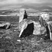
Tormore I: Clyde group, long cairn: The material of this cairn had been almost totally removed by 1900 (J Bryce 1902) though some must have survived till about 1861 (J McArthur 1861). The whole area is now covered by peat. The surviving orthostats suggest that the cairn has been 107ft long by probably 65ft across the wider NNE end, where there has been a deep crescentic facade of orthostats some 50ft across by 24ft deep. An old cart track passes along the W side of the site and its E edge may roughly indicate the W edge of the cairn. The chamber is entered at the N end from the centre of the facade. It consists of 3 compartments. In 1900, when Bryce cleared the compartments, it was in the same condition as today, but containing 3ft of debris so that its interior was level with the surrounding moor. The artifacts he found are now in the NMAS (Acc Nos: EO 240-254; 327) and include a macehead, Grooved Ware sherds, probable Cinerary Urn sherds, 'U' sherds, flint implements and pitchstone flakes.
Sixty-three feet S of the chamber are two large slabs, presumably part of a subsidiary chamber or cist.
Information from OS (IF) 14 February 1973
Sources: A S Henshall 1972; T Bryce 1902; J McArthur 1861.
Field Visit (29 September 1977)
NR 9031 3106. The remains of this chambered cairn, as described, occupy a focal position on rising E-facing moorland at 100ft OD. The three-compartment chamber is clear of debris and in stable condition. Only two stones of the hornwork facade remain standing, but the fallen position of others clearly shows its curved line. The extent of the cairn can only be estimated because no stone scatter is visible on the flat peat-covered surrounding area; however isolated loose stone was detected by probing and three small orthostats are set near the edge of a 30.0m N-S by 17.0m E-W patch which is conspicuously devoid of bracken growth. The two megalithic set slabs to the S have packing stones forming the N end of a probable subsidiary chamber 1.2m deep. Surrounded by amorphous dumping,(? excavation debris) the relationship of this chamber to the suggested cairn extent is uncertain.
Surveyed at 1:10 000.
Visited by OS (J R L) 29 September 1977.
Note (23 July 2018 - 24 July 2018)
The location, classification and period of this site have been reviewed.
HES Survey and Recording 23-24 July 2018.

