
Flannan Isles, Eilean Mor, Tom Na Geodha


Shieling Hut(S) (Post Medieval)
Site Name Flannan Isles, Eilean Mor, Tom Na Geodha
Classification Shieling Hut(S) (Post Medieval)
Alternative Name(s) The Bothies Of The Clan Macphail
Canmore ID 3973
Site Number NA74NW 3
NGR NA 72332 46900
Datum OSGB36 - NGR
Permalink http://canmore.org.uk/site/3973


- Council Western Isles
- Parish Uig
- Former Region Western Isles Islands Area
- Former District Western Isles
- Former County Ross And Cromarty
FLANNAN ISLES (off Lewis) also known as THE SEVEN HUNTERS Named after the 7th century Irish saint, this group of sea-pounded crags was regarded as a refuge of great sanctity, as well as being a rich source of seabirds for Lewismen, who also pastured their sheep here.
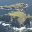
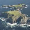
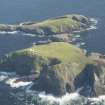
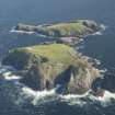
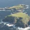
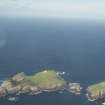
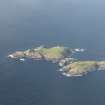
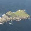
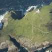
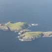
EILEAN MOR, the main isle, comprises 39 acres and has no sheltered landing place. David A Stevenson's Lighthouse, 1896-9 (automated 1971) towers atop 300 ft cliffs. It is a place haunted by the unsolved mystery of the three lighthouse keepers, who disappeared in December 1900. An uneaten meal lay on the table, a chair had been overturned, and two sets of oilskins were missing, but all three men had vanished and no trace of them has ever been found. Below the lighthouse, Teampall Beannachadh (blessing house) - the Chapel of St. Flannan - is a drystone-walled structure with a roughly remade vaulted slab roof, a door in its west end. On Maol nam Both, a headland beyond a now fragmentary retaining wall, the Clan Macphail bothies are said to be the remains of two monks' cells, part of a small early Celtic monastic settlement, although for centuries they have been used as shelters by fowlers
Taken from "Western Seaboard: An Illustrated Architectural Guide", by Mary Miers, 2008. Published by the Rutland Press http://www.rias.org.uk

NA74NW 3 7231 4690
(NA 7231 4680) 'The Bothies of the Clan MacPhail' - Two drystone structures, 30' apart, the larger of which is similar in type to that on the "Pigmies' Isle" (NB56NW 4). The larger building has a total length of 27 1/4' and consists of a passage some 2' wide and high, which passes through an oval chamber 6' by 4 3/4' by 2 3/4' high at the W end, a central rectangular chamber 8' by 8 1/2', covered with a beehive roof 6' high, and containing an aumbry in the N wall, and expands at the E end as a lobby 4 1/2' by 3 1/4' by 2 3/4' high.
In the smaller building a short curved passage 3' broad and 3' high swings round on the N and opens in a chamber, with rounded ends, that measures 10 1/2' by 3 1/2' by 5 1/2' high, and is covered with a beehive roof. On the S side there is a passage 18" by 3'2" by 2'8" high, and where this opens off the main chamber a flagstone 4" thick and 18" square projects within the main chamber.
F L W Thomas 1870; RCAHMS 1928, visited 1928; M Stewart 1933
Two beehive-type shielings generally as described. A hearth c 0.5m square exists in the central chamber of the larger shieling 'A' and there are the probable remains of a third chamber to the right of the entrance. A wall of upright slabs commencing in front of the shielings runs SE to the edge of a geo to cut the promontory on which the site stands. Just outside this wall is a well. (See NA74NW 2).
The name 'Bothies of the Clan MacPhail' could not be confirmed.
Visited by OS (R D) 16 July 1971
Two unroofed shieling-huts, which are annotated as Ruins and attached to a length of wall, are depicted on the 1st edition of the OS 6-inch map (Ross-shire, Island of Lewis 1854, sheet 47).
Two black dots annotated as Old Shielings and part of the wall are shown on the current edition of the OS 1:10000 map (1972).
Information from RCAHMS (SAH), 25 June 1997.
Field Visit (21 October 1924)
Bothies of the Clan Macphail.
At the north-western end of Eilean Mor are the remains of two drystone structures, some 30 feet apart, of the type noted at the ‘Pygmies’ Isle’ in Lewis [NB56NW 4]. They are built of a poor quality of granite found nearby, which has been used undressed. The larger building has a total length of 27 ¼ feet and consists of a passage some 2 feet in width and height, which passes through an oval chamber 6 feet by 4 ¾ feet by 2 ¾ feet high at the western end, a central rectangular chamber, 8 by 8 ½ feet, covered with a beehive roof 6 feet in height and containing an aumbry in the north wall, and expands at the eastern end as a lobby 4 ½ by 3 ¼ by 2 ¾ feet high (Fig. 76).
In the smaller building a short curved passage 3 feet broad and 3 feet high swings round on the north and opens in a chamber with rounded ends that measures 10 ½ by 3 ½ by 5 ½ feet high, and is covered with a ‘beehive’ roof. On the southern side there is a passage 18 inches by 3 feet 2 inches by 2 feet 8 inches high, and where this opens of the main chamber a flagstone 4 inches thick and 18 inches square projects within the main chamber.
RCAHMS 1928, visited 21 October 1924.
[NB 'the report on structures in the Flannain Isles is based on information and photographs supplied by Mr Cadger, District Superintendent of Lighthouses, through the friendly co-operation of Mr J Dick Peddie, Secretary to the Northern Lighthouse Board (RCAHMS 1928, vi)]
Field Visit (4 June 2014)
Two drystone buildings are situated on ground infested with puffin burrows near the top of the southern flank of Tom na Geodha (Hill of the Geo), the westernmost summit of Eilean Mòr. The larger, which probably functioned as a bothy, lies close to the edge of a deep geo running in to the cliffs on the N side of the island, while the smaller building, which may have been a store, lies about 15m to the WSW. Both buildings have been finished with a covering of turf, now eroded away.
The larger building is roughly oval in external plan, measuring about 9m from ENE to WSW by 5m transversely over walls that are up to 1.3m in thickness. A sub-rectangular central chamber measures 2.7m from N to S by up to 2.4m transversely, covered by a corbelled roof that survives to 1.5m in height. A small opening in the N wall is probably the remains of a storage recess 0.35m in width. The chamber is entered from the east by a passageway 0.6m in width and 2.3m in length culminating in a external entrance 1m in width. The eastern section of this passage, previously described as a lobby (Muir 1861; RCAHMS 1928), is formed by a secondary skin of stone up to 1.3m in thickness, with a small recess 0.6m in width in its northern wall. A second passageway to the west leads to a second poorly preserved sub-rectangular chamber that measures 1.8m by 1.4m, and beyond to a second entranceway, now collapsed (see Muir 1885, 60, plan). Another opening on the south side of this chamber is probably a storage recess. A hearth recorded in the central chamber in 1971 (OS) was not recorded. The structure sits over the northern half of a mass of fallen stone roughly 12m in diameter. Amongst the rubble there are three upright slabs on the E side set sufficiently far out to suggest that they may represent part of an earlier structure.
Some 8m to the west, the smaller building is roughly circular on plan, measuring about 5m in diameter overall. The interior is sub-rectangular and measures about 2.6m from NW to SE by 1.2m within a surviving skin of drystone between 0.3 and 0.4m in thickness, and up to 1.5m in height. Set into the side-walls at each corner is a semi-circular corbelled recess, the best preserved of which measures 0.95m in width, 0.9m in depth and 1m in height. The entrance passage, measuring 0.6m in width and 1.2m in length, is centrally placed in the SE wall. One of its lintels survives in its original position, but a single vertical pillar has been added at a later date to support the roof, possibly in July 1959 when the building was used as a bird hide (Baird 1960). This building is surrounded by a mass of fallen stone some 10m in diameter, and a single upright stone at the southern edge may represent part of an earlier structure.
During the late 17th century the Flannan Isles played host to seventy sheep and witnessed an annual visit by the inhabitants of Lewis to make a ‘great purchase of fowls, eggs, down, feathers and quills’ (Martin 1703, 16). However, it is not until 1859 that a detailed record of the ‘Bothien Clann Igphail (Bothies of Macphail’s sons or kinsmen)’ was made. Published with a plan, a description of the eastern structure by the ecclesiologist T S Muir makes it clear that both of its chambers were roofed at that time, each with a ‘kind of dome, with a small circular hole in the crown, 6 feet 10 inches from the floor’ (Muir 1861, 181–2; 1885, 60, plan; cf Thomas 1870). A note and photographs provided by the Northern Lighthouse Board in 1924 formed the basis of a description of both buildings by RCAHMS (1928, No. 106, fig.; see also Stewart 1933, fig. 28).
Visited by RCAHMS (GFG), J Harden, S Halliday, J Raven 4 June 2014

