
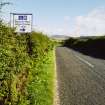
Arran, Machrie Moor 10


Cairn (Bronze Age)
Site Name Arran, Machrie Moor 10
Classification Cairn (Bronze Age)
Alternative Name(s) Moss Farm Road Stone Circle; Machrie Moor
Canmore ID 39726
Site Number NR93SW 3
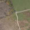
NGR NR 90058 32655
Datum OSGB36 - NGR
Permalink http://canmore.org.uk/site/39726


- Council North Ayrshire
- Parish Kilmory
- Former Region Strathclyde
- Former District Cunninghame
- Former County Buteshire
NR93SW 3 90056 32650
See also NR93SW 1, NR93SW 10, NR93SW 11.
(NR 9006 3265) Cairn and Circle (NR)
OS 6" map, Buteshire, (1924)
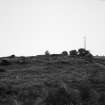
Remains of a Bronze Age cairn and stone circle (S Piggott and W D Simpson 1970). The circle is 63ft in diameter, and was composed of a complete row of stones, 3-4ft high in 1861. It was not excavated by Bryce as the appearance of the interior led him to believe that it had already been robbed. The ONB refers to a large cairn, partly demolished. Nine large upright stones were irregularly placed around it, many others having been removed.
Information from OS (IF) 3 April 1973.
Sources: J Bryce 1863; Name Book 1864
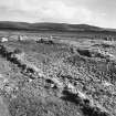
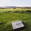
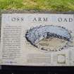
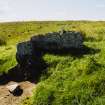
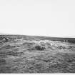
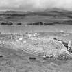
The Moss Farm Road Stone Circle seems to have been a huge cairn of small stones encircled by a kerb of large granite blocks placed close together.
R McLellan 1977
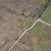
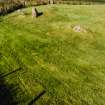
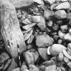
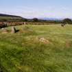
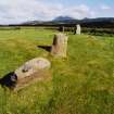
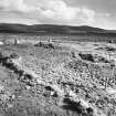
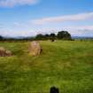
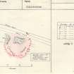
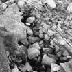
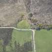
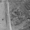
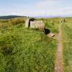
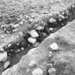
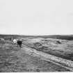
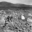
NR 9005 3265. This badly mutilated mound is a robbed cairn with the remains of a conspicuous kerb. It measures 23.0m in diameter and has an average height of 0.8m. A modern fence and a farm track have cut through the north arc and a succession of stone robbing and dumping has disfigured the interior. The kerb consists of seven upright stones, ranging in height from 0.8m to 1.3m and at least five more large stones now on edge.
Surveyed at 1:10,000.
Visited by OS (BS) 15 September 1977
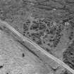
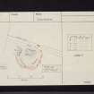
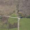
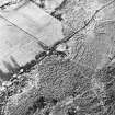
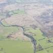
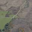
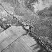
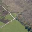
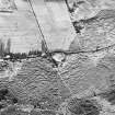
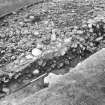
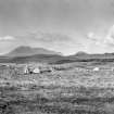
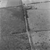
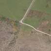
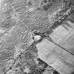
Aerial Photography (1970)
Oblique aerial photographs of the remains of cairn and stone circle, Moss Farm Road, Arran, taken by John Dewar in 1970.
Excavation (1978 - 1979)
A complex ring-cairn. Partial excavation of the SW quadrant in 1978-9 revealed that the cairn had been enclosed in a circle of sandstone slabs 21.8m in diameter. Only 5 of these remain. A 3m wide x 0.7m stoney bank surrounded this circle and within it was a low penannular cairn of heavy boulders capped with small angular pieces of red sandstone over which modern dumping of stones had occurred when the track was cut through the N part of the cairn.
A Burl 1977; 1980.
Publication Account (1985)
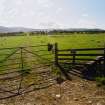
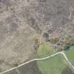
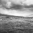
The area immediately around the abandoned steading at Moss Farm contains Scotland's most remarkable concentration of neolithic and bronze-age monuments. Included within this group are chambered cairns, round cairns, stone circles, standing stones, and hut-circles and field-systems. Only the plincipal monuments which are in state care are discussed in detail below, and for the convenience of the visitor the monuments are described from west to east in the order in which they will be encountered if approached from the track to Moss Farm.
1 Cairn (Moss Fann Road)
The track to Moss Farm clips the north side of the sadly mutilated remains of this large round cairn (probably of bronze-age date). It measures about 19m in diameter and is surrounded by an impressive boulder kerb which, in the past, has led to its erroneous descliption as a stone circle. The form and size of the cairn are comparable with those of Auchagallon (no. 95) and the two monuments are probably closely related. A slit trench which crosses the site is the poorly back-filled remains of a recent excavation.
2 Chambered Cairn
About 110m south-east of the first gate east of the Moss Farm Road cairn, there are the wasted remains of a chambered cairn which is straddled by the track. Its position is indicated by a lone tree and all that survives are parts of the chamber, lying between the track and the fence, and traces of the mound on the north side of the track.
3 Stone Circle
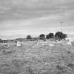
This unusual stone circle consists of two concentric Iings of stones; the outer is slightly egg-shaped and measures about 18m in maximum diameter, while the inner ring is circular measuting 11.5m in diameter. The stones of both rings are small rounded boulders and contrast with the impressive slabs seen elsewhere in the complex. Although this site is normally described as a double stone circle, it is not clear if the outerling was designed as a free-standing setting or was intended to be a kerb to the platform on which the inner circle rests. In the 19th century a cist was discovered in the inner circle.
4 Stone Circle
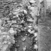
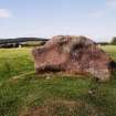
This small circle now complises four low granite boulders and it is not known whether there may oliginally have been more. Excavation in 1861 revealed a central cist containing a Food Vessel, a bronze pin or awl, and a group of flints. The finds are in the National Museum of Antiquities of Scotland, Edinburgh.
5 Stone Circle
Only four of the oliginal total of nine stones of this circle can now be seen and of these three have been reduced to stumps which barely project above the level of the peat. Excavation in 1861 revealed a central cist with a second lying a little to the south. In the latter there was a crouched inhumation accompanied by two flint flakes.
6 Stone Circle
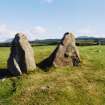
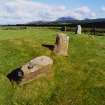
This is the most spectacular of the Moss Farm stone circles with the three surviving uptights standing to a maximum height of up to 5.5m, making them amongst the tallest standing stones, in Scotland. The circle originally consisted of seven or eight stones, and the remains of some of the fallen monoliths litter the surrounding ground. In the more recent past an attempt has been made to reuse one of the fallen stones by converting it to the two halves of a set of mill stones, but the project was abandoned when the upper half broke in two. In 1861 two cists were found in the circle; one contained a Food Vessel with a cremation, and in the second there was a crouched inhumation.
7 Stone Circle
Although several of the stones of this circle (strictly speaking an ellipse) appear to be missing or displaced, it probably originally consisted of a ring of twelve stones arranged in an unusual manner with tall sandstone slabs alternating with squat granite boulders. This is the only circle in the Moss Fann group to have this feature which, in fact, is rarely seen in Scotland as a whole.
8 Stone Circle
The preceding stone circles at Moss Farm have all been known since the mid-19th century, but this final circle was only identified recently when attention was drawn to a number of stones projecting through the peat. On excavation they proved to be part of a circle of ten stones, which have subsequently been left exposed. Between the stones there were the post-holes of an earlier ring of timber uprights, indicating a rather more complex history than the surface traces might have suggested.
Information from ‘Exploring Scotland’s Heritage: The Clyde Estuary and Central Region’, (1985).
Airborne Laser Scanning Interpretation (12 July 2018)
The location, classification and period of this site have been reviewed.
HES Survey and Recording 12 July 2018

