
Arran, Moss Farm


Cist (Neolithic) - (Bronze Age)
Site Name Arran, Moss Farm
Classification Cist (Neolithic) - (Bronze Age)
Alternative Name(s) Machrie Moor
Canmore ID 39706
Site Number NR93SW 11
NGR NR 9073 3237
Datum OSGB36 - NGR
Permalink http://canmore.org.uk/site/39706


- Council North Ayrshire
- Parish Kilmory
- Former Region Strathclyde
- Former District Cunninghame
- Former County Buteshire
NR93SW 11 9073 3237
See also NR93SW 1, NR93SW 3, NR93SW 10.
(NR 9075 3237) Cist (NR)
OS 6" map, Buteshire, (1924)
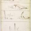
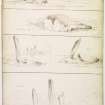
A small square, composed of four massive blocks of sandstone, not vertically, but horizontally laid. It was recently dug into, and an urn and some flint arrowheads found in it. (No doubt this refers to Bryce's excavation).
Name Book 1864.
An 'enclosure' like an open raised grave, formed of five sandstone slabs placed with their edges in the ground, standing 2-3ft above the surface, so even all round that a large slab may once have fitted on as a lid. It measures 6ft E-W by 4ft N-S, two stones form the E side, and one stone on each of the other sides. The interior of the 'enclosure' was excavated in May 1861 to a depth of 3ft without finding a cist or any remains except for 'a fragment of a flint arrowhead, like a small piece that might have chipped off a larger one'.
J Bryce 1863.
Noted as a Bronze Age short cist by MacKie.
E W MacKie 1975.
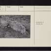
NR 9073 3237. The remains of a possible chambered cairn situated on a crest of high moorland at about 100ft OD.
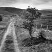
Two touching upright slabs at right angles remain and they have the proportions of a chamber rather than a cist. One, orientated E-W, measures 2.0m long, 1.1m high and 0.4m wide, and the other, orientated N-S, measures 1.0 long 0.8m high and 0.4m at its widest point. The stones are isolated between a fence line and a farm track; an amorphous spread of probable cairn material, overgrown and without definable shape or limit lies to the N of the track.
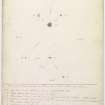
Surveyed at 1:10 000.
Visited by OS (J R L) 18 September 1977.
Note (23 July 2018 - 24 July 2018)
The location, classification and period of this site have been reviewed.
HES Survey and Recording 23-24 July 2018.

