
St Kilda, Boreray, 'tigh Stallar'


Cleit (Post Medieval), Settlement (Period Unknown)
Site Name St Kilda, Boreray, 'tigh Stallar'
Classification Cleit (Post Medieval), Settlement (Period Unknown)
Alternative Name(s) Taigh Stallair
Canmore ID 3968
Site Number NA10SE 1
NGR NA 15248 05078
Datum OSGB36 - NGR
Permalink http://canmore.org.uk/site/3968


- Council Western Isles
- Parish Harris
- Former Region Western Isles Islands Area
- Former District Western Isles
- Former County Inverness-shire
Note (1928)
Mr Sands refers to an ancient building “on the face of the hill called Sgal overlooking the bay…It had been covered with stones, but was found again last summer (1875). I went and threw out the rubbish. It is built with comparatively small stones…It contains two croopan” (i.e. wall beds). He also notes what Martin, in his Late Voyage to St Kilda (1698), called Tigh na Bana-ghaisgeach, ‘House of the Female Warrior’. “It is circular in form, about 9 feet in diameter, and built of flat stones, which converge as they ascend, until the space becomes so narrow that a single stone covers it. This house is covered outside with earth and turf…There were three croopan or beds in the wall”. One of these had already been destroyed, and subsequently a large quantity of stones were taken away. This place was a beehive shieling of the type described on [RCAHMS 1928] p. xli, as its local name, Airidh mhor ("big shieling"), indicated. A piece of wall on the island, called The Dun, is described by Mr Sands on pp. 189-90. Cf. also Proc. Soc. Ant. Scot., X., pp. 702-11. Dr Ross, architect, Inverness, from personal inspection, spoke of it in 1884 in these terms: “A rude wall across the promontory, near the extreme end, is pointed out as the remains of a fortification” (Trans. Inverness Scient. Socy. and Field Club, Vol. III., p. 80). There is an illustration of a bit of the wall in St Kilda, by Norman Heathcote (1900), p. 20. Mr Sands could discover no stone circle on the island of Boreray, as claimed by the Rev. K. Macaulay in his account (1764), “and the St Kildans seem never to have heard of it” (Ibid., XII., p. 189). On Tigh an Stallair on Boreray, of which nothing now remains, see Proc. Soc. Ant. Scot., VII., pp.173-4, and XII., p. 189.
Desk Based Assessment (21 April 1966)
Stallar House described by Macaulay (K Macaulay 1764) and Kennedy (A Kennedy and F W L Thomas 1875), and the discrepancies between them suggest there was more than one such construction. Mathieson, (J Mathieson 1928) however, described it as being similar to the Amazon's House (NA00SE 2) but much larger; the name 'Stallar' having nothing to do with one Stallar, a hermit traditionally associated with Boreray, but is Norse ('Haillr - a shed).
The site was visited in 1960 by Williamson who found it occupied by a small cleit, the stones of Tigh Stallar having evidently been removed to build the adjacent (but now ruined) bothies. He found the circular foundations of beehive bed-chambers and beautifully corbelled vault, entirely underground, which appeared to be intact. Near the cleit, a sherd of crude pottery was picked up (possibly a beaker or pot-rim) with straight line decoration of a type not seen on St Kilda. The southern slopes of Boreray show many other signs of habitation, such as boundary markers in the form of lines of stones and 'attenuated furrows of turf'. There are at least two wells.
J Sands (1875), states that there were then 3 'bee-hive' type houses, occupied by the women who snared birds. The evidence suggests an early settlement site of some permanency, when climatic conditions were more suitable than those of today.
Information from OS (BRS) 21 April 1966
K Macaulay 1764; A Kennedy and F W L Thomas 1875; J Mathieson 1928; K Williamson and J M Boyd 1963; J Sands 1875.
Field Visit (12 August 1967)
Access to Boreray was not possible at time of visit; but the above description indicates a settlement pattern similar to that in Gleann Mor, Hirta, with early 'bee-hive' structures, and later rectangular shieling-type bothies; although the account by Sands and others, tends to infer that all the structures on that remote and inhospitable island were solely constructed for use during the summer season for tending sheep and snaring birds.
Visited by OS (J L D) 12 August 1967.
Field Visit (12 July 2010)
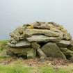
A well-built cleit stands with its roof intact on an artificial mound that evidently contains a substantial stone structure.
The mound is oval on plan, measuring up to 20m in maximum diameter from NW to SE by 14m transversely, and forms a terrace at least 1.7m high in a slight fold in the slope. Its surface has been adapted to provide two garden plots within the field-system that extends across these slopes, one cutting back into its flank on the NW, the other square on its summit immediately up from the cleit and appearing as no more than a low flat-topped mound. The shape of the structure within the main mound cannot be determined without excavation, but two stones immediately below the SW end of the cleit have the appearance of a substantial kerb, below which there is a talus of slabs and large stones, and another exposure of stonework extends this rough line along the lip of the terrace to the SE of the cleit.
In addition, there are at least two chambers within the mound, one exposed beneath the SE wall of the cleit and comprising an arc of corbelled masonry, the other buried beneath the turf and previously only known from a sketch plan by Williamson and Boyd (1963) showing it on the NW side of the cleit. An area of turf 0.8m square was lifted around a single boulder that protruded through the grass in this position, and when this was raised it revealed a void in the roof of a corbelled chamber. Surveyed through this small aperture, the chamber measures at least 2.2m from ENE to WSW by 1.4m transversely and the apex of the roof stands 1.2m above a thick deposit of earth and stones covering the floor. The lintel and jambs of an entrance 0.8m wide choked with this same material could be seen leading off S, while in the wall opposite there is an aumbrey about 0.2m wide and 0.7m deep, which utilises one of the corbel slabs to form a sill. The projection of the plotted line of the entrance passage lies slightly S of the chamber exposed on the other side of the cleit some 3m to the SSE, suggesting that they probably both open off another chamber or passage directly below the cleit, a disposition that also suggests that there is probably at least one more chamber in the mound to the ENE of the cleit.
From what can be seen of the character of this structure it is probably akin to the Amazon’s House on Hirta. It had evidently been partly demolished before the construction of the cleit, which itself is one of the best preserved examples on the island (Mary Harman Boreray 2). It measures 3.45m in length by 2.1m in breadth overall and the top of its roof stands 1.4m in height above the foot of the wall at the lower end on the SW. Three pieces of wood are wedged across the interior, which is 2.5m in length by 0.9m in breadth at the entrance, and two more lie on the floor. The entrance, which is in the NE end, measures 0.6m in height and is blocked with a large upright slab and some smaller stones. Including the lintel over the entrance, the roof is supported upon a total of six slabs spanning the interior, the gaps between them covered with a patchwork of smaller slabs and other stones.
Visited by RCAHMS (SH & IP) 12th July 2010

