
Arran, Creagdhu


Fort (Prehistoric)(Possible), Motte (Medieval)(Possible)
Site Name Arran, Creagdhu
Classification Fort (Prehistoric)(Possible), Motte (Medieval)(Possible)
Alternative Name(s) Craig Dhu
Canmore ID 39658
Site Number NR92SE 3
NGR NR 99753 20813
Datum OSGB36 - NGR
Permalink http://canmore.org.uk/site/39658


- Council North Ayrshire
- Parish Kilmory
- Former Region Strathclyde
- Former District Cunninghame
- Former County Buteshire
NR92SE 3 9975 2082.
(NR 9975 2082) Fort (NR).
OS 6" map, Buteshire, 1st ed., (1864)
A defensive work of the usual character, the natural strong position being supplemented by art on the landward side (ONB 1864). No definite structural remains were seen in 1910, though local tradition was all in favour of this having been the site of a fort. The hill (Creag Dhubh) in several places showed traces of primitive agriculture (Balfour 1910).
Source: Name Book 1864; J A Balfour 1910.
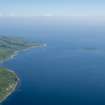
Much of the fort on Bennan Head has been eroded away to the seaward side of the summit on which it stands, but it seems to have had a circular wall of earth or small stones, surrounded by a ditch, though without excavation, nothing can be said of its wall structure. No trace of internal structures existed in 1837 (Paterson 1837).
R McLellan 1970; J Paterson 1837.
A cliff-edge fort mainly utilizing a natural knoll, with only minimal erosion of the precipitous coastal cliff on its E side. It comprises a flat topped knoll the base slopes of which have been cut back and terraced on the W side to give a double scarp effect. On the N and NW sides where the knoll is low and easily approached there is a bivallate defence of low earth and stone banks. These "ramparts" and the terrace on the W inturn to a central entrance.
The knoll top, without trace of walling, has maximum dimensions of 35.0m N-S by 20m E-W, the habitable area being approximately 525 sq metres. This fort is similar in its size and situation to that on Dun Fionn (NS03SW 4).
Surveyed at 1:10 000
Visited by OS (J R L) 28 November 1977.
Note (30 October 2014 - 11 August 2016)
Although this has been previously classified as a fort, and indeed Scheduled as such, the morphology of the earthworks suggest that it is more likely to be the remains of an earth and timber castle. The motte at its core has been tailored partly from a natural knoll backing on to the spectacular cliffs that form the coastal escarpment running down to Bennan Head, and has been scarped around its N and W flanks. This has been enhanced by the addition of twin banks with a medial ditch, which are best preserved on the most easily accessible N side and turn inwards to flank an entrance in the middle of the W side. The level summit of the motte measures some 35m from NE to SW by 20m transversely.
Information from An Atlas of Hillforts of Great Britain and Ireland – 11 August 2016. Atlas of Hillforts SC2468
Note (29 November 2018)
The location, classification and period of this site have been reviewed.
HES Survey and Recording 29 November 2018

